Over the past decade and more, BRGM has become expert in the acquisition and processing of geophysical data (electromagnetic, magnetic and gamma-spectrometry data) using airborne instruments.
Acquiring data in hard-to-reach areas
Airborne geophysics allows the simultaneous implementation of several techniques for acquiring geophysical data quickly, including in areas that are difficult to access (forests, mountains) or which are devoted to a widespread economic activity, except in densely urbanised areas.
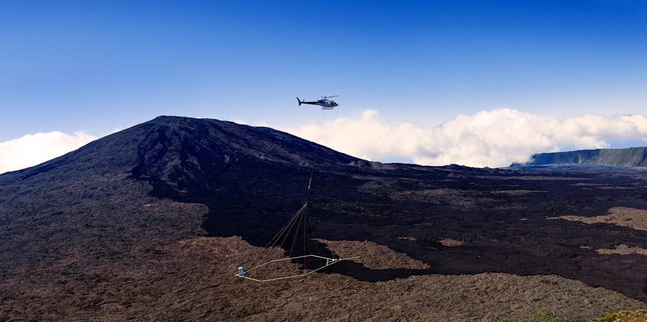
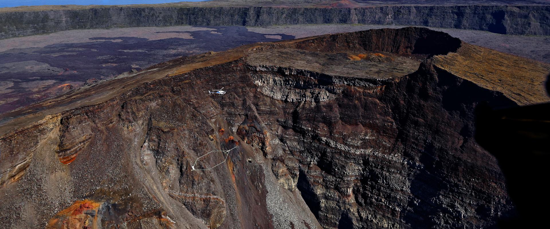
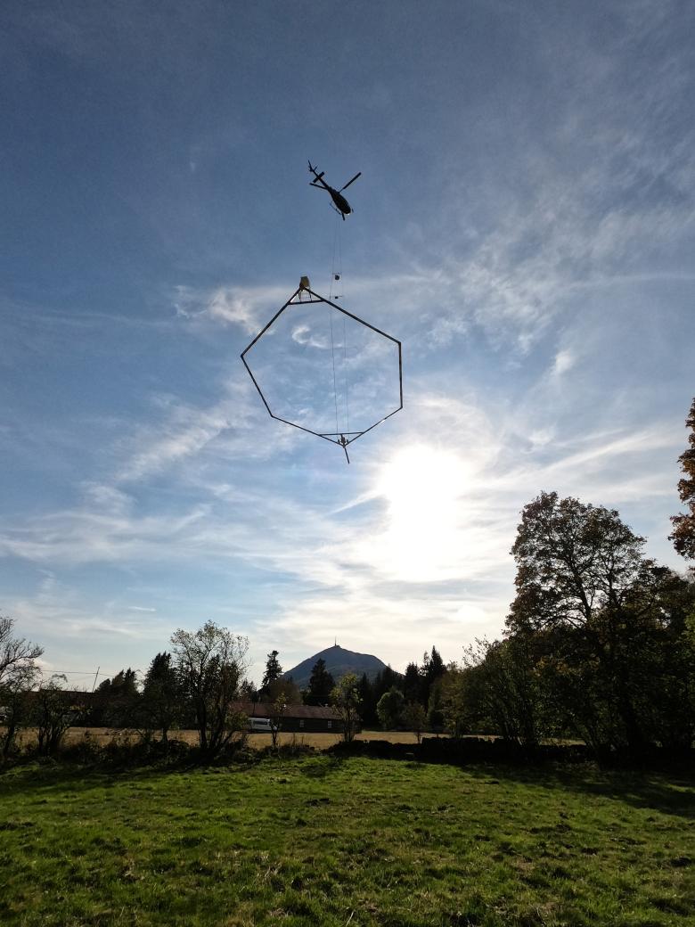
Measurements are made with geophysical instruments, usually carried on an aircraft or suspended under a helicopter. After processing and modelling/inversion, they yield a homogeneous, continuous and geolocated (with GPS precision) image of the geological subsurface environment, in 2D and 3D.
A tool for the French Geological Reference Repository
Airborne geophysics is an essential tool in the French Geological Reference Repository (RGF), a programme led by BRGM to provide France with three-dimensional knowledge of the French subsurface.
It provides useful information for the rational management of resources and the planning of underground space.
Multiple fields of application
Airborne geophysics is a valuable decision-making tool for raw material prospecting, risk management and spatial planning, the assessment and management of groundwater resources or for underground energy extraction.
Coverage of the national territory, region by region
Since the end of the 1990s, BRGM has undertaken repeated airborne geophysical data acquisition campaigns, with the aim of providing complete coverage of the territory, region by region.
The most recent high-resolution surveys were carried out in French Guiana (1996), the Armorican Massif (1998), Centre Region (2008-2009), the Western Paris Basin (2009-2010), Mayotte (2010), Burgundy (2011), Guadeloupe and Martinique (2013), Reunion Island (2014) and New Caledonia (2015). The campaigns are usually carried out with co-financing by BRGM and its local partners and/or Europe.

Airborne geophysics: accessing the data
Surveys up to the 1980s
Until the 1980s, numerous surveys were carried out in France, by targeting restricted areas, mainly for mining purposes, but also for oil prospecting. Due to their age, the data from these surveys are generally only available on paper and must be requested from the companies that acquired them.
Data concerning old airborne geophysical surveys (up to the 1980s) are available via the BRGM Infoterre portal, by loading the "Geophysics/Aeromagnetic campaigns" data layer. This database provides access to the following information in particular:
- area covered by the airborne surveys,
- technical characteristics (flight altitude, spacing, instrumentation),
- date, customer and operator.

Heliborne geophysical survey of La Réunion.
© BRGM - René Carayol
Surveys undertaken since the 1990s
Below you will find the main information on the surveys carried out since the late 1990s.
Access to digital data
Digital airborne geophysical data acquired by BRGM is disseminated in two ways:
- in the form of user licences, with a cost for downloading data,
- and free-of-charge in the framework of research agreements.
Jura (2023)
In August 2023, BRGM and 45-8 Energy launched a helicopter-borne geophysical survey of the Jura foothills. The campaign is part of an ambitious R&D programme aimed at imaging the subsurface in three dimensions. The results of the campaign should enable 45-8 Energy to better characterise a potential natural helium resource as part of its activities under the exclusive licence it has been granted, to prospect in the foothills of the Franche-Comté region.
The campaign is part of a joint R&D programme between the French company, 45-8 Energy, which specialises in the exploration and production of eco-responsible industrial gases such as helium and natural hydrogen, and BRGM (the French geological survey). It will be supplemented by other geophysical fieldwork to be carried out by BRGM in the second half of 2023 to provide a seamless view of the subsurface over the entire Jura foothills to the west of Besançon.
Tarn-et-Garonne (2021)
Le projet ECORSE 82 a pour but d’améliorer la connaissance des nappes d’eau souterraine dans le département et de disposer d’éléments techniques pertinents pour une gestion durable de cette ressource. Il est conduit sous la maîtrise d’ouvrage du Conseil départemental du Tarn-et-Garonne, avec des co-financements de l’agence de l’Eau Adour-Garonne, de la Région Occitanie et du BRGM.
C’est dans le cadre de ce projet que le BRGM a lancé une campagne de géophysique aéroportée, en septembre 2021, sur le Quercy Blanc entre les vallées de la Séoune à l’ouest et du Candé-Lère à l’est. Ce survol a pour but de repérer les contrastes de résistivité électrique du sous-sol. La mesure permettra aux géophysiciens de déterminer les limites entre les couches géologiques et si possible de détecter la profondeur des nappes souterraines, ce jusqu’à 400 mètres de profondeur au mieux.
Nouvelle-Aquitaine (2021)
In order to improve the management of the region's groundwater, BRGM and the Departmental Councils of the Dordogne, Lot-et-Garonne, Lot and Charente – supported by the Nouvelle-Aquitaine Regional Council via the ERDF (European Regional Development Fund) and the Adour-Garonne water agency – launched a hydrogeological research programme, Eaux-SCARS. This project started in September 2021 with the airborne acquisition of geophysical data over the north-eastern section of the Aquitaine Basin. It covered an arc-shaped strip that is 40 km wide and almost 200 km long, stretching from the south of Angoulême (Charente) in the north through the central sectors of Périgueux and Sarlat (Dordogne) to Agen (Lot-et-Garonne) in the south.The aim of this heli-borne survey is to identify electrical resistivity contrasts in the rocks. The data obtained will enable geophysicists to determine the contours of the different geological layers and to better outline the groundwater tables, up to a depth of approximately 400 metres.
Auvergne (Aérovergne, 2020)
In order to gain a better understanding of the subsurface and gather data that can be used by various regional stakeholders, BRGM is launching a heliborne geophysical survey of the famous "Chaîne des Puys" mountain range. The project is co-financed by BRGM and the European Union, via ERDF funds managed by the Auvergne region.
New Caledonia (2015)
BRGM, on behalf of CNRT, in a scientific consortium with the University of Aarhus (Denmark) and UNC, conducted a helicopter-borne geophysical survey of targeted areas of New Caledonia's Grande Terre in May 2015. This acquisition, carried out as part of the Ophiostruct project, dedicated to the study of ophiolite structuring, to better understand lateritic nickel deposits, was co-financed by the CNRT. Taking advantage of the survey, the SGNC financed a geological survey flight over the Boulouparis area and the CGE-VKP financed another over the Koné area for hydrogeological purposes.
Heliborne electromagnetism and magnetism survey
- Zone: targeted areas of New Caledonia's Grande Terre
- Distance covered: 850 linear km
- Acquisition: BRGM/Univ. Aarhus/SkyTEM ApS/Helicocean.
- Acquisition period: May 2015
Access the data
Reunion Island (ReunEM, 2014)
BRGM, in partnership with the EU (under the ERDF), the French Government and the regional authority of La Réunion, conducted a helicopter-borne geophysical survey of the entire island, lasting from April to July 2014, in order to map its geological resources.
Heliborne electromagnetism and magnetism survey
- Zone: Reunion Island
- Service Provider: SkyTEM ApS - Denmark
- Acquisition period: April - July 2014
- Distance covered: about 10,400 linear kilometres
Accessing the data
Guadeloupe (GuadEM, 2013)
BRGM, in partnership with the EU (under the ERDF), the regional authority of La Réunion and the Guadeloupe Water Office, conducted a helicopter-borne geophysical survey of the entire island, in the spring of 2013, in order to map its geological resources.
Heliborne electromagnetism and magnetism survey
- Zone: islands of the Guadeloupe archipelago
- Service Provider: SkyTEM ApS
- Acquisition period: March - April 2013
- Distance covered: 5,394 linear km
Accessing the data
Martinique (MartEM, 2013)
BRGM, in partnership with the EU (under the ERDF), the DEAL, the regional authority of Martinique and the Martinique Water Office, conducted a helicopter-borne geophysical survey of the entire island, in the spring of 2013, in order to map its geological resources.
Heliborne electromagnetism and magnetism survey
- Zone: Martinique Island
- Service Provider: SkyTEM ApS
- Acquisition period: February - March 2013
- Distance covered: 3,730 linear km
Accessing the data
GeoMayotte (Mayotte, 2010)
How can 3D geological mapping be done for volcanic islands with rugged terrain? With the helicopter-borne geophysical campaign carried out in 2011 in Mayotte, BRGM now has the first geological map of the island at a scale of 1:25,000 and a model of the subsurface to a depth of 200 metres.
Heliborne electromagnetism and magnetism survey
- Zone: Martinique Island
- Distance covered: 3,000 linear km
- Acquisition: BRGM/Univ. Aarhus/SkyTEM ApS
- Acquisition period: October 2010
Accessing the data
- Flight plan
- Magnetism
- Electromagnetism
Bourgogne (AéroBourgogne, 2011)
In autumn 2011, BRGM carried out an airborne geophysical survey over the southern 2/3 of the Burgundy region to improve knowledge of the region's subsurface. This campaign was co-financed by BRGM and the Carnot funds (action 2009-24).
Airborne magnetism and gamma spectrometry
- Zone: Burgundy region
- Distance covered: 27,670 linear km
- Service Provider: Terraquest Ltd. - Canada
- Acquisition period: August - Oct. 2011
Access the data
Armorican Massif and Centre region (AéroRégion, 2009-2010)
During the winter of 2009-2010, BRGM carried out an airborne geophysical survey over an area extending to the junction between the Armorican Massif and the Centre region, the Seuil de Poitou and the northern part of the Aquitaine basin.
Airborne magnetism and gamma spectrometry
- Area: Western Paris basin and junction with the Aquitaine basin
- Distance covered: 39,575 linear km
- Service Provider: Terraquest Ltd. - Canada
- Acquisition period: October 2009 - March 2010
Accessing the data
Centre Region (GeoCentre, 2008-2009)
In 2008-2009, BRGM conducted an airborne geophysical survey in the Centre region (magnetism and spectral radiometry). Carried out within the framework of the ResoNat programme, as part of the State-Centre Region Project Contract (2007-2013), the main objective of this campaign was to contribute to the development and rational management of natural resources in the region. It was financed by the Centre Region and BRGM, and by the Carnot 2007-13 action for phase 2.
Phase 1 - Airborne magnetism and gamma spectrometry
- Zone: administrative area of the Centre region
- Distance covered: 43,450 linear km
- Service Provider: Terraquest Ltd. - Canada
- Acquisition period: August 2008 - June 2009
Accessing the data
- Survey data sheet
- Flight plan
- Magnetism
- Gamma spectrometry
Phase 2 - Heliborne Electromagnetism and Magnetism
- Zone: 3 rectangular zones, in the Centre region
- Distance covered: 3,000 linear km
- Service Provider: SkyTEM ApS - Denmark
- Acquisition period: February - March 2009
Accessing the data
- Survey data sheet
- Survey location map
- Courtenay Zone
- Vierzon zone
- Sud Cher zone
Languedoc-Roussillon (Aérosalt, 2008)
Within the framework of a research project financed by BRGM, EUFAR (European Fleet for Airborne Research) and the Carnot funds (action 2008-22), an airborne geophysical survey (magnetism, spectral radiometry and electromagnetism) was carried out in Languedoc-Roussillon in 2008. This campaign covered a pilot area of the coastal plain. Its main objective was to contribute to the protection of the region's water resources.
Airborne magnetism, gamma spectrometry and frequency electromagnetism survey
- Zone: Languedoc coastline from Leucate to Argelès
- Distance covered: 4,500 linear km
- Service Provider: JAC - England/Finland
- Acquisition period: 15-25 September 2008
Accessing the data
- Survey data sheet
- Flight plan
- Gamma-ray spectrometry
- Electromagnetism
- Technical reports of the acquisition
Armorican Massif (1998)
Airborne magnetism and gamma spectrometry survey
- Area: Armorican Massif basement
- Acquisition period: 2nd semester 1998
- Service Provider: Sander Geophysics Ireland Ltd.
- Financing: Ministry of the Economy, Finances and Industry
- Distance covered: 115,700 linear km
- Flight line spacing: 1000/500/250 m
- Flight altitude: 120m above ground level
Accessing the data
- Survey data sheet
- Flight line spacing
- Flight plan
- Magnetism
- Gamma-ray spectrometry
French Guiana (1996)
Airborne magnetism and gamma spectrometry survey
- Zone: 2/3 of northern French Guiana
- Acquisition period: 2nd semester 1996
- Service Provider: CGG - France
- Financing: Ministry of Industry, Post and Telecommunications
- Distance covered: 135,000 linear km
- Flight line spacing: 1000/500/250 m
- Flight altitude: 120m above the canopy
Accessing the data
- Survey data sheet
- Flight line spacing
- Flight plan
- Magnetism
- Gamma spectrometry

Airborne geophysics: frequently asked questions
What is the purpose of airborne geophysical surveys?
The airborne geophysical studies undertaken by BRGM and its partners help to modernise France’s geological infrastructure. The acquisition of this type of innovative data enables us to gain a deeper understanding of the subsurface in France and in its overseas territories. This is one of the missions of BRGM, the French Geological Survey.
Depending on the methods used, airborne geophysics provides information from the surface of the ground to several kilometres below the surface.
In addition to the other information available (geological, drilling, seismic and other maps), airborne geophysics makes it possible to better describe and understand the subsurface, with applications in the fields of spatial planning, resources (water, materials), geological risks, geothermal energy and storage, and in general, of geological knowledge.
Have such studies ever been conducted in France?
Numerous airborne geophysical surveys have already been carried out in France, on behalf of various operators, since the end of the 1960s: until the 1980s they were mainly for mining purposes, then more recently for geo-environmental objectives.
A detailed description (metadata) of the surveys recorded by BRGM on French territory is available on the InfoTerre portal, by loading the "Geophysics/Aeromagnetic campaigns" data layer.
What do the measurements consist of?
There are many airborne geophysical techniques and each is adapted to provide information on one or more surface/subsurface parameters, with different resolutions and penetration depths.
The methods most commonly used by BRGM for imaging France’s subsurface are:
- magnetism: this method records variations in the earth's natural magnetic field (without any transmissions from the aircraft). These variations are rendered in the form of maps, and sophisticated processing techniques are used to produce 3D models of the magnetic properties of rocks from ground level to several kilometres below the surface. This method is typically used in conjunction with other information to model the geology and its formations down to great depths.
- spectral radiometry or gamma spectrometry: this method records the natural radioactive radiation that comes from the first metre of rocks and soils down from ground level (without any transmissions from the aircraft). All rocks naturally contain radioactive isotopes at very low concentrations, which are not harmful to health, and the very sensitive spectrometric detectors flown for this type of measurement make it possible to detect the gamma radiation thus released from the ground. Depending on the mineralogy of the rock, the gamma radiation differs: it is measured and analysed by high-tech sensors and software that can determine the concentrations of Uranium (U), Potassium (K) and Thorium (Th) in the ground. The results of this type of acquisition are rendered in the form of U, K and Th maps. Complementary to geological and pedological maps, these data are analysed to refine the mapping of ground and near-surface geology and to better understand the geochemical state of our environment.
- electromagnetism: this method creates images of the variations in electrical conductivity of the subsurface, from ground level to a few hundred metres below it, depending on the equipment used. This is an active method, i.e. electromagnetic waves are transmitted, propagate in the air and then in the ground, and finally a part is re-emitted by the ground and detected in the measuring device. The return signal measured varies according to the conductivity properties of the subsurface, and sophisticated analysis of these signals can produce 3D models of the subsurface conductivity with a resolution of a few metres at ground level. This method is influenced by the porosity of the rocks and their fluid content (but also by the salinity of these fluids), as well as by the presence of clay.
Why is airborne geophysics useful?
The main advantage of airborne surveys is that they can cover very large areas in a short period of time and thus replace long ground surveys. This type of acquisition can also cover the entire territory, with the exception of built-up areas (which cannot be flown over at low altitude) and certain restricted sites (nuclear power stations, strategic sites, etc.).
Permission to fly is systematically requested before any overflight.
Have you applied for the necessary permits?
Airborne geophysical acquisitions to acquire high resolution data require very low flight altitudes of about 80 to 120m.
Flights over any area under these conditions are subject to an application to the French airspace regulator, the DGAC, and also to the prefectures of the departments concerned. Overflights can only take place if an order has been issued by the two above-mentioned authorities. This order concerns an aircraft and its pilot only, for a specific period.
The companies involved in the acquisitions follow these orders to the letter.
Sensitive sites such as nuclear power plants, military zones, etc. are also subject to specific requests.
Why do you have to fly so low?
To ensure good data acquisition, the optimum flight altitude is between 80 m and 120 m. This altitude is actually a trade-off between the requirements of the measurement technique used, which needs to be as close to the ground as possible, and safety and environmental considerations.
Will there be any financial compensation?
For surveys, the airspace is cleared and all necessary government authorisations for the implementation of this type of study are obtained prior to the overflights. In the unlikely event of an incident directly related to the study, rapid and thorough investigations will be carried out. The operating companies are fully insured for this type of work and will deal with any legitimate claims that may be made.


