The need
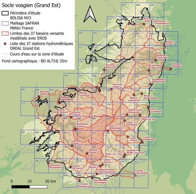
The Vosges Mountain Range (or strictly the Vosges basement, in the geological sense of the term) is made up of a wide variety of metamorphic or magmatic rocks, which contain a groundwater resource that is sensitive to recurrent droughts. A collaborative study conducted by BRGM, DREAL Grand-Est and the University of Lorraine (LOTERR geography research centre) between 2018 and 2020 characterised this water resource throughout the area. BRGM then ran models to determine the long- and medium-term impact of climate change on the water resources available within the Vosges basement on the basis of changes in the recharge rate due to precipitation. Thirty-seven catchment areas were considered in order to anticipate possible future imbalances and difficulties in the most representative way possible.
Results
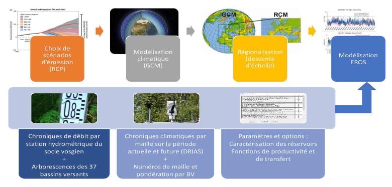
To provide the knowledge required about the vulnerability of water resources in the Vosges Mountains to the impact of climate change, the 37 catchment areas identified within the Vosges basement were modelled using the EROS (Ensemble de Rivières Organisées en Sous Bassins) software developed by BRGM. The study was based on a selection of 14 climate projections determined by combining two Greenhouse Gas Emission scenarios, two statistical regionalisation methods and 4 climate models. The current and future climate records were provided by Météo France, while the watercourse flow records were extracted from the national quantitative surface water data bank (Hydroportail developed by the SCHAPI) for the 37 hydrometric stations selected.
Analysis of the models revealed the following trends:
- A decrease in future recharge of between -1% and -21%, averaged across multiple scenarios at -6% by 2060 and -9% by 2100;
- A decrease in annual flows (averaged across all sub-catchment areas) for most of the scenarios: up to -15% in 2060 and -20% in 2100 for the most pessimistic case;
- Variation in future monthly average flows of -8% by 2060 and -12% by 2100, averaged across multiple scenarios;
- Significant monthly disparities, in particular with a drop in flows during the spring-summer period (up to -40% deficit in July) and an increase in flows during the autumn-winter period (up to +16% surplus in January), averaged across multiple scenarios by 2100.

EROS modelling process implemented to characterise the impact of climate change on the water resources of the Vosges basement.
© BRGM
These results suggest that in future there will be increasing pressure on the use of water resources, particularly during low-water periods. These average results should not hide the fact that the uncertainty associated with the climate model increases for simulations of the future period compared to the present and that the uncertainty is greater in winter and summer than in spring and autumn. Finally, major disparities may appear in some sub-catchment areas, notably because of the spatial and temporal variability of extreme rainfall events, but also because of the differences in behaviour between the upstream and downstream sub-catchment areas.
Using the results
Despite the limits inherent in the intrinsic uncertainties of this study (linked, for example, to climatic projections or working assumptions), the models created for the 37 hydrological catchment areas studied now provide the public authorities with a tool for overall water resource management for the entire Vosges basement, with prospects for updating according to changes in the local context and the acquisition of new data.
Partners
- Rhine Meuse Water Agency
- Grand Est Region
- Vosges Mountain Development Office
- DREAL Grand Est


