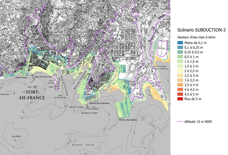
Maximum water height expected in the centre of Fort de France for all tsunamis combined, at a resolution of 2 to 5 metres (Fort de France, 2022)
© BRGM
The need
The island of Martinique is exposed to different types of tsunami, either tectonic or volcanic in origin. Lacking any precise knowledge of this exposure, the Prefecture has defined refuge sites and evacuation routes on the basis of a standard elevation of 15 m throughout the region. To enable the public authorities to base their crisis management decisions on the latest scientific advances, BRGM was asked to acquire new data and produce high-resolution operational maps.
The results
The deterministic approach adopted by BRGM was based on the selection of "credible future scenarios" liable to cause a tsunami on the Martinique coast. Numerical simulations were then developed for all the possible identified scenarios, from generation at sea through to flooding on land.
An initial study conducted in 2017 had already identified the possible impact along Martinique's coastline, at a resolution of 30 metres. Following on from this study, detailed simulations (with a resolution of 2 to 5 metres) were carried out on six town centres considered by the crisis managers as representative of the key situations. For each of these sites, the possible submerged area and the expected height of flooding on land for each of the selected tsunami sources are now known. These results provide a realistic simulation of the flows, taking into account both the possible amplification on the coast due to bathymetric conditions, and the flow obstacles in the urban environment. This study has highlighted the contrasting exposure of Martinique's coasts: the maximum expected run-up exceeds 15 metres in the municipality of La Trinité, while it is only around one metre on the northern Caribbean coast. These maps also provide a more nuanced view of the origin of the tsunamis striking each district.
Using the results
While the general study conducted in 2017 had already clarified the scenarios to be considered at island level (for example, in the ORSEC civil security response plans), the new high-resolution maps provide information at district level. Based on catalogues of scenarios representing all possible situations, each municipality now has the means to identify particularly vulnerable districts of its territory on which to focus prevention and crisis management measures. Lastly, this knowledge can also empower communities with regard to the risk, enabling safeguarding measures to be tailored to the origin of the tsunami. The level of resolution obtained also helps clarify the vulnerability of buildings and refine identification of the most suitable refuge areas.
The partners
- Martinique Environment, Planning and Housing Department (DEAL) and Martinique Regional Authority (CTM)
- Etat-Major Zone Antilles (EMZA) and Interministerial Service for Defence and Civil Protection (SIDPC)
- Martinique Volcanological and Seismological Observatory (OVSM)


