Hydrogeological situation on 1 May 2023
Following a short recharge period of low intensity over the autumn and winter period of 2022-2023, rainfall in March and April led to recharge episodes with a beneficial impact on the areas concerned, for reactive or low-inertia aquifers. Real improvements can be seen in the aquifers of the Armorican Massif, the Channel coast and the Grand-Est region of eastern France. Elsewhere, the rainfall had little impact on trends and on the state of the aquifers.
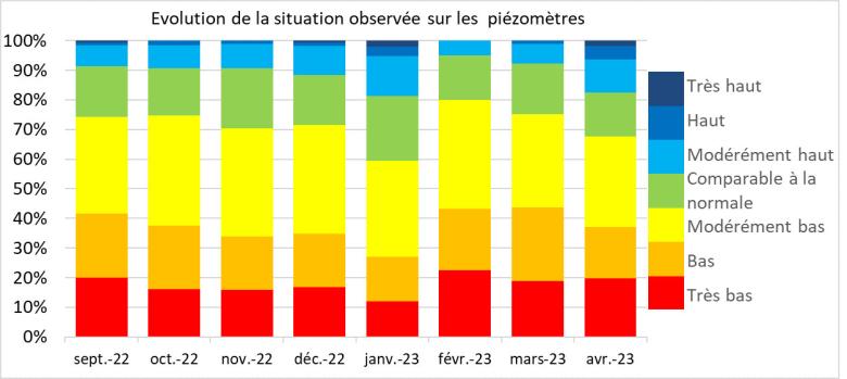
The situation remains unsatisfactory across much of the country: 68% of groundwater levels were still below monthly norms in April (75% in March 2023) with low to very low levels in many areas.
From May onwards, the depletion period is expected to extend to all the aquifers, with levels likely to continue falling until the autumn. Recharge episodes are expected to be occasional and not particularly intense, unless exceptional rainfall episodes occur. Any changes to the state of the aquifers will depend on their reactivity, cumulative local rainfall, evapotranspiration and the demand for water. The situation will need to be closely monitored in aquifers with low water levels, as well as in areas where abstraction demand is particularly high.
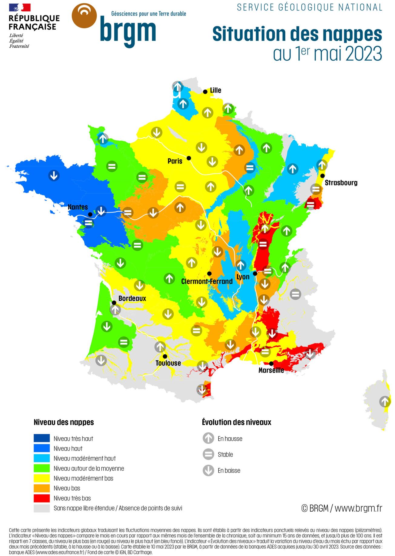
Map of groundwater levels in France on 1 May 2023.
© BRGM
Groundwater trends
The 2022-2023 recharge period was marked by a succession of recharge episodes and dry periods. Rainfall during the autumn and winter was insufficient to recharge the aquifers, owing to the late growth of vegetation and the ground remaining very dry after each episode of drought.
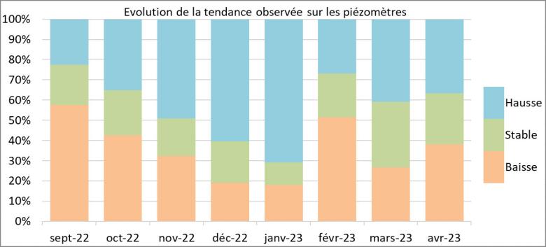
In March and April 2023, cumulative rainfall was in excess over much of France. These rains led to recharge episodes, pushing back the start of the depletion period in areas with the highest rainfall. However, the impact on trends is uneven, depending on the cumulative rainfall and the reactivity of the aquifer: 37% of observation points show higher levels, 25% are stable but 38% continued to fall in April (41%, 32% and 27% in March respectively).
The rains had a beneficial impact on the reactive aquifers in much of northern France. Recharging continued during April for the reactive aquifers of the Grand-Est, Bourgogne-Franche-Comté and the northern part of the Massif Central. In the Armorican Massif, levels are lower or stable following a tail-off in effective rainfall during the last 15 days of April.
The reactions of inertial aquifers in northern France show clear contrasts. Levels are rising in the chalk aquifers of the Artois, and in the east and south of the Paris Basin. In the central Paris Basin area, groundwater levels remain stable or only slightly down, as a result of infiltrated rainfall and low demand for water. Nevertheless, the level of recharging recorded since autumn 2022 remains very low or even non-existent on some piezometers in the centre and south of the Paris Basin.
In southern France, the quantity of rainfall infiltrating at depth has been insufficient or non-existent, and levels are generally falling. The only aquifers where levels are stable or increasing are in the lower Durance and Crau plain, with the reinfiltration of surface water, the Alpine valleys, and the Garonne and its tributaries, replenished by local rainfall or snowmelt.
Situation in relation to April averages
In 2022, the low-water period was severe for most of the aquifers, with recharging levels remaining low during the autumn and winter of 2022-2023. At the end of the winter, the situation of the aquifers was therefore unsatisfactory.
Changes to the situation in April depended on the sensitivity of the aquifer and cumulative local rainfall. The state of the aquifers improved overall, with 17% of observation points being above monthly norms (8% in March). However, 68% of levels remained moderately low to very low (75% in March) while 20% are very low (19% in March). The deficit at the beginning of spring is therefore greater than last year, since 58% of levels were below the norm in April 2022.
In the northern two-thirds of the country, the situation improved considerably in the most reactive aquifers, particularly in the Armorican Massif and Grand-Est region. Levels are generally satisfactory, from moderately low to high. Concerning the inertial aquifers, the rainfall had an impact only on the chalk aquifers most sensitive to effective rainfall in the Paris Basin (Sologne and Sancerre, Burgundy and Gâtinais, Champagne) and on the Artois coast. However, the state of the inertial aquifers remains unfavourable, from moderately low to low, since the recorded inflow has not made up for the extremely low recharge. Only the chalk aquifer of the Artois-Picardy coast shows levels above the monthly norms.
In the southern third of the country, the situation is stable or deteriorating. In the Aquitaine Basin, following a recharge episode in March, depletion continued in April. The situation is deteriorating in the most reactive Cretaceous and Jurassic limestone aquifers. Levels remain unfavourable, from moderately low to normal. Concerning the water tables around the Mediterranean and Rhône-Saône corridor, the situation remains generally stable with a deterioration in some cases between March and April. Levels are unsatisfactory and some are particularly worrying, from moderately low to very low.
Aquifers in a favourable situation
The situation was positive for several aquifers, with levels above normal, compared to April levels in previous years:
- The aquifers of the Armorican Massif basement, from Brittany to the Vendée, benefited from excess rainfall in March and April, so levels are high;
- The levels of the Cenomanian chalk marl aquifer on the Artois-Picardy coast are moderately high, following the excess recharge of 2022-2023;
- The situation of the Vosges sandstone, Triassic limestone, Jurassic limestone and Albian sand aquifers of the Grand-Est region improved considerably during April, with levels now comparable to normal or even high.
Aquifers in an unfavourable situation
Many aquifers are in an unfavourable situation with very low levels compared to April of previous years, owing to an extreme rainfall deficit in recent months:
- The levels of the inertial aquifers from the Dijon area to Bas-Dauphiné are low to very low, owing to the low intensity of several successive winter recharges;
- The aquifers of the Roussillon multi-layer aquifer are in an unprecedented situation, with low levels in the deep Pliocene aquifer and very low levels in the surface aquifer. Some points in the surface water are at historically low levels, with a high risk of saltwater intrusion;
- The levels of the coastal alluvial aquifers and karst limestone aquifers of Provence and the Côte d'Azur are low to very low, or even historically low.
Comparison between 1 May 2022 and 1 May 2023
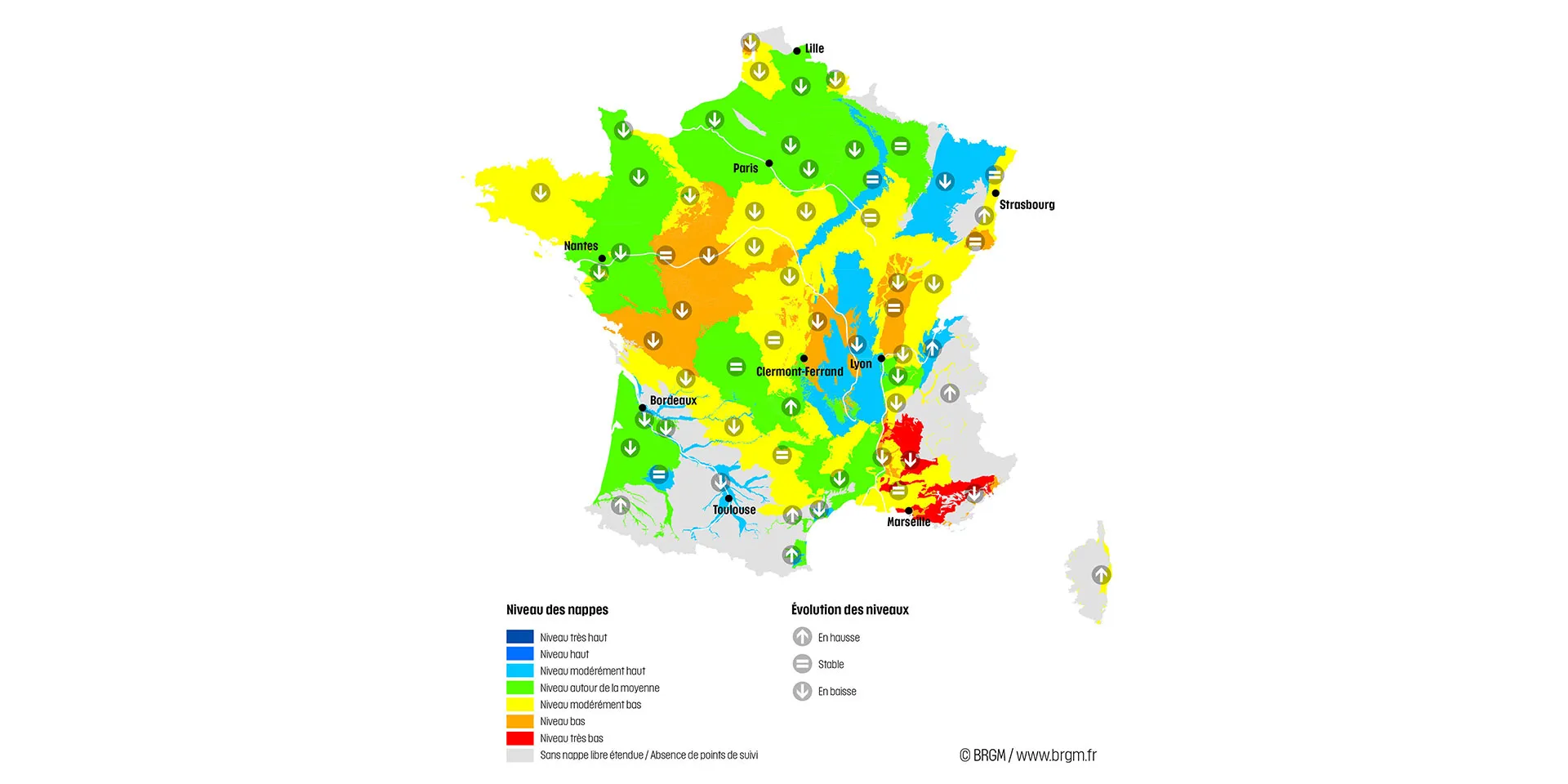
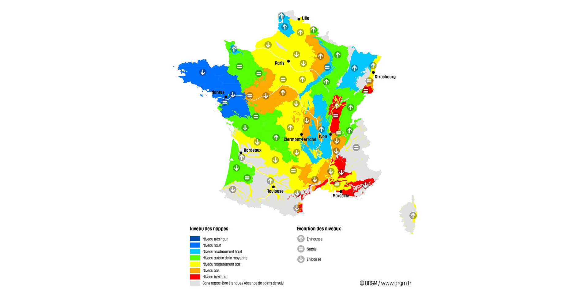
Map of France showing the state of the aquifers on 1 May 2022 (left) and 1 May 2023 (right).
© BRGM
Forecasts
Météo-France forecasts for May, June and July do not suggest any particular scenario for rainfall, but temperatures are expected to be higher than normal across France. High temperatures could contribute to an increase in water abstraction and the amount of water required by vegetation.
Over the next few months, the deep infiltration of rainfall will be limited. Recharge episodes are expected to be occasional, local and of low intensity. An improved groundwater situation with higher water levels will require significant rainfall, wet soil and a reactive groundwater table. The demand for water resources through abstraction may also influence the state of the aquifers. Finally, the poor snow cover in mountain ranges is unlikely to maintain the levels of aquifers that are sensitive to snowmelt during the spring.
In May, if rainfall is insufficient, the process of depletion will probably affect all aquifers. Levels are then likely to remain low, and the situation is expected to deteriorate, rapidly in the case of the most reactive aquifers and those most affected by abstractions, and slowly in the case of inertial and little-used aquifers.
Rainfall in May is not expected to recharge the inertial aquifers, except in the event of exceptional rainfall. In the case of reactive aquifers, significant rainfall events could infiltrate deeply, maintaining or even occasionally increasing water levels. The situation could then improve locally. However, any deep infiltration will be limited in the case of dry soil, as the water will moisten the soil and meet the water needs of vegetation. Rainfall in May could also limit the excessive abstraction of groundwater, particularly for irrigation.
Drought risk planning map - update
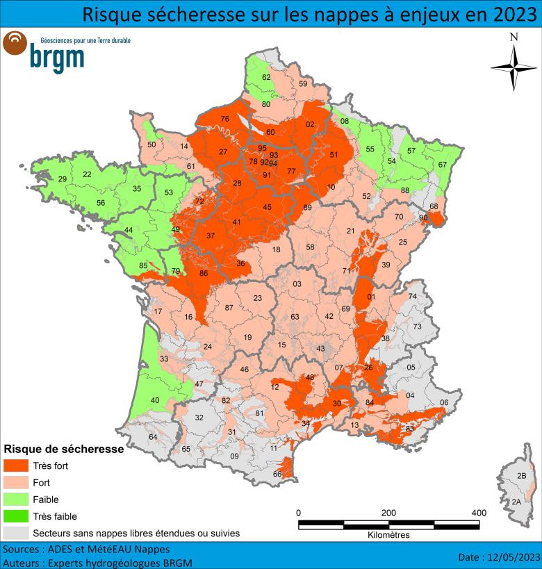
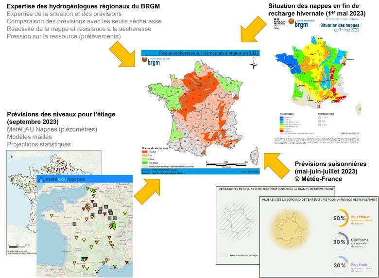
Forecasts for the summer of 2023 are generally pessimistic, with a high to very high risk of drought for most aquifers. The aquifers experienced an extreme low-water period in October-November 2022, with a recharge deficit in the autumn and winter of 2022-2023. Only the aquifers benefiting from excess recharge, particularly in late winter and early spring 2023, show a low risk.
More specifically, no aquifers show figures that would guarantee satisfactory levels until the autumn. The "very low" (dark green) level of risk therefore does not appear on the map.
The "low risk" sectors (light green) are areas with reactive aquifers that benefited from excess rainfall at the end of winter and beginning of spring 2023, and where levels were relatively satisfactory in April: aquifers in the Grand-Est, the Channel coast, the Armorican Massif and the west of the Aquitaine Basin These late recharge episodes have considerably improved the state of the aquifers and pushed back the start of the depletion period. However, a high level of uncertainty remains concerning the absence of drought. In a situation of insufficient rainfall and with high temperatures drying out the soil, the demand for water could be significant. Local tensions could then arise around aquifers that are not resistant to drought or basins that are heavily used.
The risk of groundwater drought is considered to be “high” (light red) across a significant part of France. The lack of rainfall in 2022 had a strong impact on these aquifers, with recharges in 2022-2023 being insufficient to sustainably replenish groundwater reserves. In the case of reactive aquifers (Massif Central basement, Jurassic limestone of the Jura, Côte-des-Bars, Berry, Charentes, Périgord and Causses du Quercy, alluvial deposits of the Alps, lower Rhône and Adour), levels this summer will depend mainly on the rainfall over the coming weeks. Abundant rainfall could ensure that levels are high enough to avoid water restrictions. However, the impact will be temporary and the situation could deteriorate rapidly over the summer in the event of prolonged drought and high demand for groundwater. In the case of inertial aquifers (Artois-Picardy chalk, alluvial and tertiary formations of the southern Alsace plain, Limagne, Savoyard foreland, Bas-Rhône and Durance, Corsica, Garonne and Armagnac, and volcanic formations of the Massif Central), the risk will depend primarily on water demand during late spring and summer. Local rainfall is expected to have little impact on the aquifers.
The "very high" (dark red) risk of drought reflects a worrying situation, with probable tensions during the spring and summer. This risk is confirmed for the alluvial and tertiary aquifers around the Mediterranean, the karst limestone aquifers of Provence, the Grandes Causses and the Cévennes border, the tertiary aquifers of the Rhone corridor and the Sundgau, the Cenomanian sand, Seno-Turonian chalk and tertiary aquifers of the Paris Basin, and the Jurassic limestone aquifers of the Brenne and Poitou regions. For these aquifers, the recharge deficit is unlikely to be made up, since levels are too low in reactive aquifers (alluvium and limestone) and the recharge period has ended in inertial aquifers (tertiary formations, chalk and Cenomanian sand). Restrictions on groundwater use are already in place in some areas and are likely to be implemented in others this year. It seems possible too that these aquifers will no longer be able to play a role in replenishing low water levels over the summer.
How was this map made?
The drought risk map for aquifers was drawn up by BRGM regional hydrogeologists in early April 2023 and updated in early May 2023. This risk of drought concerns levels that are expected to be low, very low, or below alert thresholds in August-September 2023, leading to restrictions on the use of water. Note that this national map shows overall situations and does not reflect local disparities.
BRGM's expert appraisal is based on the initial state of the water table after the 2022-2023 winter recharge period, on seasonal forecasts for temperature and rainfall from Météo-France and on available forecasts concerning aquifer levels through to September 2023, based on grid-based or global hydrogeological models (MétéEAU Nappes). The dynamics of the aquifer, its sensitivity to drought, and the pressure on water resources are also taken into account in determining the level of risk.
Through this work, we are able to issue alerts on the risk of groundwater restrictions during the summer period. The results were compiled for each department by the Ministry of Ecological Transition in order to produce a drought risk map for all water resources.
State of groundwater: monitoring by BRGM
Groundwater is a widely used resource: in metropolitan France, it accounts for nearly two-thirds of drinking water consumption and more than one-third of agricultural water consumption. It is also widely used in the industrial sector. Groundwater tables depend on cyclical recharges.
BRGM monitors groundwater levels and quality in mainland France. Discover the actions carried out by the French geological survey and the resources and databases available on groundwater in France.
Press contact




Map drawn up by BRGM on 10 May 2023, based on data from the ADES database, acquired up to 30 April 2023. Data source: ADES database / Map background © IGN, BD Carthage.
This map shows the global indicators reflecting the average fluctuations of the aquifers. They are based on point indicators collected at groundwater level monitoring points (by means of piezometers).
The "Aquifer levels" indicator compares the current month’s figures with those of the same months in the entire record, i.e. at least 15 years of data and sometimes up to as much as 100 years of data. It is divided into 7 classes, from the lowest level (in red) to the highest (in dark blue).
The grey areas correspond to areas without unconfined aquifers, i.e. with an impermeable or semi-permeable layer above the aquifer, and/or sectors with a very low density of measuring points. This last case primarily concerns mountainous areas with small, heterogeneous aquifers.
The "Evolution of levels" indicator reflects the variation of the water level of the past month compared to the two previous months (stable, increasing or decreasing).
These global indicators reflect general situations and trends and do not take into account possible local disparities.