Hydrogeological situation on 1 April 2023
After several weeks without effective rainfall, the rainfall in March led to recharge episodes in the most rained-on areas, particularly in the west of France. However, this rainfall had little impact on the state of the aquifers. The situation remains unsatisfactory for much of the country: 75% of aquifer levels remain below monthly norms (58% in March 2022) with many areas showing low to very low levels.
From April onwards, recharge episodes will probably be occasional and not particularly intense, unless there are exceptional rainfall episodes. For the next few months, the 2022-2023 recharge deficit is likely to affect all the aquifers. Many areas are at risk of drought during the summer period. However, uncertainty remains high for some aquifers, as abundant rainfall during the spring could help to sustain levels or even restore them to satisfactory levels.
A new, more accurate and clearer map of the groundwater situation
In April 2023, the format of the monthly aquifer situation map, published 10 times per year by BRGM, will change. With two objectives:
- to add more precise information to the “Groundwater level” indicator, by representing the geographical extent of each aquifer by a coloured flat area instead of the symbol used in the previous version;
- to clarify the symbolism used for the “Evolution of levels” indicator: an arrow pointing up or down or an equal sign to represent respectively the recharging, emptying and stable aquifers.
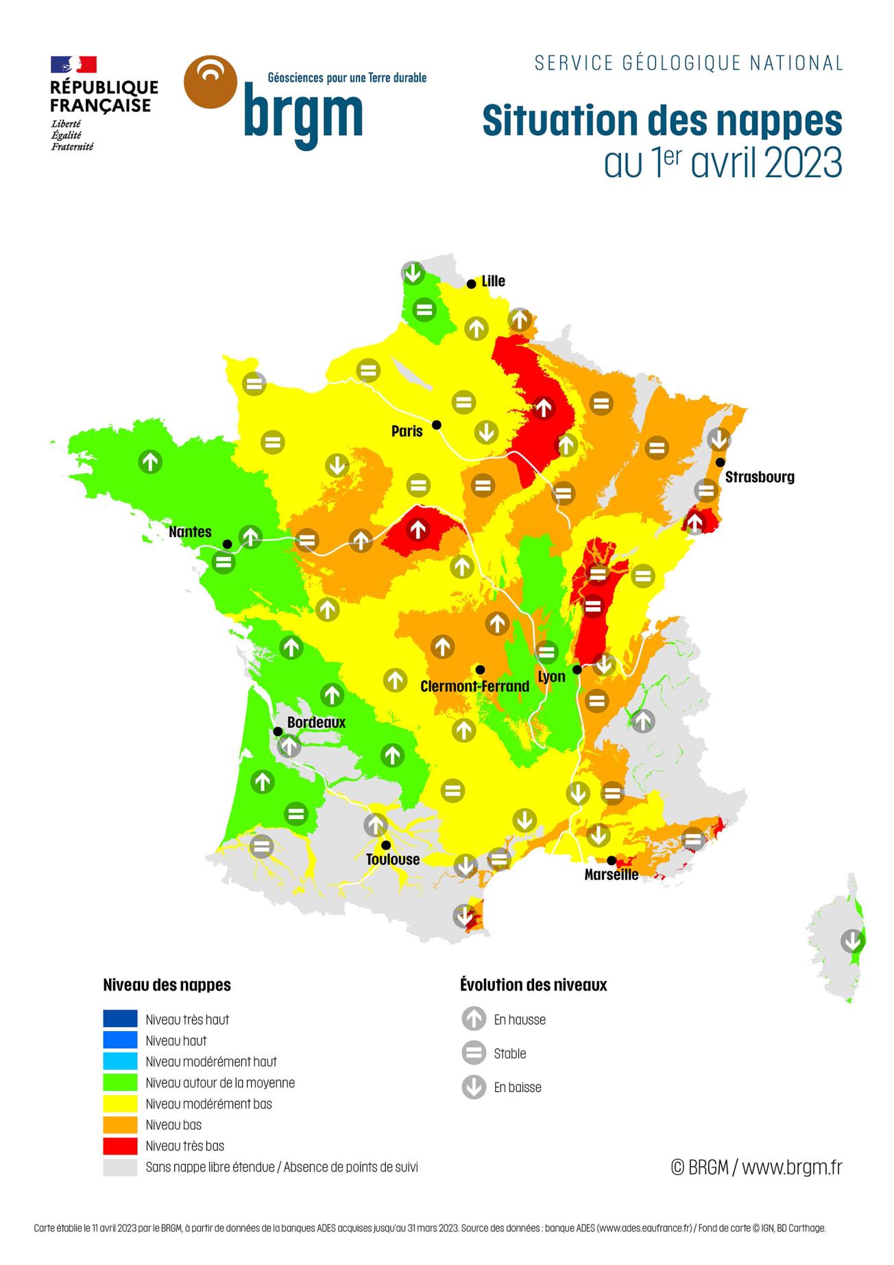
Map of aquifer levels in France on 1 April 2023
© BRGM
Groundwater trends
The 2022-2023 recharge period was marked by a succession of recharge episodes and dry periods. The trends slowly reversed in the autumn of 2022. This is due to the low amount of rainfall that infiltrates deeper, due to very dry soils and late vegetation-growth. In December 2022 and January 2023, recharging continued with levels increasing overall. The end of the winter of 2022-2023 was marked by a strong deficit of effective rainfall and February 2023 was characterised by falling levels.
In March, the accumulated precipitation was in excess over a large part of the country. However, the impact on aquifers is heterogeneous: 41% of observation points show higher levels, 32% are stable but 27% remain down. The rain first moistened the dry soils and was then used by the vegetation to emerge from its dormancy before the remainder managed to infiltrate deeply.
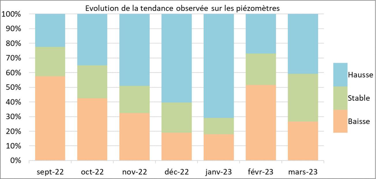
Evolution of the trends observed on piezometers from September 2022 to March 2023.
© BRGM
There was an impact on reactive aquifers in the areas that had the most precipitation. Levels thus rose in the basement aquifers in the south of the Armorican Massif and in the north and west of the Massif Central, in the Jurassic and Cretaceous limestone aquifers of Berry, Vendée, Périgord and the Causses du Quercy, in the Aquitaine Plio-Quaternary aquifer and in the alluvial aquifers of the Garonne, the Dordogne and their main tributaries. Elsewhere, the rainfall that infiltrated deeply was insufficient to compensate for the depletion through natural outlets, and levels are stable or still falling.
For the inertial aquifers of the Paris Basin and Artois, the recharge period began in December-January and appeared to end in February. The March rains allowed recharging to continue in the chalk aquifer in in the Artois-Picardy, Champagne and Touraine basin. Levels have also stabilised in the inertial aquifers of the central Paris Basin. However, the recharge recorded since autumn 2022 remains very low or even non-existent in some piezometers in the centre and south of the Paris Basin.
As regards the inertial aquifers of the Rhône-Saône corridor, the recharging took place in November 2022. It was very weak and seems to have stopped early, between February and March. Thus, March levels are either stable or decreasing.
The situation in relation to March averages
Rainfall deficits recorded in the 2021-2022 hydrological year and intense abstraction of groundwater in the spring and summer of 2022 led to severely low levels in most aquifers. The situation during the autumn and winter of 2022-2023 did not change much, as there was very little recharging. Only in January was there a clear improvement in the state of the aquifers, before a sharp deterioration in February. The recharge from rains during March was not sufficient to bring about a clear improvement.
Recharge episodes in the autumn of 2022 and winter of 2022-2023 remained largely insufficient to make up for the deficits accumulated during this last hydrological year. As a result, all aquifer levels are lower than normal and 75% of the measuring points show moderately low to very low levels. The situation at the end of winter is more deficient than last year (with 58% of levels below average in March 2022).
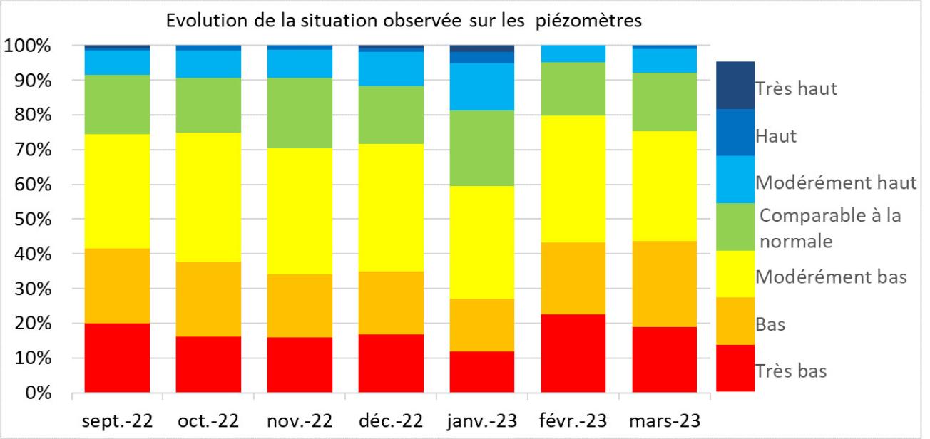
Evolution of the situation observed on the piezometers from September 2022 to March 2023
© BRGM
For the reactive aquifers, the situation generally remained stable or deteriorated between February and March. Their levels remained below monthly averages, from moderately low to very low. Only the aquifers from Brittany to New Aquitaine benefited from significant recharge episodes during March, which considerably improved the situation and restored levels that are comparable to normal.
As regards the inertial aquifers in the north of France and in the Rhône-Saône corridor, the situation has not changed much since the beginning of autumn. During March, it deteriorated in areas that had not received sufficient rainfall in recent months. The levels remain unsatisfactory and some are of concern, from moderately low to very low.
The situation was favourable for several aquifers, with levels close to normal, compared to March levels for previous years:
- The Armorican Massif basement aquifer benefited from highly excessive rainfall in March, which led to recharges in the last two weeks of the month;
- There was a clear improvement in the condition of the Jurassic and Cretaceous limestone aquifers in the south of the Vendée, the Périgord and the Causses du Quercy following effective recharge in March;
- The Aquitaine Plio-Quaternary aquifer recorded a marked recharge in March in the north and a weaker one in the south.
Many aquifers are in an unfavourable situation, with levels that are extremely low compared to the situation observed in March in previous years:
- The levels of the inertial Champagne chalk aquifer, despite rising levels in March, are very low as a result of a recharge deficit;
- The inertial aquifers of the Rhône-Saône corridor show low to very low levels, due to the low intensity of several successive winter recharges;
- The Roussillon multi-layer aquifers are experiencing an unprecedented situation since the introduction of management thresholds, with low to very low levels for March, due to the extreme lack of rainfall in recent months;
- The coastal alluvial aquifers and karst limestone aquifers of Provence and the Côte d'Azur have low to very low levels, and there are even historically low levels in the Var.
Forecasts
The forecasts from Météo-France for April, May and June do not suggest any particular scenario for more rainfall, but higher than normal temperatures along the Mediterranean coastline and in Corsica.
From April on, the rise in temperatures, the regrowth of vegetation and therefore the increase in evapotranspiration will significantly reduce the amount of rainfall that filters through to the aquifers. April trends will then depend on these factors, but also on the volumes abstracted. The poor snow cover in the mountain ranges is unlikely to sustain the levels of aquifers that are sensitive to winter melt, during the spring.
If there is insufficient rainfall, the depletion will probably affect all the aquifers during April. The downward trend in levels would then continue until the autumn. As a result, the situation should deteriorate, rapidly in the most reactive aquifers and those most affected by abstractions, and slowly in the inertial and little exploited aquifers. In the absence of rain and with high temperatures, the early start of irrigation campaigns could also affect the aquifers.
However, weather fronts might cross France. Rainfall is not expected to recharge the inertial aquifers unless volumes are exceptional. Significant rainfall events may cause momentary recharges, allowing levels to be sustained or even, very occasionally, to rise. The situation could then improve locally. It should be noted that spring rains might delay the start of the depletion period for reactive aquifers and avoid excessive use of groundwater, particularly for irrigation.
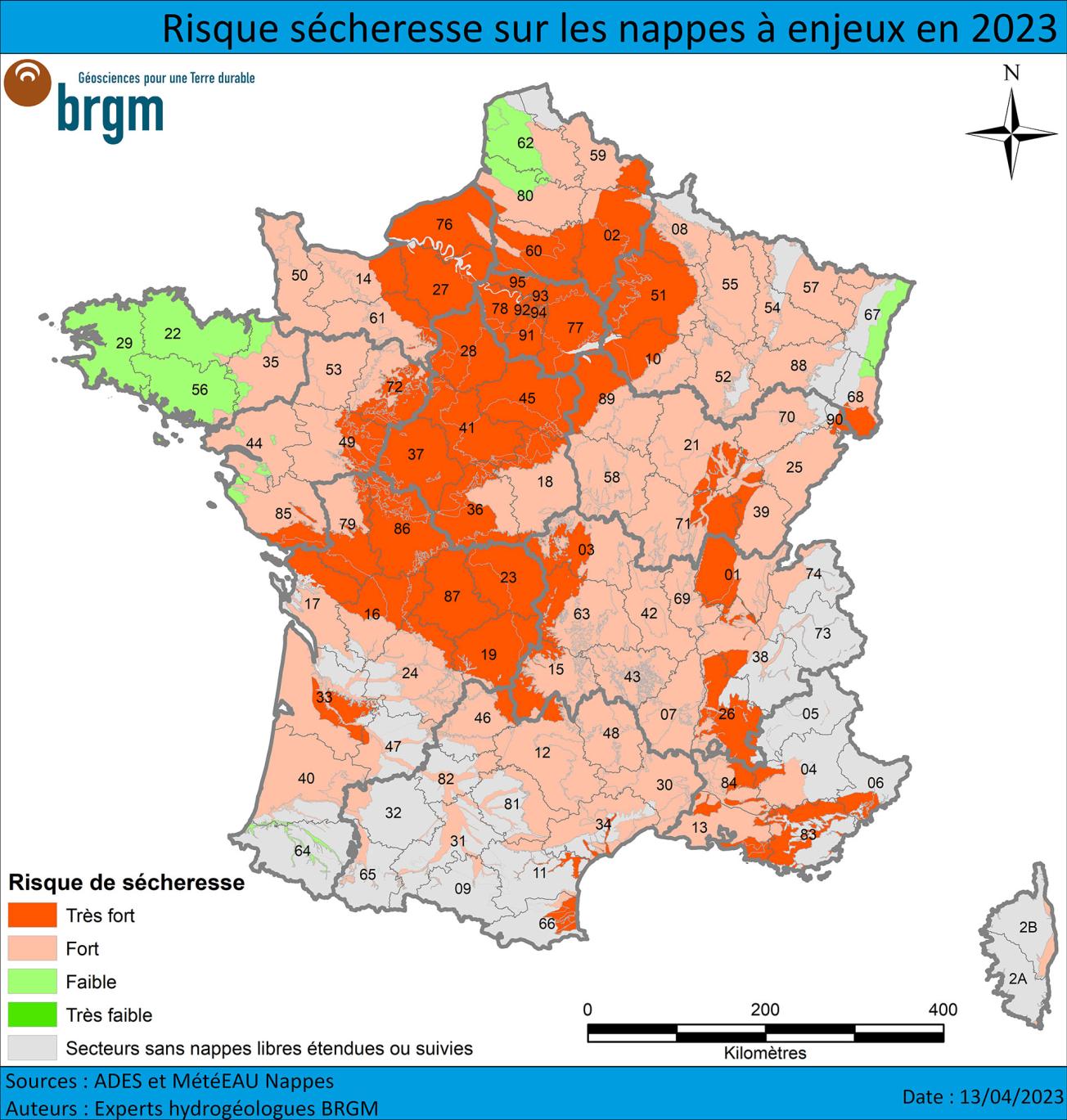
Risk of drought affecting strategically important aquifers in 2023 - April 2023.
© BRGM
If the depletion period does occur in April, the recharge period will have been short and not very effective for most of the aquifers, which could lead to difficult situations as early as spring. A drought risk anticipation map for the summer of 2023 has been published by BRGM hydrogeological experts, based on a rainfall scenario varying from close to normal to pessimistic. This risk of drought is defined by low to very low levels (with a recurrence frequency of less than 5 years) or by levels below the alert thresholds, leading to the issuing of orders to restrict the use of water during the spring and summer periods.
The “very high” drought risk reflects the problematic current situation, with moderately low to very low levels in March, and indicates that the situation in spring and summer is likely to be difficult. If there is no significant excess rainfall during the spring and summer, groundwater restrictions are likely to be introduced in 2023.
The “high risk” areas have aquifers whose levels are close to or below March averages. This summer's levels will depend mainly on the amount of rainfall in the coming weeks. Abundant rainfall could ensure that levels are high enough to avoid water restrictions.
“Low” risk concerns aquifers for which relatively satisfactory levels are currently being recorded. However, uncertainty about whether or not there will be a drought remains high. If the spring and summer of 2023 are similar to 2022, with no rainfall, high temperatures and high water demand, the levels of these aquifers could drop significantly.
None of the aquifers had above normal levels in March, which would have ensured satisfactory levels until the autumn. The “very low” risk is therefore not shown on the map.
Note that the map of the risk of drought has been updated to 1 May 2023.
State of groundwater: monitoring by BRGM
Groundwater is a widely used resource: in metropolitan France, it accounts for nearly two-thirds of drinking water consumption and more than one-third of agricultural water consumption. It is also widely used in the industrial sector. Groundwater tables depend on cyclical recharges.
BRGM monitors groundwater levels and quality in mainland France. Discover the actions carried out by the French geological survey and the resources and databases available on groundwater in France.
Press contact




Map drawn up by BRGM on 11 April 2023, based on data from the ADES database, acquired up to 31 March 2023. Data source: ADES bank / Map background © IGN, BD Carthage.
This map shows the global indicators reflecting the average fluctuations of the aquifers. They are based on point indicators collected at aquifer-level monitoring points (by means of piezometers).
The “Aquifer levels” indicator compares the current month’s figures with those of the same months in the entire record, i.e. based on at least 15 years of data and sometimes up to as much as 100 years of data. It is divided into 7 classes, from the lowest level (in red) to the highest (in dark blue).
The grey areas correspond to areas without unconfined aquifers, i.e. with an impermeable or semi-permeable layer above the aquifer, and/or sectors with a very low density of measuring points. This last case primarily concerns mountainous areas with small, heterogeneous aquifers.
The "Evolution of levels" indicator reflects the variation of the water level of the past month compared to the two previous months (stable, increasing or decreasing).
These global indicators reflect general situations and trends and do not take into account possible local disparities.