A strong earthquake occurred on 16 June 2023 at 6.38pm, 11 km north of Surgères and 35 km east of La Rochelle. The moment magnitude was estimated at between 4.8 and 4.9 according to the Côte d'Azur Observatory (OCA) and the Institut de Physique du Globe de Paris (IPGP). The earthquake was felt across much of western France, from Bordeaux in the south to Caen in the north, and as far east as Clermont-Ferrand. Several aftershocks have been recorded to date, with the two biggest occurring on 17 June at 04:27 am and 09:31 am. The teams sent in by the Institut Terre et Environnement in Strasbourg and the German Research Centre for Geosciences were able to determine the hypocentre mechanisms in order to characterise the source: the results show a strike-slip movement illustrated by shearing along a subvertical fault.
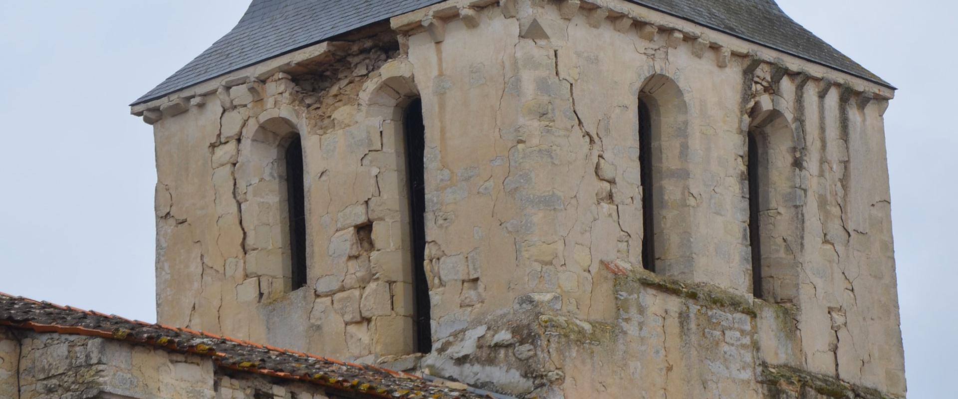
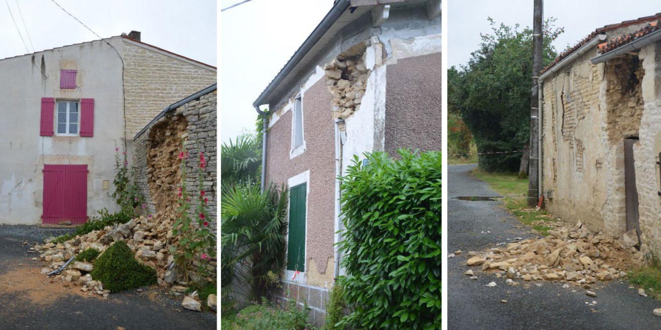
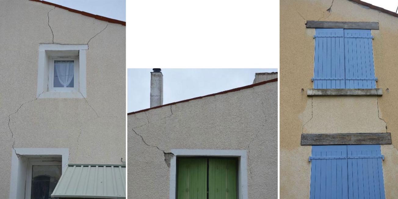
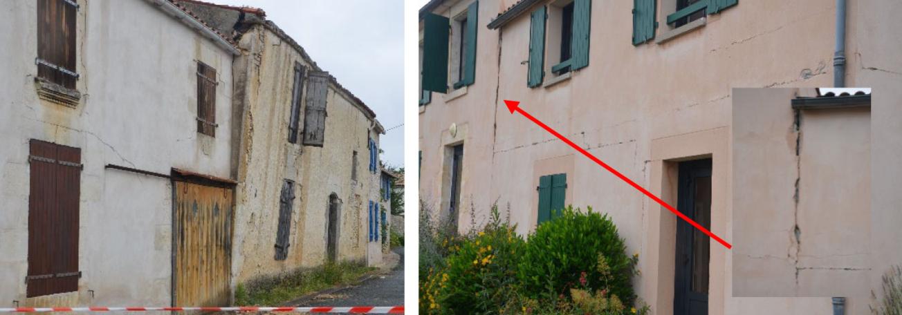
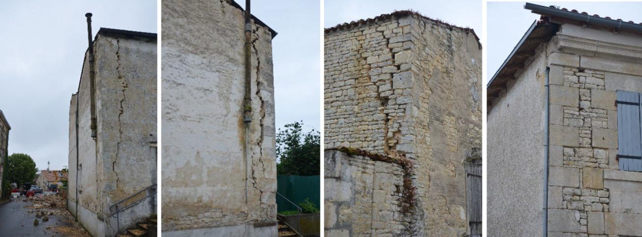
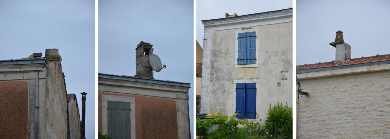
The relatively high magnitude of the earthquake, combined with the shallow depth of the hypocentre, estimated at just 3 km by the BCSF-RéNaSS (French Central Seismological Bureau - National Seismic Surveillance Network), resulted in strong tremors in the epicentral region, currently estimated at VI in the preliminary findings by BCSF-RéNaSS on the 12-point Mercalli Intensity Scale. This level of intensity corresponds to the level from which moderate damage can be seen on the most vulnerable buildings. Feedback from the field shows damage in the epicentral zone around the village of La Laigne in Charente-Maritime.
The scientific community immediately set to work, deploying a range of instruments from 17 June in the epicentral zone through the French Seismological and Geodesic Network (Résif) in order to record the aftershocks and improve our understanding of this ongoing phenomenon.
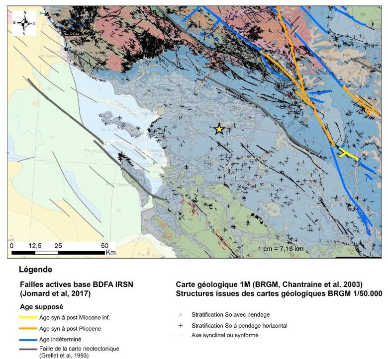
Geological context of the earthquake in La Laigne (yellow star). Location of potentially active faults according to the IRSN BDFA (database of active faults) (Jomard et al., 2017) and of the tectonic structures listed on geological maps on a scale of 1/50000 (BRGM).
© BRGM - geological map on a scale of one millionth / Chantraine et al., 2003
Geological and seismotectonic context
The region affected by the earthquake lies on the northern edge of the Aquitaine basin, south of the southern Armorican massif. More precisely, it corresponds in part to the catchment area of Sèvre Niortaise and forms the southern edge of the Poitevin marshes. The epicentral zone is located approximately halfway between La Rochelle (Charente-Maritime) and Niort (Deux-Sèvres).
The subsoil consists of a sedimentary layer of marl and clay limestone around 150 to 200m thick, dating back to the Jurassic age (between 175 and 150 million years ago approximately), with slight folds facing SSW. This limestone rests on a bedrock of metamorphic rock (micaschists, gneiss) and volcano-sedimentary rock dating back to the Cambrian age (around 500 million years ago). This ancient bedrock outcrops around 30 km to the north, forming the relief of the southern Armorican Massif. These formations are covered locally by at least 2 to 10 metres of clay (mainly illite and kaolinite) of fluvio-marine origin, deposited 19,000 years ago when sea levels rose in the hollows of the Poitevin marshes. This layer of surface clay may have created a site effect, amplifying the seismic movement. This point needs to be verified and quantified by in-situ measurements.
The current structure of the southern Armorican massif and the northern edge of the Aquitaine Basin is the legacy of several successive geodynamic events:
- the Hercynian orogenesis that created the relief of the Armorican Massif (~290-420 Ma);
- the opening of the Bay of Biscay (~150-84 Ma);
- the convergence of the Iberian and Eurasian plates over the last 90 Ma, creating the Pyrenees and the Alps (50 Ma to the present day).
The bedrock of the Hercynian chain, forming the Armorican Massif that is now eroded, extending under the sedimentary overburden of the Aquitaine Basin. The same is true of the main faults, which can be traced from Brittany to the Limousin. The main faults run primarily NNW-SSE to NW-SE, such as the Cholet-Bressuire-Oradour-sur-Glane fault running NW-SE, which is 170 km long but segmented by other faults, and the Parthenay fault running NNW-SSE. Other fault segments run WNW-ESE to WE, identified on the Charente coast and offshore.
These Hercynian faults are pre-existing discontinuities that have been reactivated over the course of geological time by various geodynamic events (see the results of the Convergence and RGF Pyrenees projects). Some of these major faults are still active today, with a movement that is predominantly strike-slip (more locally reverse or normal), in response to the NS to NW-SE compressive regime caused by the convergence of the African plate towards the Eurasian plate. In the epicentral area, this is the case of the Surgères-Blanzay-Aulnay-Échelle fault mapped SE of the epicentre. This structure, which is probably strike-slip, has been mapped in (albeit uncertain) segments intersecting with the Jurassic formations from Mauzé-sur-le-Mignon, extending possibly to the bedrock in Corrèze.
The reactivation of these bedrock faults can sometimes propagate to the surface, intersecting recent overlying sedimentary deposits. At depth or near the surface, these reactivations can lead to earthquakes.
Although the geodynamic context is generally well known with respect to the plates, we do not have sufficient geological knowledge of the subsoil in Charentes Maritimes and neighbouring regions (land and sea) to be able to associate this earthquake with a known tectonic structure. In this region of historical seismic activity, BRGM initiated onshore and offshore studies in collaboration with several universities a few years ago in order to expand existing knowledge of the structural map. However, more targeted investigations are needed, along with data acquisition (structural, geophysical, geomorphological, etc.) on a local scale in order to understand the context of the La Laigne earthquake.
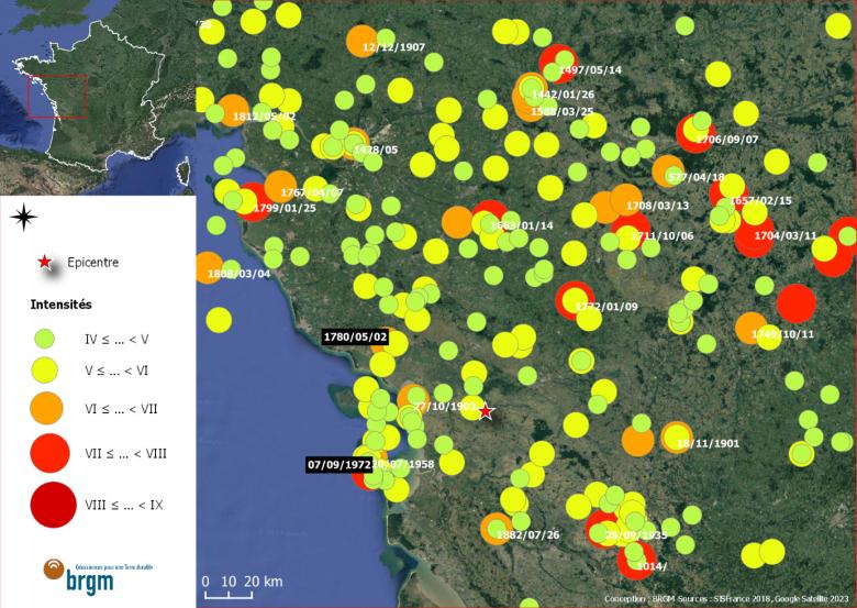
Map of historical earthquakes from the SisFrance database in the region of the La Laigne earthquake (16/06/2023).
© SisFrance
Historical seismicity
This is a region of moderate seismicity, associated with the reactivation of a system of inherited tectonic structures described above. It has seen a number of historical events, the most serious of which have led to damaging effects. The main events listed in this region are: the 1972 earthquakes on Île d’Oléron (moment magnitude Mw 5.0, epicentral intensity I0 = 7), the 1772 earthquake in Parthenay (Mw 5.7, I0 = 7.5), the 1780 earthquake near Luçon (Mw 5.1, I0 = 6.5) and the 1835 earthquake in Haut Poitou (Mw 4.7, I0 = 6). The estimated moment magnitudes (Mw) are taken from the article by Manchuel et al. (2018) and the epicentral intensities based on I0 from the Sisfrance catalogue (BRGM/EDF/IRSN, www.sisfrance.net). These historic events, which are emblematic of the region's seismogenic potential, are distributed over a perimeter of some fifty kilometres around the epicentral zone. Like the earthquake of 16 June 2023, these events are associated with the distribution of macroseismic intensities indicating damage in the epicentral zone.
The 1972 Oléron earthquakes and the 1780 Luçon earthquake appear to have been comparable to the earthquake of 16 June 2023, in terms of magnitude (Mw 4.9 to 5.1), epicentral intensity (I0 = 6 to 7) and distribution of macroseismic intensities.
More locally, around the epicentre of the earthquake of 16 June 2023, more moderate historical events have been recorded. For example, the earthquake of 5 April 1950, which had a moment magnitude of Mw 3.4 and an epicentral intensity of I0 = 5. This illustrates the fact that events similar to those with a magnitude of 5 or higher, as described above, can occur in this area, with its distributed seismicity and old inherited structures.
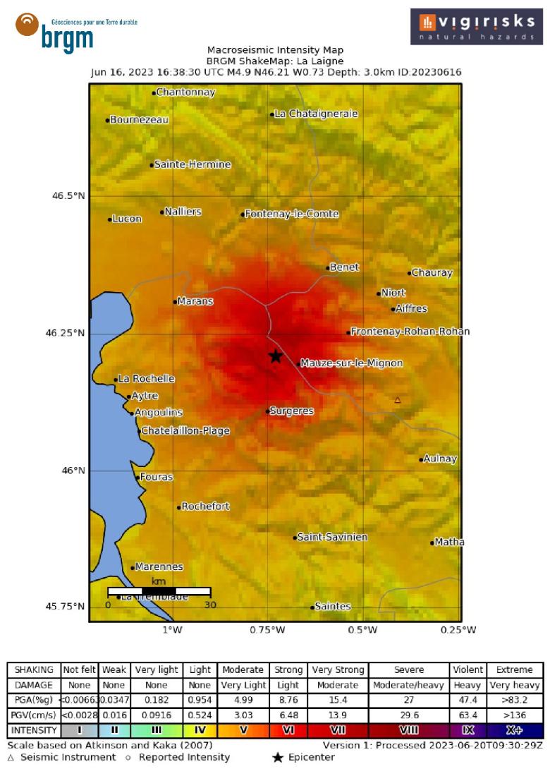
Map of EMS-98 intensities generated by Shakemap using BCSF-Rénass earthquake parameters and data from the two Résif seismological stations, CHIF and UNIO.
© BRGM
Shakemaps and damage scenarios
A shakemap (map of significant ground movements) and damage scenario have been produced by BRGM using the platform Vigirisks. This work is based on the earthquake parameters (latitude, longitude, depth) provided by RéNaSS and a magnitude Mw of 4.9 supplied by OCA and GFZ, as well as real-time data from the Résif seismological stations, CHIF and UNIO. The shakemap was produced with the ShakeMap 4.0 software from USGS, using default site effect mapping (slope-based proxy). We obtained a maximum intensity of VII, in line with the macroseismic effects observed on the ground – particularly in the La Laigne area – suggesting an intensity of VI or higher. This preliminary shakemap also shows strong tremors (VI or higher) within a radius of some 20 km, suggesting damage concentrated around the epicentre. Note that this shakemap does not take account of the preliminary estimates of intensity calculated by the BCSF on the basis of online macro-seismic reports, and that it uses a global attenuation model that will no doubt have to be adjusted to the local context.
Damage estimates were produced using the Vigirisks tool, based on the shakemap described above and the description of the exposed buildings resulting from work carried out in collaboration with the CCR. The results below indicate degree D3 damage based on the EMS-98 scale. This level corresponds to significant to substantial damage, with moderate structural damage and heavy non-structural damage. However, estimates show a low probability of D4 and D5 damage (heavy to very heavy structural damage). These statistical results are shown for individual municipalities, with the purpose of providing an order of magnitude of the damage and estimating the extent of the area affected as well as the number of municipalities affected.
Damage observed
In pictures: 9 questions about earthquakes
To find out more
-
Download the full status note and references(PDF, 3 MB)
-
Earthquake with a magnitude of 5.3 near Niort - Franceseisme.fr (unistra.fr)
-
Earthquake in La Laigne - Preliminary macroseismic intensities and information
-
Earthquakes in La Laigne: a busy weekend for the Terre Solide community
-
Fact sheet on the earthquake in western France on 16 June 2023 - IRSN



These maps show the main fault structures (thin black lines), as well as the geological formations, from the oldest to the most recent: Hercynian bedrock (red, brown), Cretaceous (green), Jurassic (blue), Tertiary (orange/yellow).