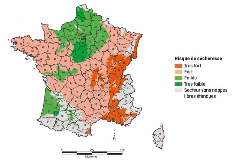
Predictive map of the risk of drought on important aquifers, extrapolated from the Hydrological Situation Bulletin (BSH) and MétéEAU Nappes.
© BRGM
This is a topical issue in the context of global warming. There is a growing demand from local authorities and manufacturers for decision support tools in this area. The problem is even more crucial for France, since groundwater accounts for almost two thirds of the drinking water consumed, and about one third of the water used in agriculture.
Of course, this resource is already monitored on a daily basis by BRGM, via its piezometric network of 1,600 wells spread over mainland France and the French overseas territories. The hydrogeological groundwater situation bulletin published by EauFrance (BSH nappes), provides a monthly map of the state of the groundwater levels based on monitoring data reported in real time.
Moving from monitoring to forecasting groundwater levels
But this is not sufficient for forecasting, as it only gives the state of the aquifers at a given moment. As an extension of the BSH, BRGM teams have therefore developed a new forecasting tool, this time for predicting the evolution of water tables: MétéEAU Nappes The website went live in early 20211. It shows the state of the resource at a given moment and in real time, following the same methodology as for the BSH. In addition, visitors to the site can view forecasts based on climate scenarios.
Modelling adapted to each aquifer
Technically, MétéEAU Nappes is a platform, which both collects data and is open to the outside world through an Application Programming Interface (API) system to provide input for and exchange with professional services.
MétéEAU Nappes displays the situation of groundwater levels on the current date, but also their future evolution. The new tool is based on the Standardised Piezometer Indicator (SPI) calculation service for both real-time and forecast data.
In order to make statistical assumptions, the points studied must be based on data that have been known for at least 15 years. Moreover, as the functioning of aquifers varies in France, each specific groundwater point integrated in MétéEAU Nappes is modelled before being integrated into the website.

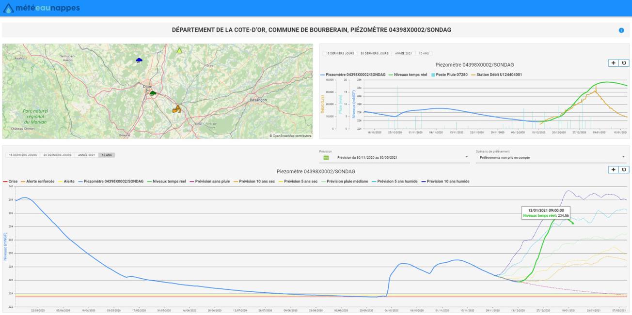
Example of graphic visualisations of readings and predictions on a specific point on the MétéEAU Nappes website.
© BRGM
A support tool for decision-making and various services
This platform is therefore a groundwater management tool. It is primarily intended for government departments and local authorities in charge of allocating water to users. More broadly, it serves managers, manufacturers, engineers and forecasters in the regions. It responds to a growing demand for assistance in managing the resource.
The site offers several levels of access depending on the expertise of the users: the general public, but also professionals with reserved access levels. Some fifteen points are currently listed; the map is to be completed and the tool, which is evolving, should make it possible to integrate new services very soon.
MétéEAU Nappes thus offers a set of useful tools for the management of low water levels and the risk of flooding by rising water tables, such as the display of the situation of the water tables and their forecast levels. Real-time collection and dissemination of groundwater data makes it automatically available on a daily basis. The most recent surface water and rainfall data are also included. This information is dynamically refreshed at each login date. The platform is above all a decision support service for water management, with a possible automatic monthly refresh of the proposed predictive data for the following six months.
Potential customers include government departments to enable them to anticipate and define water use restriction orders, public or private managers, Regional Directorates for Environment, Planning and Housing (DREALs), water agencies, regions, départements, Public Regional Basin Authorities (EPTBs), municipalities, design offices, producers, etc. plus all agricultural stakeholders, so that they can better anticipate, optimise and manage irrigation campaigns according to the availability of the resource. Not forgetting industry...
BRGM 2020 Innovation prize: MétéEau Nappes
Transcription
Geosciences for a Sustainable Earth
NATIONAL GEOLOGICAL SURVEY 2020
INNOVATION PRIZE
MétéEAU Nappes: a website with tools to monitor groundwater levels.
Hello. For an internal research project, we invented the MétéEAU Nappes website. Specialists collaborated on this project: computer developers, modellers, hydrogeologists. We have a real-time tool that displays water table status for the day in question and forecasts for the future. We have maps and graphs that are updated on each login. The work relies on the national piezometric network and the real-time measurement of groundwater levels of around 1,500 piezometers daily. MétéEAU Nappes is a tool that forecasts the evolution of aquifers. It provides data on the different components of the water cycle, the most recent, surface water and rainfall, the flow of rivers and the level of the water tables. Forecasts are provided for low-water periods and drought situations, but also for periods of rising water with risks of flooding due to rising water tables. This data results from modelling work. This is for a 6-month period and compares piezometric thresholds linked to water restrictions, in times of drought or thresholds in flood periods. The present website displays a dozen points. It will display more, as the number of public and private partnerships increases. The forecasts on the graph are associated with climate scenarios with heavy, medium or light rainfall. MétéEAU Nappes is a decision-support tool for managing water resources in sensitive areas, to anticipate droughts or floods, to assist management of conflicts of use and to anticipate climate change. Check out our website, which went live in early 2021.


