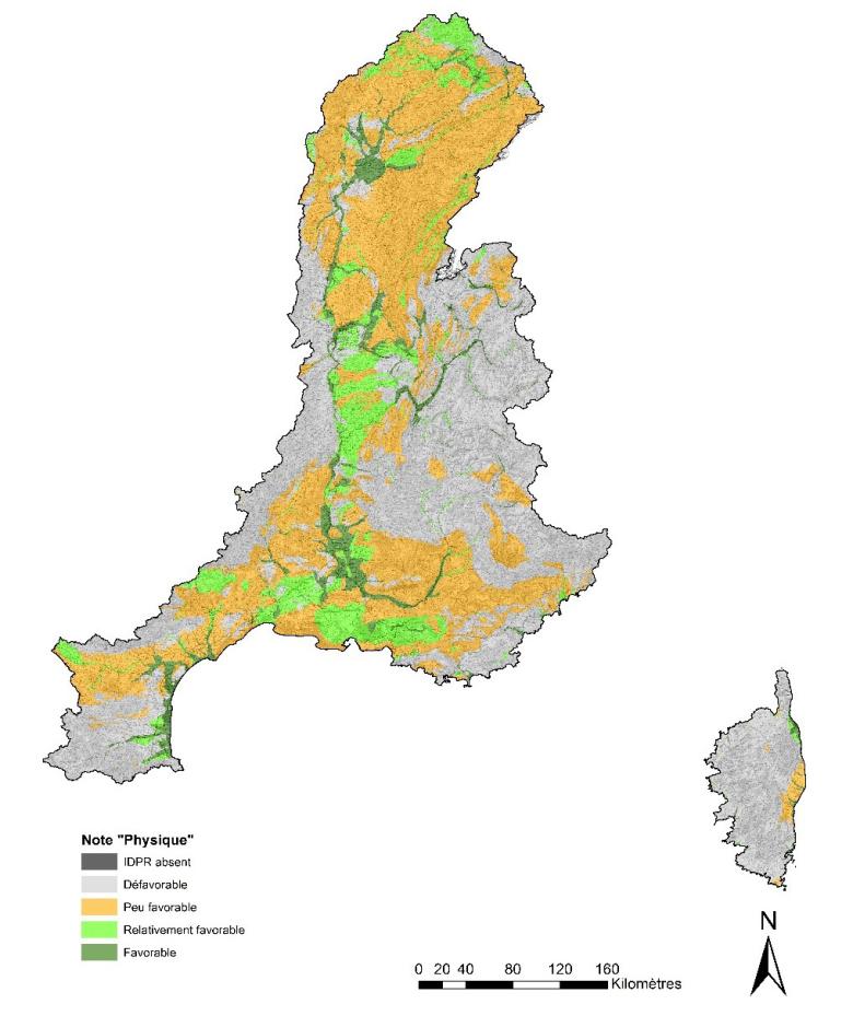
Mapping of the feasibility of indirect artificial recharge based on physical criteria of the land and subsurface, at the RMC basin scale.
© BRGM
Groundwater is an essential resource for the economy of many regions in France. However, due to the large needs to be met for the various categories of use (in particular drinking water supply and agricultural irrigation in summer), there is a structural imbalance for some groundwater masses.
The classic response of managers is to define a volume that can be abstracted, then to cap abstractions and look for alternative resources (hill reservoirs, inter-basin transfers). A complementary solution, as yet little explored in France, consists in artificially increasing the recharge of these water masses. Widely implemented in other countries, particularly in Australia, Israel and Spain, artificial recharge (AR) has advantages that are technical (flexibility), economic (lower investment cost) and environmental (lower energy consumption); consequently, it is worth exploring its potential for the Rhone-Mediterranean and Corsica basin.
The Programme of Measures of the Rhone-Mediterranean SDAGE for the period from 2016 to 2021 provides, among the localised measures related to its fundamental guideline no. 7 aiming at “achieving quantitative balance by improving the sharing of water resources and anticipating the future”, the possibility of setting up artificial groundwater recharge systems.
It is within this framework that BRGM and the RMC Water Agency have launched the research project entitled “Study of the Feasibility of Artificial Recharge in the Rhone Mediterranean and Corsica basin” as part of the R&D agreement between the two establishments.
Project objectives and phasing
The aim of the project is to be able to stimulate reflection in areas suffering from a quantitative deficit, where implementation of an artificial recharge (AR) solution could prove to be interesting, or complementary to more traditional solutions. The project is divided into two phases:
- Phase 1 consisted in highlighting the interest of artificial recharge based on selected experiments in France and abroad and in mapping areas that are potentially favourable, from a purely technical point of view, on the scale of the RMC basin. This phase was written up in an interim report (Caballero et al. 2018; BRGM/RP-67534-FR);
- Phase 2 consists in exploring the technical and economic feasibility of a system for artificial recharging of several test areas, working on a more local scale, in order to draw conclusions and make recommendations that can be applied everywhere. This phase was written up in an interim report (Moiroux et al. 2019; BRGM/RP-68551-FR).
During phase 1, four AR feasibility maps (physical criteria and land-use constraints for indirect AR, physical criteria and land-use constraints for direct AR) were obtained by multi-criteria spatial analysis at the basin scale. In terms of technical feasibility, the hydrogeological and physical geographical criteria were based on the French national hydrogeological reference system (BDLISA - Database of Aquifer System Limits). This made it possible to take into account the characteristics of the aquifers (free/captive, type of porosity, type of fracturing and permeability, lithology, etc.), which may or may not be favourable for an artificial recharge system. The potentially infiltrating nature of geological formations was determined using the Network Development and Persistence Index (IDPR in French). The thickness of the unsaturated zone was also taken into account to incorporate the capacity of the aquifers to absorb infiltrated water. These parameters, which are known and have been mapped on the scale of the Rhone Mediterranean and Corsica basin, made it possible to produce maps of the potential for artificial recharge (direct and indirect) of aquifers on the scale of the basin.
During Phase 2, four test territories were selected with local managers and the AERMC. They are considered to be favourable for artificial recharge and in the light of current challenges, site managers are looking at new ways of managing the groundwater resource to alleviate water quantity and/or quality problems. The four groundwater masses selected are as follows:
- the water table of the Bièvre-Liers-Valloire basin,
- the water tables of the Vistrenque and the Costières,
- the water table of the Astian Sands of Valras-Agde,
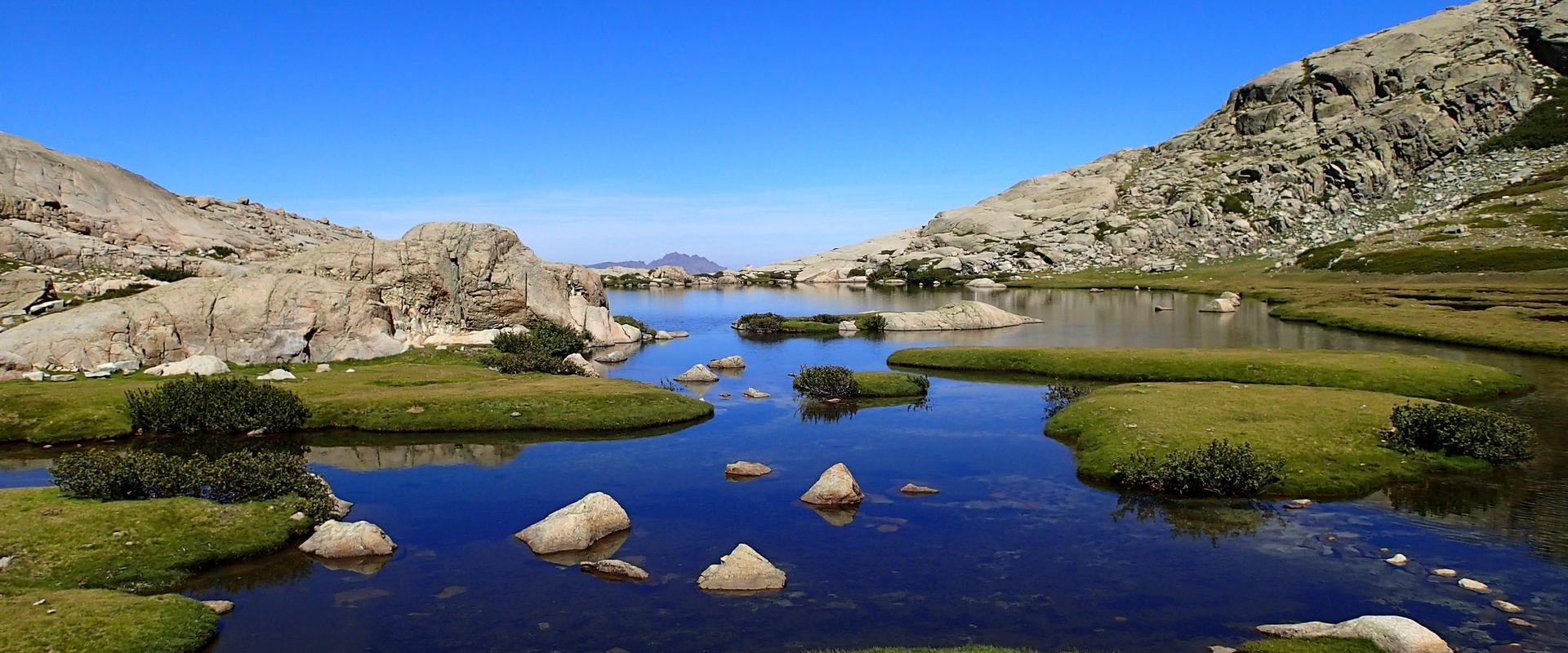
- the alluvial water tables of Figarella (Upper Corsica).

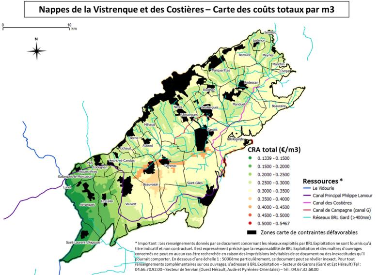
Map of total indirect artificial recharge unit costs (unit cost of AR, expressed in €/m3 of volume of water recharged) for the site of the Vistrenque and Costières aquifers.
© BRGM
After reviewing current knowledge of the various hydrogeological entities selected, the potential for artificial recharge on the scale of each test area (aquifers or groundwater bodies) chosen in the Basin was assessed in order to map the technical feasibility of indirect recharging. Land use constraints were also taken into account by integrating the Corine Land Cover data. The available surface water, its characteristics in terms of quantity and quality, its availability and the projected annual volume of recharge were defined before sizing the recharge systems in terms of surface area and water transfer accordingly.
A distributed cost function was used to calculate and map the unit cost of infiltration at each point of the test areas (see an example in the Figure below). It takes into account the operational and investment costs for the various components of an indirect recharge system: water intake, transfer, pre-treatment, infiltration basin and related costs. The construction of this function revealed the lack of available operational cost data and therefore required a number of cost assumptions.
The pooling of the various cartographic documents produced made it possible to identify the most favourable sites for the installation of infiltration basins in the four test areas studied, while also giving some idea of the order of magnitude of the costs for constructing the facilities.
A seminar to close the project was held in Lyon on 29/01/2019, during which the advantages, disadvantages, obstacles and solutions related to AR were discussed by managers, scientists, stakeholders in the field and engineers.
A methodological guide containing recommendations for the installation of an indirect artificial recharge site is currently being drafted.


