The need
The objective was to provide a decision-support tool to characterise the local exploitability of the main aquifers for a geothermal installation of the water/water heat pump type, and thus to provide technical support for the greatest number (local authorities, professional users or private individuals), enabling them to make well-informed energy choices in this type of situation.
The results
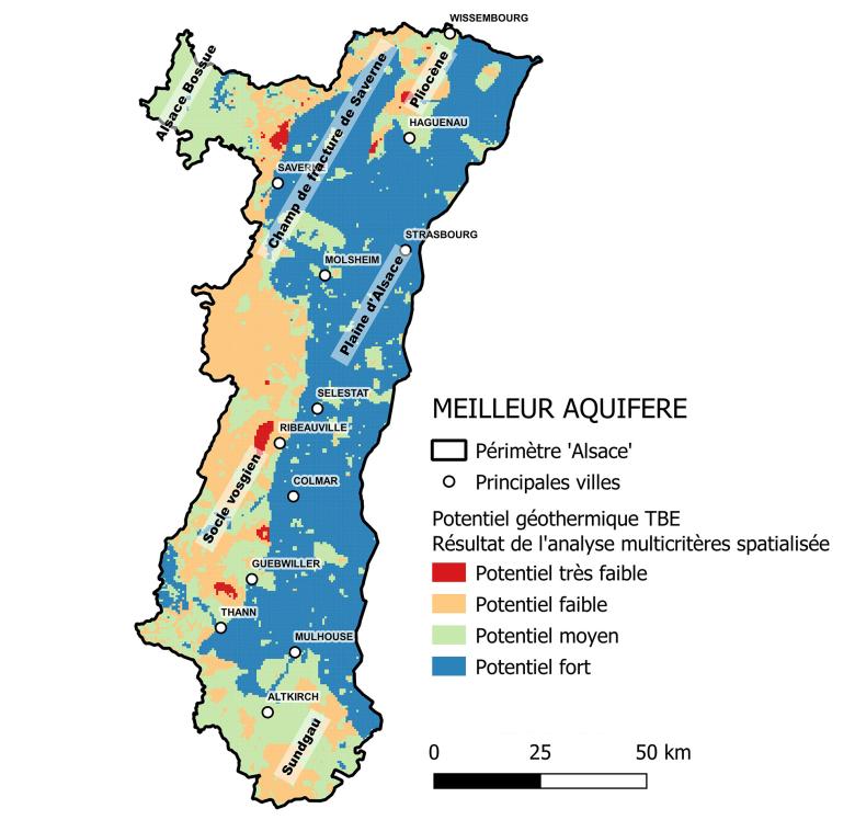
The survey area was divided into seven layers with a grid of 500m x 500m cells. For each cell, the geothermal potential of the aquifer was measured and ranked from strong (blue for favourable) to very weak (red for unfavourable). This assessment was carried out in compliance with national methodology, based on criteria previously defined and analysed for each aquifer under consideration: depth of access, productivity (flow rates) and temperature.
The final results show that the potential geothermal aquifer resources, expressed as a percentage of aquifer coverage in the Alsace area, is 46% favourable (all aquifers together) and 91% favourable in Alsace. Further, any exploitation must comply with applicable regulations (on water, relating to minimum-impact geothermal projects, etc.).
Using the results
The results of the project are available on the public website Geothermies. In particular, the atlas of geothermal potential can be accessed in the maps section of the website. This decision-support tool is intended for use by project managers before making their final decisions on energy choices Nevertheless, the information in the atlas is not intended to replace the feasibility study, which must be carried out for each plot by competent engineering consultancies.

Following the merger of the Regions in 2016, we needed a single atlas, a quantitative approach to near-surface geothermal aquifer resources, since this was missing in Alsace. Today, through our close collaboration with BRGM teams, the entire Grand Est Region has access to the same information. This atlas is a fast, easily accessible tool providing precise data on geothermal potential, in terms of both quantity and quality.


