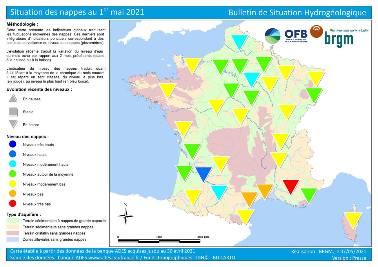
Map of water table levels in France on 1 May 2021.
© BRGM
Hydrogeological situation on 1 May 2021
In April 2021, there was a downward trend for all the aquifers. This was mainly due to the dry weather of the last few weeks but is usual at this time of year. Any rain that manages to filter into the soil is absorbed by vegetation and rarely reaches the water table.
The situation in April was satisfactory, with levels close to or above the monthly averages in the chalk and tertiary formations of the Paris Basin and Artois-Picardy as well as in the alluvial and Plio-quaternary aquifers of the Aquitaine Basin. The situation was less favourable in the rest of the country, with moderately low to very low levels. The benefit of the winter surplus recharge of the water tables has been lessened by the rainfall deficits of recent weeks.
Hydrological Status Report
The national hydrological status report consists of a set of maps with corresponding comments that show the monthly evolution of water resources. It describes the quantitative situation of aquatic environments (effective rainfall, river discharge, groundwater table levels, reservoir-dam filling status) and provides summary information on Prefectoral Orders issued to limit water use during the low-water period.

Seasonal forecasts of the water table situation for May to July 2021
During spring and summer, water seeping into the soil is usually taken up by vegetation. Summer storms favour runoff and generally do not allow for effective infiltration of water. In addition, the seasonal forecasts of Météo-France announce "drier than normal conditions" for the next quarter. Depletion of all of France’s water tables is thus likely to continue until the vegetation becomes dormant, i.e., until October through to the end of November, and/or the occurrence of abundant rainfall episodes.
Rainfall is not expected to recharge the inertial aquifers (in chalk, tertiary formations and volcanic formations), except in the case of very exceptional rainfall events. In the reactive aquifers (alluvial deposits, Jurassic and Cretaceous limestone, Triassic sandstone and basement), trends will depend on local rainfall totals, evapotranspiration and water demand. Significant rainfall events may cause momentary recharges, allowing levels to be sustained or even, very occasionally, to rise.
Risk of drought in the summer of 2021

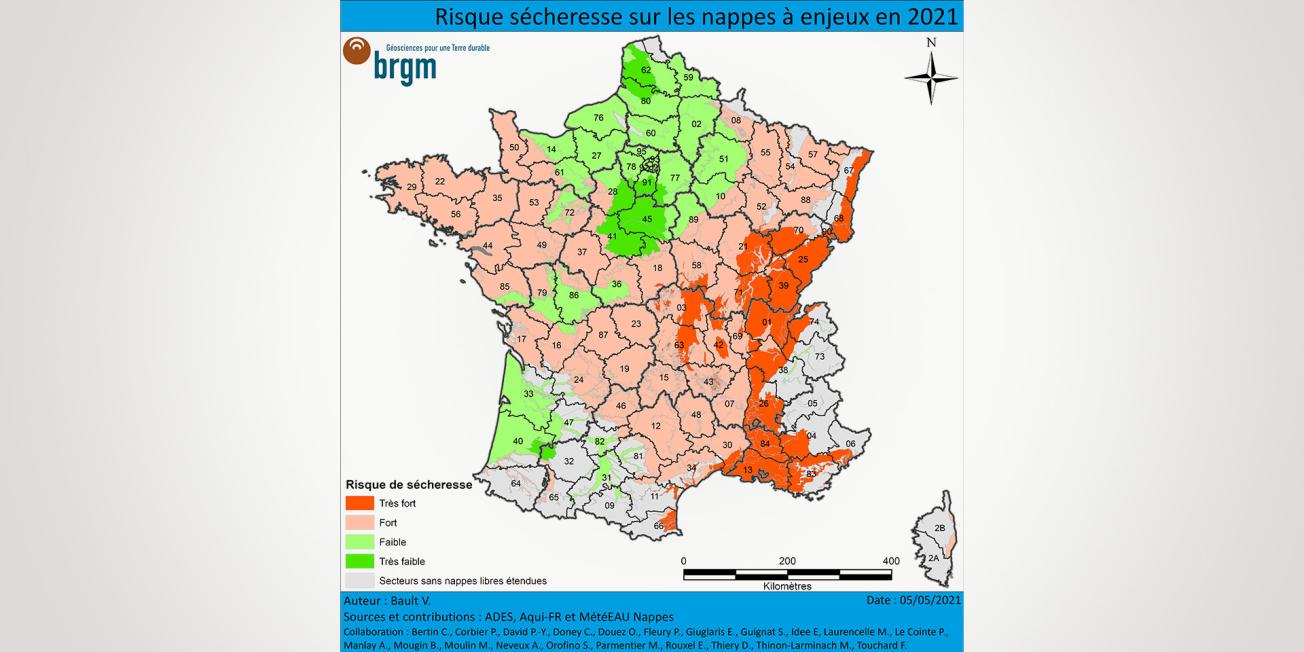
Risk of drought on strategically important water tables in 2021.
© BRGM
Only the central Paris Basin and Aquitaine Basin aquifers are not at risk of drought during the summer of 2021:
- In the Paris Basin, the chalk, limestone and tertiary sand aquifers should remain close to normal levels over the next few weeks. These water tables are not very sensitive to summer drought, due to their high inertia. The forecasts also indicate that levels should remain satisfactory in the Jurassic limestone aquifers of the Boulonnais, Bessin, Brenne and Poitou and in the Carboniferous limestone aquifers of the Avesnois.
- In the central Aquitaine Basin, the benefits of the abundant recharges in the winters of 2019-2020 and 2020-2021 should continue during the summer on the alluvial aquifers of the Garonne and its tributaries, the Plio-Quaternary formations and the Oligocene limestones.
The risk of hydrogeological drought is considered to be high over a large part of France. The rainfall deficits at the end of winter and beginning of spring had a strong impact on the reactive aquifers and the situation is likely to deteriorate further if the meteorological drought continues. However, in these aquifers, the rainfall could lead to an additional recharge episode, allowing the state of the groundwater to improve locally.
In more detail, the risk of strong drought concerns the Armorican Massif and Massif Central basement water tables, the volcanic water tables of the Massif Central, the Triassic sandstone water tables of the Vosges, the Jurassic and Cretaceous limestone water tables of the Paris Basin (Lorraine, Côtes de Bars and Berry), of the Mediterranean coast (Grands Causses and Cévennes) and the Aquitaine Basin (Charentes, Périgord and Causses du Quercy), the Albian sands of Champagne, the chalk formation of Touraine, the Cenomanian sands aquifer of Maine and Perche, the alluvial aquifers of the Adour, the upstream Rhône and Corsica.
In eastern France, the forecast is pessimistic, with a very high risk of drought:
- The water tables of Alsace, Bourgogne-Franche-Comté and Auvergne-Rhône-Alpes have experienced several successive winters with deficient recharge. The water levels of the tertiary formations of the Limagne, the Alsace plain, of the Sundgau region and the Rhône-Saône corridor were already unsatisfactory in April, from low to very low. The levels of these aquifers are expected to deteriorate slowly over the next few months. These water tables could then no longer play their role in mitigating low water levels for the upstream Loire, the Rhône and its tributaries.
- On the Mediterranean coast, the alluvial, tertiary and karstic limestone aquifers of Roussillon, Languedoc, Provence and the Côte d’Azur benefited only from low winter recharge or none at all. It should be noted that any periods of torrential rainfall typical of the Cévennes (épisodes cévenols) will not enable effective recharge of the water tables, due to the violence of the rainfall and the runoff induced. The state of these reactive aquifers will most likely continue to deteriorate, and the situation could become difficult in some areas.
Finally, given the lack of sufficient rainfall and with high temperatures intensifying the dryness of the soils, the demand for water could be significant. Irrigation campaigns and abstractions for leisure activities could increase the pressure on the environment and influence the status of the aquifers. Some heavily used basins could then find themselves under local pressure, even water tables with a low drought risk.
Details as of 18 May 2021
On 18 May, aquifer levels were mostly dropping. The May rains had a local impact on very wet areas, and only on highly reactive water tables (e.g., Massif Central basement, Jurassic and Cretaceous limestone in Provence). For the time being, the rains have moistened the soil and the vegetation has benefited. We will have to wait several more days to find out whether the water has managed to infiltrate deeply and thus observe a stabilisation or even a rise in the water tables.
Given the forecasts announced by Météo-France (warmer and drier than normal for the next three months), the forecasts made for the water tables remain valid. However, this rainfall will make it possible to postpone the irrigation campaigns and thus alleviate the pressure exerted on water resources by agricultural abstractions for the coming weeks.


The drought risk map is based on the initial state of the aquifers after the 2020-2021 winter recharge period (aquifer status reports on 1 April and 1 May 2021), and on the forecasts available until September 2021 carried out within the framework of the Aqui-FR project and from the MétéEAU Nappes models, as well as on the expertise of BRGM hydrogeologists.