What is the risk of drought for aquifers in mainland France for 2022?
Drought risk is defined as the possibility of their reaching, by August-September 2022:
- low to very low levels, which occurs only rarely;
- levels below the alert thresholds defined by prefectural decrees based on representative piezometers.
The forecasts for the aquifers are rather pessimistic.
In order to protect our water resources, it is essential to follow the measures prescribed by the government to save this vital resource. These measures ensure that water levels in the aquifers will be sufficient to supply drinking water to the population and to regulate the flow of rivers.
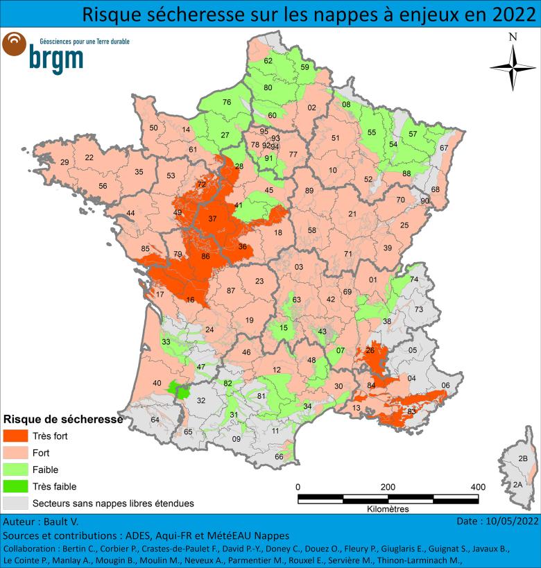
Areas at “very high” risk
In dark red on the map
The “very high” risk of drought has indeed been confirmed in the South-East and concerns the karst limestone water tables of Provence, the alluvial aquifers and the tertiary formations of the Côte d'Azur. The risk also affects the Centre-West, including the Jurassic limestone aquifers of Charentes, Brenne and Poitou, the Cenomanian sands aquifer of Perche and Maine and the Seno-Turonian chalk aquifer of Touraine.
In these areas, groundwater restrictions have already been put in place and the situation is unlikely to improve over the coming weeks.
Areas at “high” risk
In light red on the map
The “high risk” areas have aquifers that are already below normal levels. Their situation could deteriorate rapidly, either due to the lack of sufficient rainfall or to intensive pumping.
Areas at “very low” to “low” risk
Dark green or light green on the map
Finally, the levels of the aquifers identified as “very low” to “low” risk should remain satisfactory throughout the summer. These are inertial aquifers that are not very sensitive to the current year's drought, or reactive aquifers that have benefited from satisfactory recharge.
However, tensions could arise locally, in the event of heavy abstraction of groundwater.

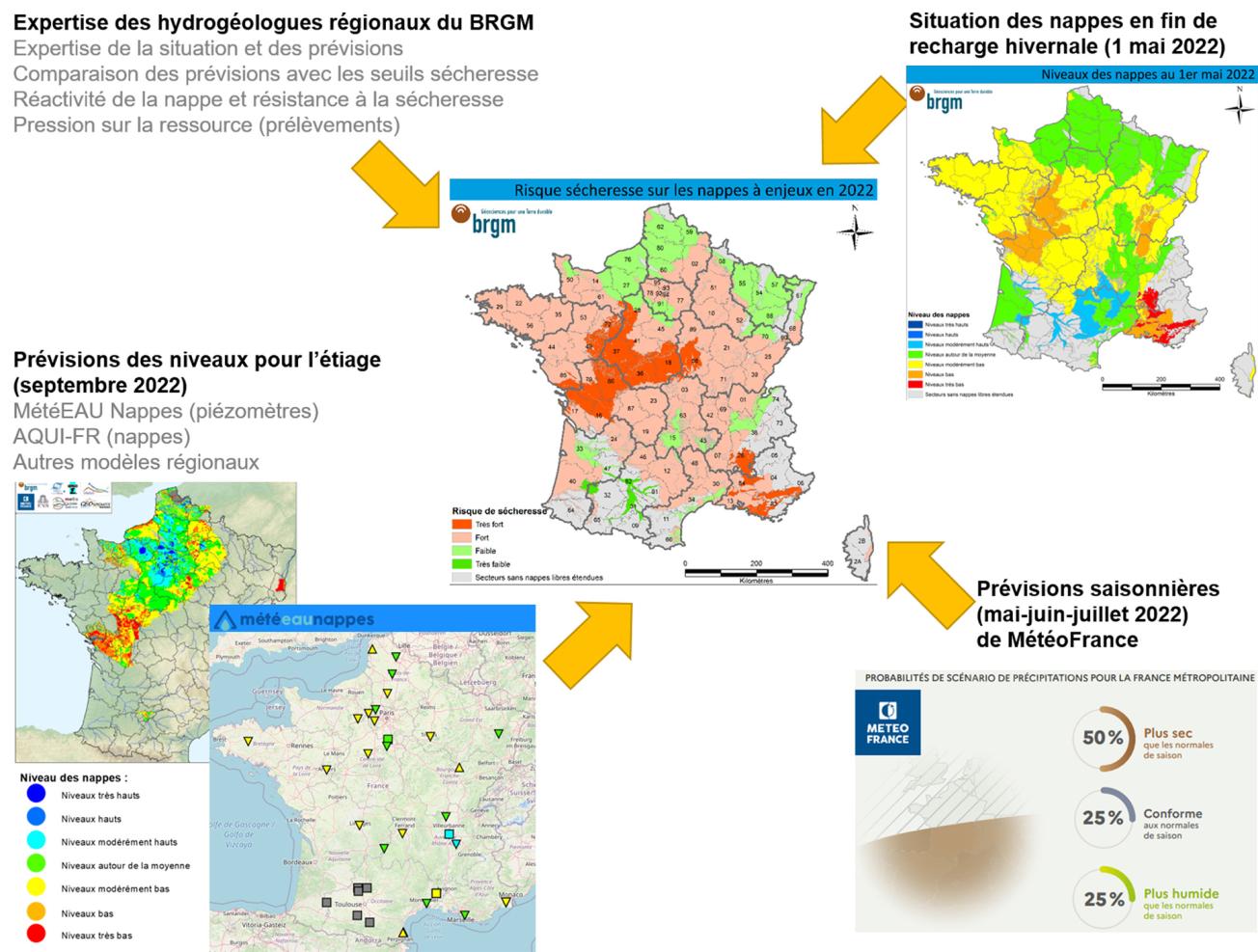
Details of the methodology used to develop the drought risk map.
© BRGM
How is the drought map made?
The drought risk map is based on the initial state of the aquifers after the 2021-2022 winter recharge period, seasonal forecasts from Météo-France, seasonal forecasts from hydrogeological models and the expertise of BRGM regional hydrogeologists.
From spring through summer, rising temperatures, the regrowth of vegetation and thus increased evapo-transpiration usually limit the infiltration of rainfall into groundwater. Between May and October, barring exceptional rainfall events, depletion usually continues and levels continue to fall until the autumn. The evolution of the groundwater situation in the coming months of 2022 will therefore depend on whether effective rainfall manages to infiltrate deep into the ground, on water abstractions and on the resistance of the aquifers to drought.
As for the inertial aquifers, rainfall is not expected to recharge them unless it is exceptionally abundant. The situation in inertial aquifers is expected to deteriorate slowly in the next few months, or more rapidly where there is a strong demand for water.
For reactive aquifers, if rainfall is insufficient, they will probably continue to be depleted, and the situation will thus deteriorate further. Significant rainfall events could nevertheless cause momentary recharges, allowing levels to be sustained temporarily or even, very occasionally, to rise.
The seasonal forecasts of Météo-France indicate a warmer than normal scenario for the whole of France and drier than normal for the southern half.
Consequently, the drought risk map has been drawn up on a pessimistic assumption, considering that the situation of the water tables will probably continue to deteriorate during the coming months. However, it is still possible that oceanic weather fronts crossing France might generate significant recharge episodes. The start of irrigation campaigns could also influence the state of the aquifers.


