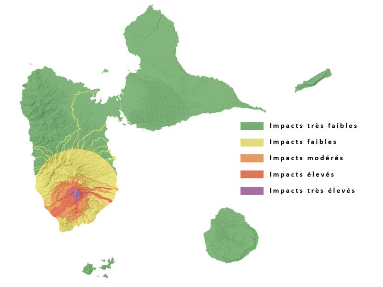
Integrated mapping of volcanic hazards in Guadeloupe to present, on a single map, the potential impact of all volcanic hazards associated with the Guadeloupe Soufrière volcano.
© BRGM - IPGP
The need
For more than thirty years and since the first study conducted by BRGM on the volcanic hazard in Guadeloupe, significant progress has been made in understanding past eruptions of the Guadeloupe Soufrière volcano as well as in characterising and mapping the various related volcanic hazards.
These recent developments had to be integrated into the geological and phenomenological knowledge of the Grande Découverte - Soufrière complex to provide an updated synthesis.
Consequently, as part of the revision of the Natural Risk Prevention Plans (PPRN), the Guadeloupe Department of the Environment, Planning and Housing (DEAL) called on BRGM and the Paris Institute of Earth Physics (IPGP) to draw up a summary note on the volcanic hazard on the scale of the Guadeloupe region and to produce an informative map of the volcanic risks.
The study has several objectives, in particular communicating with the authorities and informing the widest possible public about volcanic hazards and risks in Guadeloupe by providing them with reliable scientific information that has been updated and validated by IPGP and BRGM, both of which are authoritative organisations.
The results
A 15-page summary note on the volcanic hazard for the whole Guadeloupe region was drawn up by BRGM, in collaboration with IPGP.
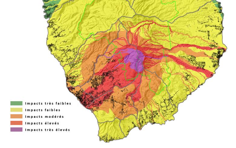
The wide diversity of volcanic hazards, both in relation to the nature of the phenomena and their variability (in terms of intensity, recurrence, spatial extent and impact), makes the analysis and zoning of volcanic hazards for the Guadeloupe Soufrière volcano a complex task. An integrated mapping of volcanic hazards in Guadeloupe has been carried out in order to present, on a single map, in a coherent and homogeneous way, the potential impact of all the various volcanic hazards associated with the Guadeloupe Soufrière. The integrated zoning of the volcanic hazards of Guadeloupe Soufrière is based on mapping the correlation between the eruptive frequency and the eruptive intensity for the entire region. This new map is the result of the latest research work on the Guadeloupe Soufrière (Legendre et al., 2015 - BRGM/RP-65379-EN) and is an update of the map by Komorowski et al., (2005), published in the Guadeloupe DDRM [Departmental File for Major Risks] (2014).

Integrated mapping of volcanic hazards for Sud Basse-Terre (Guadeloupe). The green dotted line shows the limits of the Guadeloupe National Park and in black the built-up area without specific details (© IGN - BD ORTHO).
© BRGM - IPGP
To make it easier to interpret the integrated hazard map, the hazard class was assigned a colour code and a general recommendation level. This classification is as follows:
- Very low impact (green): no recommendation for the normal and permanent use of these areas;
- Low impact (yellow): no specific recommendations, but some vigilance is necessary, especially if there are exposed elements of great or paramount importance in these areas;
- Moderate impact (orange): normal and permanent use of these areas is possible, however specific precautions are recommended, depending on the expected phenomena;
- High impact (red): Normal and permanent use of these areas requires that significant precautions be taken;
- Very high impact (purple): permanent human use should be avoided.
Using the results
The integrated mapping of volcanic hazards in Guadeloupe as well as the summary note on volcanic hazards for the entire Guadeloupe region have been directly integrated into the presentation report of the Plan de Prévention des Risques Naturels prévisibles [Prevention plan for predictable natural hazards] (PPRN) currently being updated in Guadeloupe, and serve as a scientific basis for informing the general public about volcanic hazards.
The partners
- L’Institut de Physique du Globe de Paris (IPGP)
- DEAL Guadeloupe [Guadeloupe Department of the Environment, Planning and Housing]


