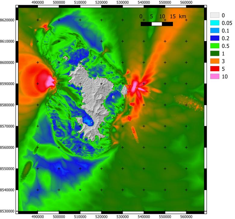
Map of maximum water level rise for all the tsunami simulations considered, caused by gravity-related instability.
© BRGM - I. Thinon
This is the largest nascent volcano observed since 1783. On 10 May 2018, the island of Mayotte in the Indian Ocean suddenly experienced a spectacular telluric phenomenon. For months the island was struck by intense seismic activity. In the summer, shifting and sinking were recorded on the island itself. In order to better understand the phenomenon both on land and at sea, BRGM, CNRS, ENS, IFREMER, IGN and IPGP started working together on an observation campaign to monitor the seabed and water column. This led to the discovery of a new volcano in May 2019. The eruption, still ongoing in 2021, was found to be of the effusive type, and it is causing lava flows and seismic activity that are being continuously mapped. REVOSIMA, the volcanological and seismological monitoring network of Mayotte, is overseeing the monitoring of the phenomenon.
The volcano is located 50 kilometres off the coast of Mayotte at a depth of approximately 3,500 metres, and the huge 800 metre-tall underwater edifice has a diameter of four kilometres. The island itself, which covers only 376 square kilometres, has shifted eastwards by 25 centimetres and sunk by 19 centimetres because of the remarkable draining of a deep magma chamber (about 6.5 cubic kilometres of lava have been discharged). The volcano, which has not yet been officially named, but has been dubbed The Imaginary Monster (Bagug) and The King of the Sea (Mfaloumle Wa Bahari) by Mayotte residents, could pose a threat to the island.
The General Directorate for Risk Prevention of the Ministry for Ecological Transition commissioned BRGM to undertake a study to estimate the potential impacts of tsunamis on the island.
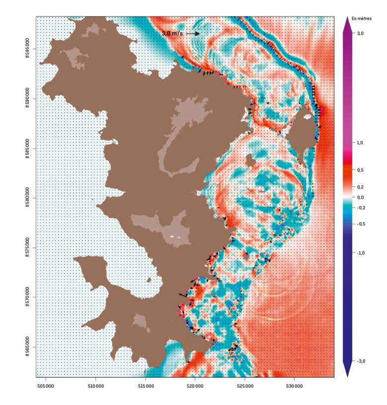
Modelling of tsunami propagation in Mayotte: the map colours show the extent of the water level rise and the black arrows represent water speed at certain shallow points.
© BRGM
Improving the prediction of tsunami hazards
The aim was to use numerical modelling to carry out predictive mapping of coastal flooding in the event of a tsunami occurring, to better estimate the associated hazard. The project has been completed; it was part of the steps taken in June 2019 by four ministries in collaboration with the scientific community to monitor volcanic activity and to better characterise and refine its sources, and improve the prediction and mapping of impacts.
The research teams worked together to determine the types of events that can cause tsunamis near Mayotte, identifying three, namely earthquakes, underwater landslides and collapse of the magma chamber and sides of the submarine volcano.
BRGM modelled 60 simulations from the generation and propagation of tsunamis to coastal flooding. The scientists assessed the protection afforded by the reef and mangrove, along with wave magnitudes and arrival times. The simulations with the greatest impacts on the coast of Mayotte were identified, some of which had high uncertainties, due to a lack of knowledge of the geological structures and the magma system. The models produced to estimate the hazard will need to be refined over time.
The final objective of this project was to develop a tsunami decision support tool and to identify research needs for improving the modelling of tsunami impacts, in collaboration with IPGP. The results were also useful for mapping evacuation routes and documenting future spatial planning projects such as the extension of the airport.
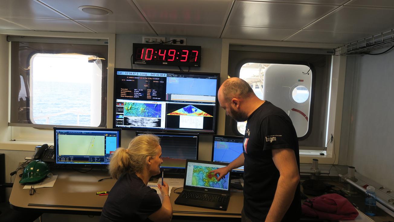
Monitoring of the acoustic acquisition monitoring station during the observation campaign on board the Marion Dufresne, which led to the discovery of the new volcano in May 2019.
© BRGM - I. Thinon
A flagship model of collaborative research
As far as basic research is concerned, this work has also improved interactions between different scientific teams and the status of knowledge in their respective disciplines, bearing in mind the need to forecast events more efficiently in future. This field is very complex indeed, and modelling software and available geological data have been found to be inadequate. There is therefore a need to develop simulation tools that can take into consideration different types of tsunami sources and highly complex field conditions, which influence wave propagation and related flooding.
Furthermore, in the context of civil protection and spatial planning, modelling should not be limited to tsunamis and the flooding they can cause, but should instead include their impacts on buildings and infrastructure. This means that modelling should encompass risks as well.
Teamwork played a major role in this project. The issue requires a truly multidisciplinary approach, involving numerical modelling, computing infrastructure, coastal flooding, hydrodynamic models, landslides, oceanography, volcanology, seismology, communication, geomatics, etc., and can be addressed from different angles, such as from an exploratory, operational or research perspective, and it involves several organisations and ministries.
It is essentially a vast experimental endeavour which the whole scientific community works together on a complex issue, across disciplinary and organisational divides. It serves as a flagship model for open, collaborative research. The Mayotte event also proved to be a useful case study since the work carried out by BRGM and partners can be applied to other geographical areas.
Predictive mapping of tsunami-related coastal flooding in Mayotte
Transcription
BRGM'S SCIENTIFIC ADVANCES IN 2020
PREDICTIVE MAPPING OF TSUNAMI-RELATED COASTAL FLOODING IN MAYOTTE
Welcome, Anne Lemoine. You are a seismologist, a researcher for the Risk Management Department, and one of the specialists working on Mayotte's seismic risks. What is going on in Mayotte? Thank you. Since May 2008, Mayotte has been affected by an exceptional phenomenon on a geological level, starting with earthquakes that were very strong for the area, which isn't used to such strong seismicity. Diverse phenomena were observed, leading to the discovery of a new volcano, the largest active volcano found since 1783. So it's quite a big structure. And it so happens that BRGM was the only institution to have seismic stations on the island and to have a regional office. The time it took for the community to get organized to establish the REVOSIMA, a dedicated monitoring network, BRGM was charged with monitoring these phenomena. A great source of pride. I can imagine, in light of your discoveries, the issue of risk was raised. What can you tell us about that? Yes, the risk factor was an immediate issue. Especially because, as Gilles said, BRGM is sensitive to these issues, to seismic risks, tsunamis, etc. And from the start of this phenomenon, we wondered about its potential impacts. I'll be talking about tsunamis but as a seismologist, I was on the team that monitored the seismic sequences from the start and I'm also on BRGM's tsunami team. On the tsunami team, a colleague, Rodrigo Pedreros, had previously worked on cyclone-induced flood forecasting. So he knew the field and had the necessary data to understand the specificities of properly simulating flooding due to a cyclone. As early as March 2019, preliminary tsunami models were developed. And after the discovery of the new volcano in May 2019, the Ministry of the Environment tasked BRGM with an exploratory research project for the assessment of tsunami impacts through models of three tsunami source types: earthquakes, submarine landslides, and the potential collapse of magma reservoirs. What results did you find through this research? In this exploratory research project, we proposed 60 different scenarios and for each scenario, we built a different tsunami model. This video on the screen depicts the tsunami's propagation near Mayotte. So this is one of the scenarios? Yes, it's a model. A digital model. We imagined a tsunami source, a landslide, to the east of Mayotte. A rather large landslide. We maximized each hypothesis in order to remain conservative. Each colour represents a wave's amplitude. The small arrows represent the water's speed. And what we see on this video is that... the reef is outlined by... the tsunami's propagation, for when it hits the reef at the edge of the lagoon, some of its energy is dissipated. In this kind of video, we can see how a tsunami behaves. We made a model for each of the 60 scenarios and for the scenarios with the biggest impact, we made high-resolution versions so as to estimate, as realistically as possible, the possible flooding it would entail. Mayotte, as a land mass, is a particularly... difficult for creating tsunami models. Elaborating models of tsunamis as we should ideally be doing presents a certain number of technical challenges. On the one hand, this is an active phenomenon with tsunamigenic sources that potentially...
- It's always changing?
- Yes. And some sources are close to the island, so we must not overlook a hypothesis. And technically, in terms of hydrodynamics, we are impeded by the use of certain... rules. Because the sources are very close, we must use certain tools in our models that are highly detailed and specialized. For example, the fact that tsunamigenic sources are rather small compared to the water's thickness above these sources, forces us to use highly-detailed models and to carry out rather complex numerical modelling. In conjunction with this exploratory project, other research projects were conducted, namely in collaboration with our colleagues at the Institut de Physique du Globe de Paris, based on Pablo Poulain's doctoral thesis, which was codirected by Gilles, Rodrigo and colleagues at the Institut de Physique du Globe de Paris. This added another layer of complexity. This layer can be seen on this video. The picture on the top left represents the source, in red. This area of the slope has been destabilized and it is sliding down the slope. On the video, we can see, below the water, the progress of the destabilized sediments as they slide down the slope and at the same time... The fact that the sediments are sliding down the slope will destabilize the water column, generating a tsunami, and the tsunami will spread across the basin. What we see here is that in this hypothesis, which integrates the dynamics, or the landslide flow history, before the landslide has even finished sliding down the slope before the first waves appear. So the phenomenon's dynamics are quite complex and require adapted digital tools or we risk miscalculating the impact... Of course, and having false predictions. This leads to my next question: are these tools fully developed? The tools... To carry out this simulation, there was an initial development. In other words, model codes were coupled. A model that focused on how the landslide rushed down the slope was coupled with a code that focused on how the tsunami spread across this basin, with a reef upon which waves unfurl and the unique specificities of the coastline. To take things further, we need to have a more integrative effect, with codes that are satisfactory for a generation of complex sources and that account for the land's specificities using hydrodynamic codes. As well as this... All the work we've done so far has also allowed us... It's like a case study. It has allowed us to focus our efforts and to understand how we could develop our tools. And BRGM's team members who are working on this type of model also collaborated with INRIA, namely for the development of a code called UHAINA. This code allows us, thanks to one of its interesting characteristics called an "unstructured grid"... This code has many other qualities, but the reason it interests us is because we can use detailed data for areas with particular challenges to make highly-detailed simulations, or to have a higher resolution for a specific source. Because it is very difficult to simulate a source with complex data. So we can hone our models based on the sites we're focusing on. Furthermore, another characteristic of the island of Mayotte that is subjected to such phenomena is that it is unknown from a geological standpoint. But in recent years and months, we've seen a great number of acquisition campaigns, on land and at sea, for a better comprehension of the terrain, the materials, and the active structures. The next step will be to continue developing tools by adapting them to these factors, for better, high-resolution simulations of the effects of a tsunami, of flooding in particular, and to integrate, to the best of our knowledge, geological objects and active structures in order to have realistic sources and models. Another step will be to push these models further, to integrate these models... To integrate damage factors to our models. Damage to infrastructures and buildings. To protect the population, of course. But we're seeing wonderful progress. Looking at these models, we can imagine how they'll look after these factors have been developed for even more precision. The interesting thing about this issue is... The subject we're discussing is very integrative in the sense that it is multidisciplinary. In Mayotte, as Gilles said earlier, this issue has mobilized many specialists and institutes and a whole team of researchers from very different fields.
- It is cross-disciplinary.
- Exactly. Thank you. Thank you both.

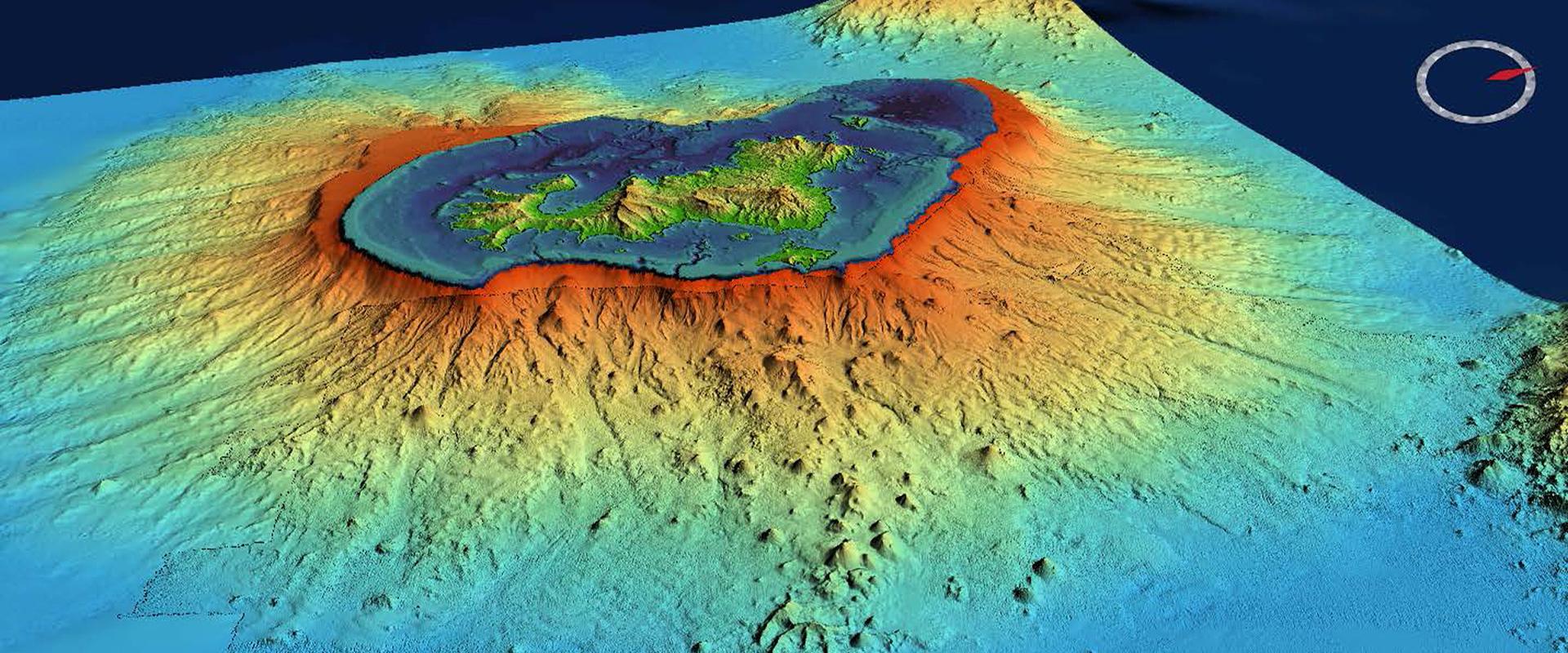

Advances presented in the framework of the scientific programme “Natural hazards and regional resilience”.