Logo of the AD-VITAM project
© Interreg ALCOTRA
BRGM was a partner in the AD-VITAM project, funded by the European ALCOTRA programme and coordinated by the Géoazur laboratory, and which was completed at the end of 2020.
Issues and needs
The project involved assessing the links between rainfall and landslides by studying past events, producing an inventory of ground movement events in the Franco-Italian ALCOTRA area, developing different predictive models, defining the thresholds at which landslides occur and producing dynamic maps of vulnerable areas, which are essential tools for operational management.
The results are mainly intended for the use of local players who are responsible for managing landslide risks and will be immediately applicable across the entire ALCOTRA area. They are also available online to provide information to the general public.
The project's main objective was to effectively integrate rainfall variations – based on past data and future forecasts (climate projections) – in modelled calculations of landslide hazards, an emerging phenomenon that has not been greatly studied to date, unlike rockfall risks (MASSA project). The review of past events was used to produce an inventory and to analyse links between causes and effects in local areas, notably in terms of the impact on communities and their resilience to risks that are specific to mountain environments and common to the Mediterranean periphery.
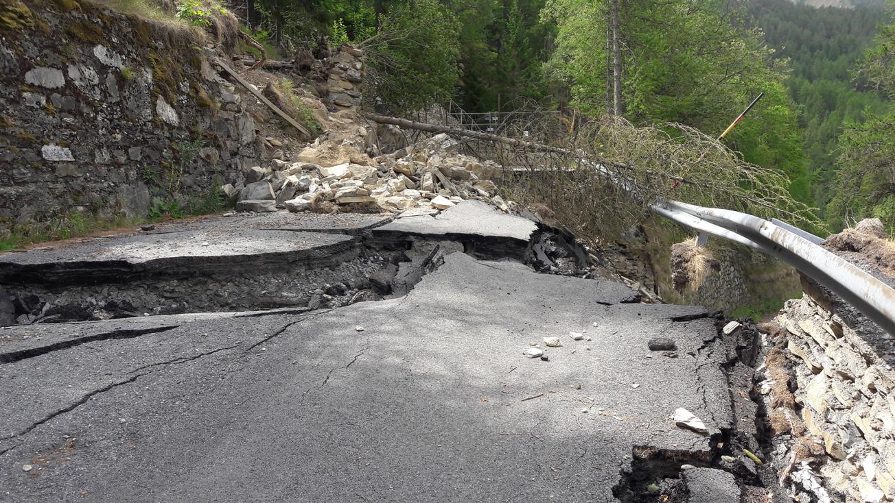
Landslide (Mendatica di Monesi, Liguria, Italy, 2017).
© BRGM
Results and use
Communication campaigns, coordinated by ARPAL
- Information provided to the local population on the following topics: "a resilient area", "understanding in order to plan ahead", "protecting yourselves " and "understanding past events";
- Educating people about the risks;
- Training technicians, by organising several seminars during the project;
- Production of a French-Italian glossary to improve understanding between French and Italian technicians;
- Production of practical guides;
- A seminar to report the results of the project.
Work on the history of past events, coordinated by the Piedmont Region
- Updating the inventory of past ground-movement events across the entire Franco-Italian ALCOTRA area concerned;
- Identification of the areas with sloping terrains vulnerable to surface landslides by drawing up a map detailing the vulnerability of slopes to landslides, sometimes through the use of models;
- Characterisation of episodes of heavy rainfall and related ground movements (rock falls, landslides) through a review of past events, and characterisation of the specific nature of certain commonly-occurring episodes of heavy rainfall linked to ground movements, along with the probable consequences in terms of ground movements caused in areas such as the Alpes-Maritimes region (on the French side) and the Liguria, Piedmont and Aosta Valley regions (on the Italian side);
- A proposal setting out the thresholds at which landslides are triggered at the scale of the Alpes-Maritimes area, based on weather data and past landslide events (drawing on 15 years of data, 2000-2015).
Modelling operations, coordinated by BRGM
- Testing existing models for predicting ground movements (landslides) on the French and Italian sides (ALICE ©BRGM, LAMP ©UNIGE, YASSA ©ARPAL) of previously identified areas, taking into account their topography, the potential impacts, their geological context and past events (high-risk basins, road sections, etc.). The process first took into account a constant water level (piezometric levels synchronous with overall rainfall), then incorporated past episodes of heavy rainfall (for example, the episodes of 2014 which greatly affected the Alpes-Maritimes and Liguria regions), in order to obtain probability maps of the likelihood of landslides, for a certain number of pilot sites;
- Improvement of landslide modelling by integrating spatial rainfall data from weather radars (in this case, the Mont Vial radar in the Alpes-Maritimes managed by Novimet® and the Monte Settepani radar in Italy) into the tools to improve the probability maps by making them "dynamic", and by increasing the accuracy of the models as regards landslide likelihood;
- Work on real-time landslide forecasting (over a period of about 1 to 2 hours between the arrival of a front of heavy rainfall and the beginning of the actual rainfall episode), in order to make the landslide probability maps dynamic by integrating the radar water front data a few hours before its arrival in order to update the landslide likelihood areas, if need be;
- Drawing on the ALICE model developed by BRGM, an analysis can now be performed by setting up a processing chain starting with the radar rainfall measurement (1km² area) at a given date, then integrating the radar rainfall data into the Gardenia hydrogeological model, calculating the groundwater level on the day concerned, selecting the Factor of Safety (FoS) map among all the pre-calculated maps corresponding to the given groundwater level and, finally, producing a probability map corresponding to the groundwater level on the day in question. The aim today is to make this processing chain operational so it can be used by local communities;
- Work on a predictive model (FLAME ©BRGM) that can forecast the speed of landslide movements according to rainfall data, on known landslide sites with records of land movement and piezometric data over several years. Initially planned for use on the sites equipped with GPS instruments during the AD-VITAM project (Vence, Ceriana and Mandatica di Monesi), the analysis using FLAME was finally carried out on the Borgata landslide site in the Piedmont region.
BRGM's role
Brgm's role in the project involved providing its expertise in geology and its tools for analysing risks associated with landslides: analysis of past events, geological data products and pre-analysis of risks. The work carried out by brgm notably involved coordinating the modelling component and supervising the work of several master's internships as well as A phd thesis (drouillas Y., Forthcoming publication).
Brgm's objectives through this project were to pool knowledge on natural hazards (landslides) in order to disseminate the information more broadly and effectively, to adapt and upgrade the risk-prevention tools developed at BRGM (modelling) to integrate factors that can trigger landslides (rainfall), to exchange ideas with our italian partners on scientific modelling techniques and to respond to the needs of those involved in managing risks by raising awareness among elected officials and training them in the use of risk-prevention tools to improve local area management and long-term resilience.
Partners
- French: Géoazur and BRGM
- Italian: ARPAL, The Fondazione Montagna Sicura (Aosta Valley [safe mountain foundation]), Unige University of Genoa, ARPA Liguria, The Piedmont Region, and The Val D'ormea, Argentina and Mendatica Intermunicipal Authority

