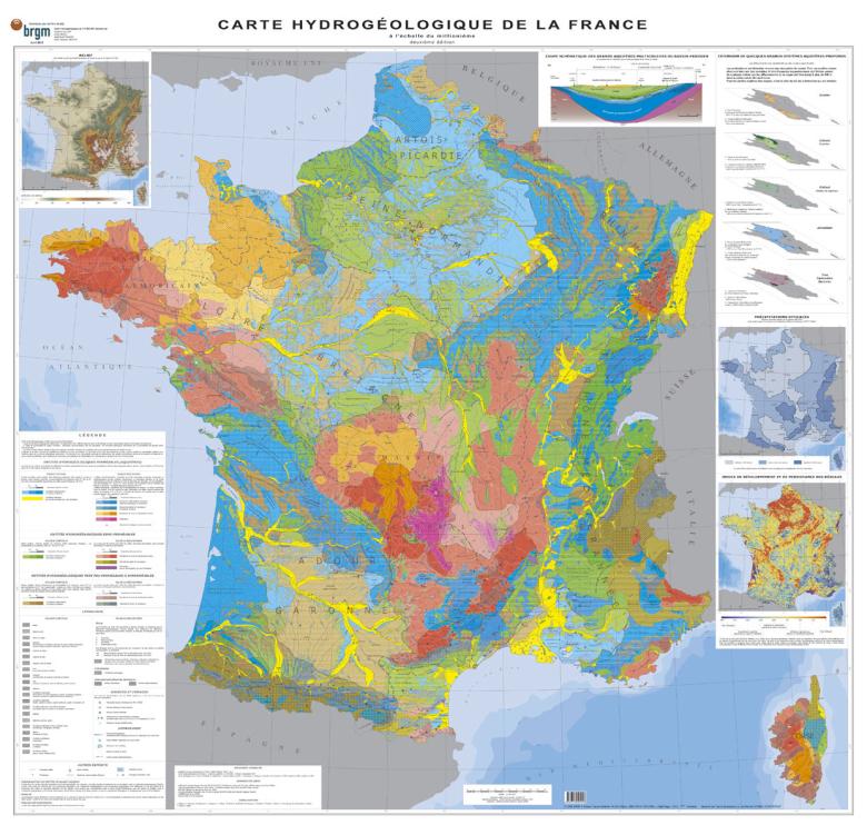
A hydrogeological map can notably be used to locate geological formations with aquifers, which are (or could be) exploited for the drinking water supply, irrigation or industry.
The first hydrogeological map of France was published over forty years ago, in 1978. Consequently, in 2014, BRGM decided to launch the production of a second edition. The new map provides a higher resolution, with a scale of 1:1,000,000 (1 cm = 10 km), whereas the previous map was at 1:1,500,000 (1 cm = 15 km). It is also more accurate, as it draws on the new French hydrogeological reference database, BDLisa, developed from 2006 to 2011 and distributed since 2012. This reference base divides the region into hydrogeological units, defined by their type of geological formation (alluvial, sedimentary, bedrock, volcanic, mountains with intense folding) and characterised by their lithology (sand, limestone, sandstone, etc.), their permeability (i.e. their greater or lesser capacity to supply water) and their porosity.
Aquifers are also characterised by their type of groundwater flow. The flow may be continuous, as in sedimentary basins (Paris Basin, Aquitaine Basin), where the water table flows through the whole geological formation, or discontinuous, as in bedrock formations (Armorican Massif, Massif Central), where the flow occurs through more-or-less-interconnected cracks in the rock. The map is divided into zones according to climate, based on data supplied by Météo-France, and therefore also provides an indication of aquifer recharge, i.e. the proportion of rainfall that replenishes the aquifers.
The map summarises basic information about France's water resources and is aimed at every type of audience, from experts to the general public (and notably for educational purposes in schools).
Colour-grading of zones according to climate
Below are few general notes about the new map. Users will notice that the Paris and Aquitaine basins are shown in predominantly blue and green colours, reflecting permeable (blue) and semi-permeable (green) sedimentary formations. Equally, the bedrock zones stand out clearly in Brittany and the Massif Central. These areas are less productive than those mentioned above, due to their discontinuous underground flows (mainly through cracks). Finally, it should be noted that mountainous areas, such as the Alps, tend to have aquifers with very low permeability. For each colour range, a gradient is used to position the aquifers according to their climate-zone criteria, with darker colours indicating more abundant recharges of aquifers through rainfall.
In the future, this map could be exploited to provide additional data for geographic information systems. Moreover, it could be supplemented by a map of water resources that focuses more on the content (the water) than on the container (aquifers).
What is an aquifer?
Geological formations that contain a significant volume of exploitable groundwater are called aquifers. An aquifer is a container, the groundwater is its content. Aquifers are not, as some might imagine, underground lakes; the water that circulates in an aquifer only occupies cavities in the rock (pores, cracks, fractures). The main criterion for distinguishing between aquifers and non-aquifers is permeability, a parameter that quantifies the capacity of the geological formation to allow water to circulate. Recent sands (dunes), but also sands deposited by ancient Mesozoic and Cenozoic seas, are very porous and permeable. Limestone and sandstone formations are also very permeable. These types of formations can be exploited by drilling wells that can deliver more than 100 m3/h. In some areas (Causses, Quercy, Jura, among others), a significant dissolution of the limestone has resulted in karst formations, some of which contain genuine underground rivers. Many springs, outlets of the karst massifs, are exploited for drinking water supply. The rocks of the bedrock domains (granite and gneiss in particular) are characterised by cracks and more or less interconnected fractures. Abstraction rates are generally of the order of a few m3/h and rarely exceed 20 m3/h. This level of permeability is lower than that of sedimentary rocks.
Among aquifers, a distinction is made between those in which the groundwater is free and those in which it is confined. In the first case, the free surface of the groundwater does not reach the upper level or roof of the aquifer. This roof may be the surface of the ground, in which case it is sometimes referred to as a phreatic aquifer. In the second case, the water table is trapped – captive – under an impermeable roof. It is therefore under pressure. Two or more aquifers may be superimposed, separated by low-permeability layers. This is known as a multi-layer aquifer. There may be slow but significant exchanges between the different aquifer layers.


