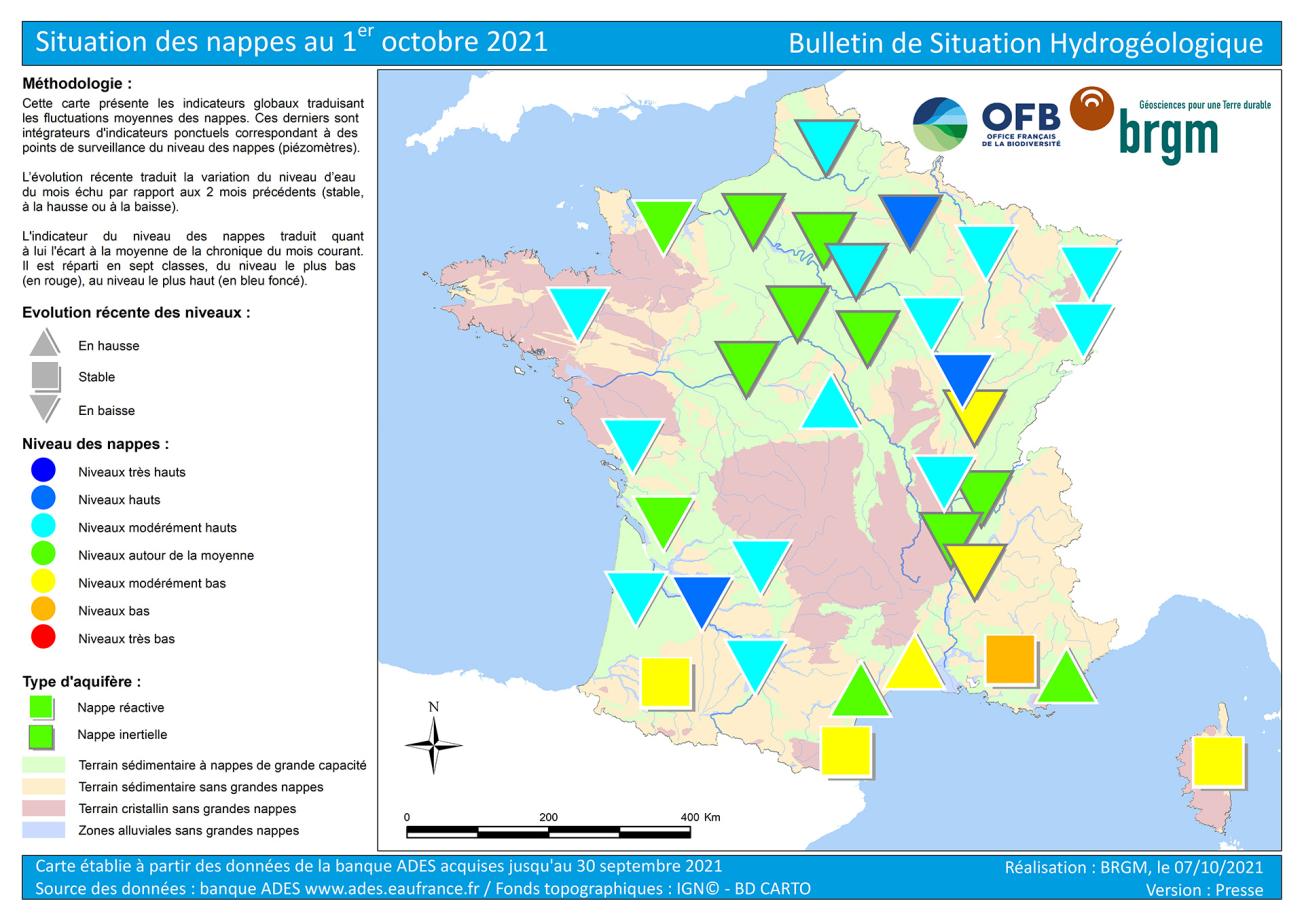
Map of groundwater tables in France on 1 October 2021.
© BRGM
Hydrogeological situation on 1 October 2021
After a very atypical spring and early summer of 2021, with exceptional recharge episodes, depletion had resumed in August. In September, the trends were contrasted according to rainfall and the responsiveness of the water tables. Depletion continued over a large part of the territory, with levels falling. Levels were rising or stable in areas that have benefited from rainfall and that have reactive aquifers: in southern France and in the limestone formations in the Berry region.
The situation in September was generally very satisfactory, with levels comparable to above monthly averages. It remains less satisfactory, with moderately low to low levels in the Adour and Gave de Pau alluvial aquifers, certain deep aquifers in the Rhône-Saône corridor and reactive aquifers along the Mediterranean and Corsica coastlines.
In October, the recharge period could start in areas with reactive aquifers, that benefited from rainfall and the situation should then improve. Inertial aquifers should remain on a downward trend or stabilise, but the situation is not expected to change significantly.
Trends of groundwater table levels
During the autumn and winter of 2020–2021, most of France experienced substantial groundwater recharge, except along the Mediterranean coastline, where the recharge was very low. Between February and April, the lack of effective rainfall resulted in significant and unusual drops in levels. The abundant rainfall between May and July, combined with low evapotranspiration, slowed down the intensity of depletion and even led to exceptional recharging episodes that are atypical for this period. In August, the depletion phase resumed throughout the country.
In September, the depletion continued for a high proportion of the aquifers and, overall, the levels remain on a downward trend. This phenomenon is common in the summer and early autumn. Until the vegetation becomes dormant, the rainfall is rarely effective enough to recharge the aquifers, as the water that does manage to infiltrate the ground is entirely taken up by the vegetation.
However, in the south-western half of the country, the rainfall in September has had an effect on the areas that had the most rainfall and that have reactive aquifers. Thus, the depletion is slowing down even though the monthly aquifer levels are still mostly down in the Aquitaine Basin, the basement of the Massif Armoricain and the Massif Central and the Jurassic limestone formations of the Côte-des-Bar. Levels have stabilised or even risen in the Berry limestone aquifer and in the aquifers on the southern fringe of France: the Adour and Gave de Pau alluvial aquifers, and the aquifers along the Mediterranean and Corsican coastlines.
Situation in relation to September averages
In September, the situation of the aquifers changed little compared to the previous month. It remains particularly satisfactory over a large part of France, with levels comparable to normal to high, and more fragile for certain inertial aquifers in the Rhône-Saône corridor and in the reactive aquifers in the south of France.
In the northern half and western France, levels are around the monthly average to high in the Artois-Picardy, Rhine-Meuse, Seine-Normandy, Loire-Bretagne and Garonne basins. This favourable situation is due in particular to the significant recharge last winter and to the recharge episodes recorded in May-June which affected the reactive and inertial aquifers. The situation in September was comparable to the previous month for inertial aquifers and has deteriorated very slightly for some reactive aquifers. The only exception was the situation in the reactive Berry limestone aquifer, which improved during the month following abundant effective rainfall.
In the Rhône basin, the water levels in the reactive alluvial aquifers of the Rhône, the Saône and their tributaries are very satisfactory, from moderately high to high. The significant rainfall between May and July helped to recharge these surface waters and considerably improve their condition. However, in the same sector, the inertial aquifers of the Plio-Quaternary and Miocene formations show less favourable levels, from moderately low to comparable to normal. The situation may be more strained locally, with low to very low levels. These water tables are evolving very slowly and the unusual recharges during the summer have not made up for the deficits of previous winters.
In the south, in the Adour region, on the Mediterranean rim and in Corsica, the situation has improved slightly compared to August, due to rainfall, but it remains fragile. Levels are moderately low to comparable to monthly averages. They are locally more heterogeneous, from high to very low levels, depending on local rainfall and the capacity of the groundwater table to resist drought. However, this condition has been common in recent years in these areas at the end of the summer depletion period.
Several aquifers are in a very good condition, with high to very high levels in relation to September levels in previous years:
- The alluvial aquifers of the upper Saône and its tributaries reached very high levels following the high recharges in May, June and July;
- The Champagne chalk aquifer shows high levels, due to a good winter recharge and a very wet July;
- The alluvial aquifers of the downstream Garonne and the Dordogne have high levels due to substantial winter recharge and have been kept high by the rainfall from May to July.
The situation is not as good for some aquifers, with levels below September averages and requiring close monitoring:
- The Pliocene gravel aquifers in Burgundy-Franche-Comté are showing moderately low levels, due to several successive, weak winter recharges that have not been compensated for by the exceptional inflows at the beginning of summer;
- The alluvial aquifers of the Adour and Gave de Pau show moderately low but stable levels, suggesting the beginning of rechargng;
- Some alluvial, complex and karstic aquifers in the Roussillon, Montpellier and Nîmes, Provence and Corsican regions benefited from rainfall in September but still have moderately low to low levels;
- Corsica’s alluvial aquifer levels are moderately low.
Forecasts
Météo-France’s temperature forecasts for October, November and December indicate a scenario that is probably close to normal throughout the country. There is no preferred scenario for precipitation.
The beginning of autumn is generally a pivotal period, between the end of the summer depletion (falling levels) and the beginning of the winter recharge (rising levels). The reversal of trends will depend on infiltrated rainfall, and therefore on rainfall and vegetation dormancy, groundwater abstraction and groundwater inertia.
Following the rainfall in September, rising or stable water levels were observed in reactive aquifers, particularly in the south of France. The rains forecast for October should confirm the reversal of the trends. Recharge could start in October, with rising levels, on those reactive aquifers that get the most rainfall (notably alluvial, karstic limestone and basement aquifers). It could be extended to the whole country in the coming weeks.
For the most inertial aquifers, the October rainfall is not expected to generate significant recharge. The depletion is expected to continue at least until November. Indeed, the reaction time between rainfall and a rise in water level can be several weeks and up to three months.
In October, the situation of the water tables could start to improve in those areas that benefit from rainfall and that have reactive water tables. It should remain relatively similar to that of September for the very inert aquifers.
The aquifer situation should remain satisfactory over a large part of France. The aquifers in south-eastern France as well as the Adour and Gave de Pau should be monitored carefully, particularly in the event of a lack of precipitation and heavy demands on the groundwater.
Hydrological Status Report
The national hydrological status report consists of a set of maps with corresponding comments that show the monthly evolution of water resources. It describes the quantitative situation of aquatic environments (effective rainfall, river discharge, groundwater table levels, reservoir-dam filling status) and provides summary information on Prefectoral Orders issued to limit water use during the low-water period.


