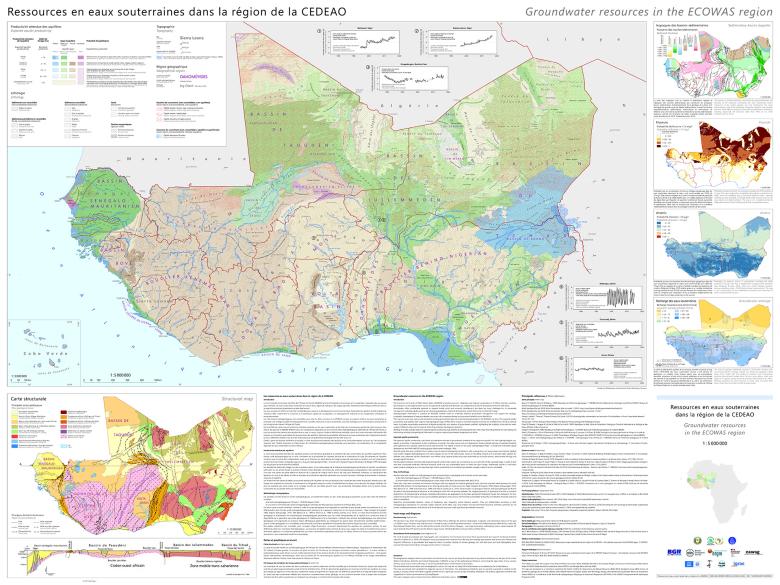
Hydrogeological map of the Economic Community of West African States (ECOWAS) (2022)
© BGR, BGS, BRGM, EAWAG & UNESCO
Under the aegis of UNESCO, the German, British and French geological surveys pooled their knowledge to consolidate and update their respective hydrogeological maps for the region covered by the Economic Community of West African States (ECOWAS).
This map was presented at the World Water Forum in Dakar (Senegal) on 22 March 2022.
An overall picture of the potential of regional aquifers
This collaborative project for the benefit of the African States that make up ECOWAS was made possible thanks to the scientific support of several partners and experts, with aid from the French Ministry of Europe and Foreign Affairs (as regards BRGM's contribution to the project).
This map (at a scale of 1:5000000) provides an overall picture of the potential of regional aquifers. The document includes detailed inset maps, cross sections and graphs that supplement the hydrogeological information.
In addition to its contribution to the hydrogeological map of West Africa, BRGM was also one of the partners involved in the map of Groundwater in fast growing cities in western Africa produced by IGRAC (International Groundwater Resources Assessment Centre) in 2021.
Groundwater has considerable potential to support social and economic development in West Africa
The Economic Community of West African States (ECOWAS) promotes economic integration and regional cooperation in its fifteen member countries.
Groundwater represents a crucial regional source of water for agricultural, industrial and domestic uses. As such, it drives economic prosperity and contributes to human well-being. However, ensuring the sustainable management of these resources involves dealing with many challenges, including rapid population growth and urbanisation, industrial development and climate change.
It is therefore crucial that ECOWAS Member States have access to hydrogeological information to help them establish effective groundwater management policies and build a sustainable strategy for the development of new resources to ensure long-term socio-economic benefits across the entire West African region.
This set of maps consolidates existing groundwater data and draws on all the existing knowledge concerning groundwater resources in each of the ECOWAS countries. Bringing together all the data provided by previous regional hydrogeological maps of West Africa, this map of expected aquifer-productivity levels provides a consistent regional overview that could not be achieved using individual national maps. It provides a quantitative assessment of aquifer productivity, indicating the potential of groundwater resources for water supply at different scales, as well as the physical limits of its development potential.


