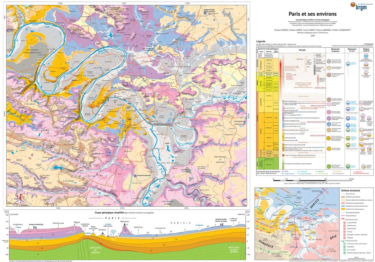
Educational geological map of Paris and its surrounding area (BRGM Éditions, 2022).
© BRGM
The emblematic zinc roofs of Paris, the white tiles of the metro, the iron of the Eiffel Tower, the stones of Notre-Dame and the buildings designed by Haussmann, are just a few elements of a little-known mineral world that has nevertheless left its mark on our capital and its surroundings.
Despite this discreet presence, we rarely make the connection with the subsurface. However, in addition to these famous examples, many minerals are used in our daily lives (health, transport, construction, energy). Although recycling is becoming increasingly important, raw materials are still being extracted in the Paris Basin.
In order to make it easy to visualise where our resources come from, the location of groundwater and sectors that may involve natural hazards, BRGM has made a new geological map for educational purposes.
Some examples of applications of this new educational map
Useful mineral resources
Mineral resources have no borders and are not distributed randomly. They are the result of a long geological history spanning several million years, a time span that is often difficult for most of us to grasp. The quarries in the vicinity of Paris thus afford glimpses of the subsurface, which is difficult to observe in this flat region.
Mineral resources have always been extracted to meet the needs of our societies. This is particularly the case in this digital and energy transition age, in which the dematerialised world and new types of mobility are major consumers of mineral materials. The current demand is thus particularly high.
Gypsum, for example, which is used to make plaster and cement, is classified as a resource of strategic importance to France and Europe. A resource that is all the more crucial in that a very large proportion of it is difficult to reach due to rapid urbanisation. The Montmorency gypsum quarry (Val d'Oise) is one of the largest in France (Société du Grand Paris).
Water, a vital resource, which is often underground
There is more than just rock underground. There is also water!
In France, a person consumes an average of 150 litres of water per day. The daily needs for the Île-de-France population are thus 1.8 million m3, or more than 500 Olympic-sized swimming pools.
Much of the water we consume comes from aquifers. Knowledge of the subsurface therefore plays a major role in characterising this vital resource.
In the Île-de-France region, there are several aquifers at different depths, one above the other, mainly in limestone and sandy formations. These aquifers are seperated by two major clay layers, often marked on the surface by the presence of springs whose water has been captured and conveyed to the heart of the capital.
Interestingly, the respective concentrations of various mineral salts in the water varies according to the nature of the surrounding rocks. The sulphate, carbonate, calcium, magnesium and sodium content is not the same in the north and south of Paris.
Spatial planning and risks
A reliable knowledge of the subsurface is vital when planning underground constructions and networks.
For instance, it is necessary to avoid old quarries and areas where gypsum has dissolved, to beware of rockfalls and sectors where underground aquifers are likely to rise, or to anticipate the the phenomenon of clay shrinkage and swelling which can cause major damage to buildings on the surface. For these reasons, the building of large structures has sometimes involved technical challenges.


