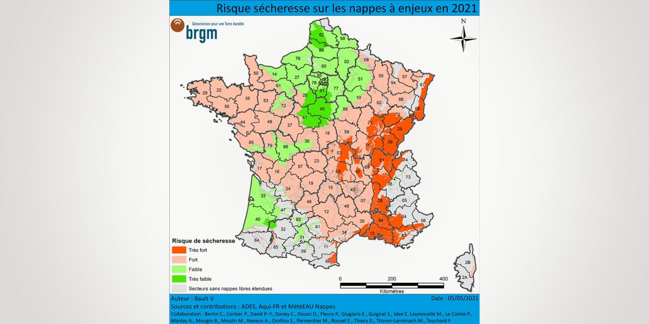
Risk of drought on strategically important water tables in 2021.
© BRGM
At the beginning of May 2021, BRGM produced a summer drought-risk map for aquifers. These forecasts are rather pessimistic, with levels likely to be low for the summer for a large proportion of the aquifers. There is even a very high risk of drought in eastern France - from Alsace to Provence. Only the central Parisian Basin and Artois aquifers, and some aquifers in the Aquitaine Basin, are likely to be spared.
However, there was significant rainfall in May, June and July over a large part of France. The drought risk map was partly based on seasonal forecasts from Météo-France of “hot and dry” weather for May, June and July.
This raises the question of what impact the heavy rainfall will have had on aquifer levels and whether this might require updating the drought risk map and its associated information.
How is the drought risk map produced?
The map was drawn up by BRGM regional hydrogeologists.
Their forecast is based on the initial state of the aquifers after the 2020-2021 winter recharge period, on the seasonal temperature and rainfall forecasts by Météo France, and on the available forecasts of aquifer levels up to September 2021 (generated within the framework of the Aqui-FR project project and produced from the météEAU Nappes models).
What impact has the rain in May, June and July had?
The rainfall in summer does not generally recharge aquifers.
The water that soaks into the ground is usually taken up by vegetation, and summer storms result in more runoff and thus less effective infiltration.
The rainfall of the last few months has had little impact on the aquifers: levels have generally remained low, but the situation improved during May, June and July.
What is the current risk of drought?
The summer drought risk map is still valid today, even if this risk has been reduced in many areas thanks to the rainfall in late spring and early summer.
A very high risk of drought (in dark red on the map) has been confirmed for the aquifers along the Mediterranean coastline and along the Saône and Rhône valleys (couloir Rhodanien). In these areas, groundwater restrictions have already been imposed. Even though it has rained well in the Rhône-Saône corridor and the rivers are high, the aquifers from the Bresse to the Bas-Dauphiné have only slightly recharged.


The drought risk map is based on the initial state of the aquifers after the 2020-2021 winter recharge period (aquifer status reports on 1 April and 1 May 2021), and on the forecasts available until September 2021 carried out within the framework of the Aqui-FR project and from the MétéEAU Nappes models, as well as on the expertise of BRGM hydrogeologists.