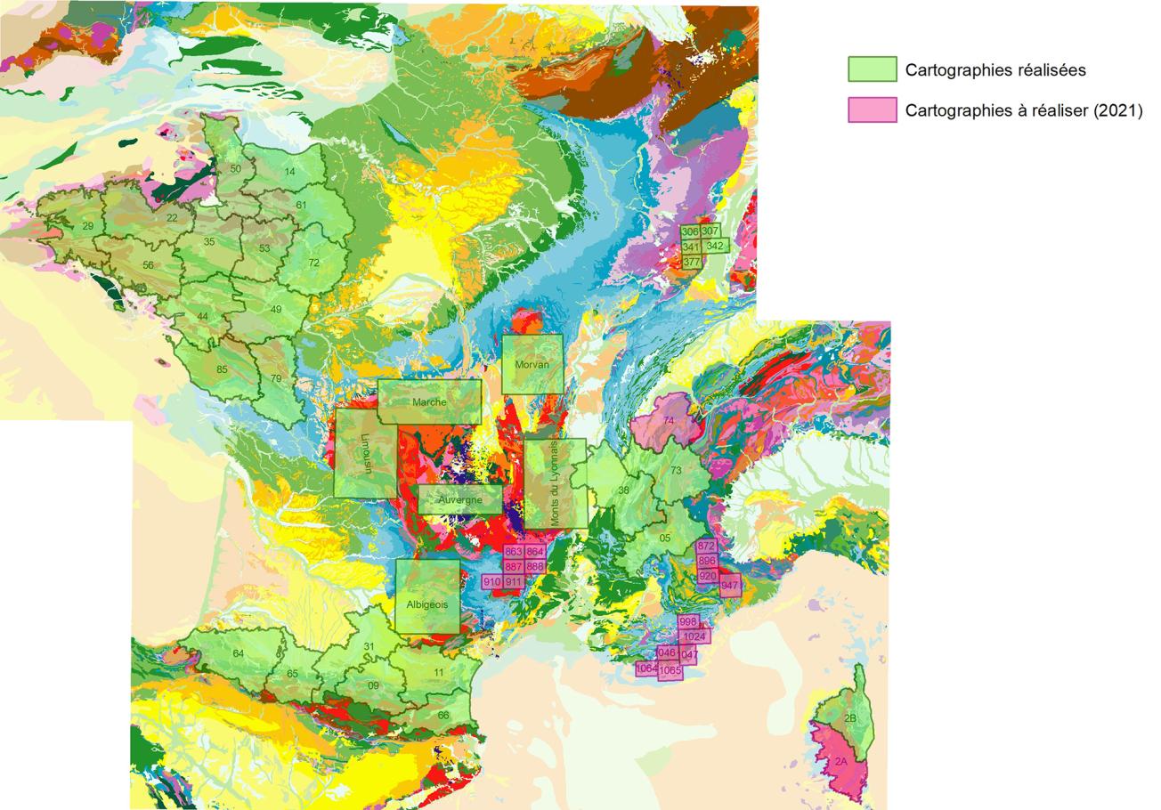
National map of mapped areas and areas being mapped for the likelihood of there being natural asbestos in the environment.
© BRGM
The need
One of the actions undertaken in the 4th National Environmental Health Plan (PNSE4, 2020-2024) of the MTE is to "improve knowledge of the exposure to harmful substances and effects of the environment on the health of populations". The problem of asbestos when it is naturally present in the environment is one of the issues at stake in this action, for which BRGM has been called upon for its expertise. BRGM’s mission is to have a general idea of the distribution of existing lithological contexts that are likely to contain natural asbestos, in mainland France.
The results
The mapping of the likelihood of finding asbestos in the natural environment in mainland France started in 2009 and will be completed by the end of 2021. The main asbestos-bearing areas in metropolitan France are located in the ophiolitic sutures of the Western Alps range, of which Upper Corsica is a southern extension. However, other geological domains are also affected by the presence of asbestos-bearing ground, such as the external crystalline massifs of the Alps, the Armorican Massif, the Pyrenean range, the Massif Central, the Vosges Massif or the Massif des Maures. These areas have been the subject of geological field surveys and targeted sampling, followed by multi-method laboratory studies to characterise the fibrous minerals contained in different lithological contexts. At the end of this study, maps of the likelihood of there being natural asbestos were produced, at a scale of 1:50,000. These maps and the related reports are published on Infoterre. The last maps will be available at the end of 2021. Mapping work will then be undertaken in the French overseas regions and départements (DROMs) in 2022.
Using the results
By the end of 2021, maps at a scale of 1:50,000 and related reports covering the areas affected by the natural asbestos problem will be available to all. These different documents highlight, for each of the geological formations in the targeted study area, four levels of the likelihood of there being natural asbestos ("Null to very low", "Low", "Medium", "High to very high"). The documents, which reflect the possibility of there being asbestos in each of the geological formations without estimating the risk of exposure to people, are reference documents that can be used prior to any study or operations in areas likely to contain asbestos.
One of the actions undertaken in the 4th National Environmental Health Plan (PNSE4, 2020-2024) of the MTE is to "improve knowledge of the exposure to harmful substances and effects of the environment on the health of populations". The problem of asbestos when it is naturally present in the environment is one of the issues at stake in this action, for which BRGM has been called upon for its expertise. BRGM’s mission is to have a general idea of the distribution of existing lithological contexts that are likely to contain natural asbestos, in mainland France.
The partners
- MTE/DGPR/BSE (Environmental Health Department)
Public reports
-
Mapping of environmental asbestos hazards in the Loire-Atlantique (in French). Final report
-
Mapping of environmental asbestos hazards in Hautes-Alpes, Isère and the Armorican Massif (in French). Interim report
-
Mapping of environmental asbestos hazards in the Hautes-Alpes (in French). Final report
-
Mapping of environmental asbestos hazards, in Isère (in French). Final report
-
Mapping of environmental asbestos hazards in the Armorican Massif (in French). Final report
-
Environmental asbestos hazard mapping in the Pyrenees (in French). Final report
-
Likelihood of there being asbestos in the geological formations of the Massif Central - Limousin (in French). Final report
-
Likelihood of there being asbestos in the geological formations of the Massif Central – Monts du Lyonnais (in French). Final report
-
Likelihood of there being asbestos in the geological formations of the Massif Central – Auvergne (in French). Final report
-
Likelihood of there being asbestos in the geological formations of the Massif Central – Morvan (in French). Final report
-
Likelihood of there being asbestos in the geological formations of the Massif Central – La Marche (in French). Final report
-
Likelihood of there being asbestos in the geological formations of Deux-Sèvres (in French). Final report
-
Likelihood of there being asbestos in the geological formations of Vosges (in French). Final report


