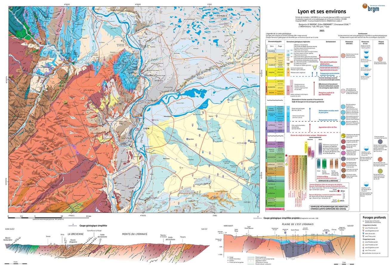
Educational, geological map of Lyon and its surrounding areas.
© BRGM
The occupation and layout of inhabited areas have always been determined by the geology of the near surface and deep subsurface. BRGM (the French Geological Survey) publishes an educational, geological map to help people understand the importance of this. Unlike traditional maps, the innovative legend enables you to understand the chronological sequence of the main events that led to the formation and structure of different masses of rock. The legend also includes information about the past and present uses of the mineral resources beneath our feet, the layers that contain groundwater and the areas in which there are potential geological risks. In order to get a better idea of the three-dimensional layout of the land, a series of section diagrams show the land in slices.
The map was produced using geological maps at a scale of 1:50,000, which are the reference documents used by geologists today. It draws on new data collected during field observations and drilling operations. The map published by BRGM is based on reliable, up-to-date geological knowledge.
Three geological domains identified for Lyon and its surrounding areas
The capital of the Auvergne-Rhône-Alpes region sits between two very distinct geological domains. To the west, the edge of the bedrock of Massif Central is essentially made up of metamorphic rocks, which represent the former deep section of the Hercynian mountain chain and form the backbone of the Monts du Lyonnais (Lyon Mountains); certain specific areas are covered by marine sediments of the Mesozoic Era (Monts d'Or range), and recent Quaternary glacial and periglacial deposits (moraines of the Fourvière and Croix-Rousse hills). To the east, the Tertiary molasse basin, which extends from the Bresse region to the Bas-Dauphiné, is mainly made up of molasse sediments (sands and sandstones) deposited on the bedrock and its eroded Mesozoic cover, and of more recent deposits from the Quaternary era.
Roughly dividing the two previous domains, a third, more linear and localised domain has recently been distinguished. It is a network of valleys or canyons formed in the Messinian age (end of the Miocene period) when the Mediterranean underwent a phase of dramatic drying, and subsequently filled in by marine and then fluvial sediments in the Pliocene age.
The map helps people to understand why the oldest plots of land are now located in the most raised topographic positions, and how the structures and geological history of the central domain are linked to those of the Alpine domain. This geological picture makes it easier to understand the preferred locations for crops and the different areas of Lyon's progressive urbanisation. It shows how the course of the former river valleys has determined abrupt lateral changes in the nature of the rocks in the subsurface and how these contrasts have impacted (and will impact) the tunnels under the hills of the conurbation.
Produced by the best specialists in the sector – from BRGM, the Ecole Normale Supérieure de Lyon and Egis – this map was printed on a special paper that is water-resistant and crease-proof.
Additional information
Educational geological map of Lyon and its surrounding areas - 89 x 63 cm - €14


