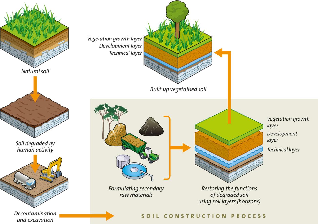
Diagram showing how soil is regenerated for restoring wastelands (INRA/INPL/TVD Patent).
© BRGM
20 years of soil inventories and monitoring: the objectives and results of GIS Sol's work
To mark its 20th anniversary, the French Scientific Interest Group on Soils (Groupement d'intérêt scientifique sur les sols, GIS Sol) – a consortium that brings together the Ministry of Agriculture and Food, the Ministry of Ecological Transition, ADEME, BRGM, IGN, INRAE, IRD and OFB – held a day of meetings and discussions to review its soil-inventory and monitoring actions and set out its future roadmap.
The day brought together nearly 300 representatives from a variety of sectors (research, agriculture, forestry, associations, decision-making bodies, and other stakeholders). It underlined the way in which GIS Sol has and can continue to contribute to establishing new public policies (notably for agriculture and forestry) in relation to spatial planning, biodiversity management and climate-change mitigation, in order to respond to the various environmental, climate-related and public-health issues that society must deal with.
While soils are obviously one of the pillars of our food supply, they also contribute to protecting water resources (in terms of both quantity and quality) and terrestrial biodiversity and help regulate the climate. However, they are also exposed to several natural or anthropogenic threats: loss of organic matter, erosion, pollution, soil sealing, etc. It is estimated that between one and two thirds of soils in Europe and worldwide are currently degraded. The percentage could increase by 2050 if no action is taken.

Soils are an ecosystem in themselves, a living environment. Protecting soils means ensuring the balance of other ecosystems, to which they provide resources and support. The work carried out by GIS Sol is therefore essential, at a national and even European level. We are still at the beginning!
GIS Sol, from acquiring samples to developing operational soil-quality indicators
Various international, European, national and local organisations are actively involved in soil protection and rehabilitation. However, acquiring a better understanding of the soil and monitoring its quality over time are essential in order to efficiently protect our soils. GIS Sol has been working towards this goal since 2001, acquiring soil samples (there are 75,000 in the French Soil Conservatory) and data on soil properties, while gradually building operational soil-quality indicators to support public policy-making and private stakeholders.
There is an ever-increasing number of requests for soil datasets on the GIS Sol website: more than 7,000 downloads of 15 datasets, and almost 1 million views of 159 maps in 2020. These results were achieved by setting up robust research programmes and several partnerships, and by conducting extensive fieldwork. The GIS Sol soil map, which is the French benchmark as regards soil knowledge and sustainable management, has been incorporated in the Géoportail operated by the IGN.
The programme for the day was perfectly in line with the new European mission entitled "Caring for Soil is Caring for Life" and the launch of the new European Soil Observatory (EUSO) with which GIS Sol interacts. It notably comprised:
- a review of the data and samples collected by GIS Sol and an assessment of their value in terms of meeting several different objectives:
- agricultural: demarcation of less-favoured areas (LFA) and regional food-production projects in the framework of the Common Agricultural Policy
- forestry-related: development of the sector
- environmental: protection of soil biodiversity, protection of water quality and wetlands
- climate-change-related: organic carbon storage in soils and greenhouse gas emissions
- health-related: environmental contamination
- spatial planning: land quality and soil sealing (artificial surfaces)
- an outline of the prospects opened up by new technologies (sensors, models, remote sensing), and the use of participatory science (data acquired with or thanks to the participation of non-experts in the field).
GIS Sol presented the results of an open survey on soil-data needs. The day also provided an opportunity to formally launch the SOLathon, a competition to create digital tools to improve the recording and dissemination of soil data. The results of the competition, which involves 7 candidate projects, will be available in mid-June 2022.

The work carried out by GIS Sol is extremely valuable because our soils (above and beyond their productive dimension) play a major role in responding to the challenges that society faces, with environmental issues being first and foremost among those. Indeed, our soils are real allies in the face of climate change!
Press contact


