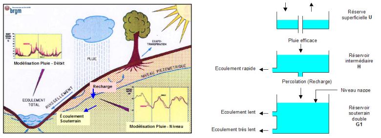
Schematic diagram of the GARDENIA model, and diagram with a groundwater reservoir comprising two outlets.
© BRGM
GARDENIA (acronym for Modèle Global À Réservoirs pour la simulation de DÉbits et de NIveaux Aquifères) uses meteorological data series related to catchment area (precipitation, potential evapotranspiration, air-temperature) to calculate:
- the flow rate at the outlet of a river (or spring);
- and / or the groundwater level at a given location in the underlying unconfined aquifer.
GARDENIA is an application for lumped hydrologic modelling. It simulates the main water cycle mechanisms in a catchment basin (rainfall, evapotranspiration, infiltration, runoff) by applying simplified physical laws for flow through successive reservoirs.
The calculations can be made at a daily, weekly, 10-day, or monthly time step. Users can also choose a much shorter time step, e.g. half-hourly or every five minutes.
Snowmelt can also be taken into account in the calculations.

Simulations made with the GARDENIA software.
© BRGM
Learn how to use GARDÉNIA
BRGM Formation is offering a course entitled “Global hydrodynamic modelling with the GARDÉNIA model (© BRGM)”.
This course, which is intended for engineers needing to determine hydrological budgets so as to determine the risks of low water or flooding and estimate the recharge of aquifers before hydrodynamic modelling of groundwater, can be delivered within companies, in France and abroad.
The advantages of the course
The GARDÉNIA software (Modèle Global À Réservoirs pour la simulation de DÉbits et de NIveaux Aquifères [Global model with reservoirs for simulating aquifer flows and levels]) is used for global hydrological modelling of a catchment basin based on Rainfall – River flow rate – Groundwater table.
The GARDENIA computer code is routinely used to extend data in both time and space. It can be used to:
- calculate the balance of rainfall, actual evapotranspiration, run-off and infiltration into the underlying aquifer,
- generate long series of flow rate or piezometric levels from historical rainfall data, after calibration for a relatively short period,
- analyse consistency between climate observations and observations of flow rates or piezometric levels.
The GARDENIA computing procedure is used in the MARTHE application to calculate run-off directed towards rivers and infiltration introduced into the vadose zone of the model, or into a shallow aquifer.
In practice, GARDENIA will analyse the hydrological functioning of a catchment basin and extend flow rates and / or levels data. It can therefore support the design of engineering works such as dams, or amenities such as car parks, water abstraction points in rivers, micro-powerplants, etc.
Once calibrated, the model will:
- for a given catchment basin, recreate the flow rates of a river or spring and/ or the piezometric levels at a given point in the aquifer during periods when measurements are not available,
- simulate:
- flow rates resulting from dry periods (due to low water periods or dam design) or exceptional precipitation sequences (design of foundations, car parks, underground engineering works),
- groundwater piezometric levels at a given moment on observed precipitation and extended to produce precipitation scenarios (drought or high water periods, etc.).
The GARDENIA computing code is designed for sequential processing of several basins, with common options. It is therefore a highly suitable tool for regional syntheses that require sufficiently consistent analyses of several catchment basins.
GARDENIA offers the following features:
- Simultaneous calibration of modelling parameters for series of flow rates measured at the outlet, and for series of piezometric levels at a representative point in a basin. This function significantly improves the reliability of calibration, compared to calibration with only river flow data or with only aquifer levels.
- Time series of pumping (or injection) flow rates in the catchment basin can be included in the calculations.
Working principle of the GARDENIA application
GARDENIA is an application for lumped hydrologic modelling. It simulates the main water cycle mechanisms in a catchment basin (rainfall, evapotranspiration, infiltration, run-off) by applying simplified laws of physics to flows through successive reservoirs.
Transfers from one reservoir to another are governed by simple laws described by the model's design parameters (retention capacity of the soil, transfer time, flooding thresholds, etc.).
Because of the global nature of the scheme and because of the complexity of the actual hydrological system, these parameters, although physically meaningful, cannot easily be deduced a priori from the physiographic characteristics of a basin at a given point (geology, plant cover, etc).
These parameters must therefore be determined either:
- by calibration to one or two series of observations,
- or, exceptionally, by transposition from models of nearby catchment basins with similar characteristics.
Data required to use GARDENIA
The following data are required to calibrate the parameters:
- continuous time series used as input: rainfall and evapotranspiration (and air temperature if snowmelt is taken into account),
- In some cases, a time series of water abstraction (or injection) flows in the basin
- one or two time series of observations (flow rates at the outlet and / or piezometric levels), not necessarily continuous but for the same period as the above series. The series (or two series) will be compared with the model output.
ÉROS software
The ÉROS software (Ensemble of Rivers Organized in Sub-basins) is a generalization of GARDÉNIA. It makes it possible to model a heterogeneous watershed in the form of a hierarchical cluster of GARDÉNIA models. Each GARDÉNIA model is applied to a sub-basin. ÉROS can also model nitrate transfers in each sub-basin.
To find out more

Downloadable documentation for GARDENIA
Note: Dialog box, inputs and outputs of the software are in English, however the documentation and help files are in French.
Tutorials
Instructions for use
Technical notes on complementary aspects
Publications on studies conducted with GARDENIA software



From left to right: Simulation of rainfall and water table levels at the CIEH piezometer (Ouagadougou - Burkina Faso). Simulation of rainfall and water table levels at the Saint Martin - Chennetron piezometer (Champigny limestone). Simulation at hourly intervals of flow rates in the "Rivière des Mats" basin on La Réunion island during six hurricanes from 2000 to 2003. Simulation at monthly intervals of flow rates in the Isère river at Val d'Isère from 1995 to 2005.The maximum flow rates in summer are accurately simulated thanks to the snowmelt module.