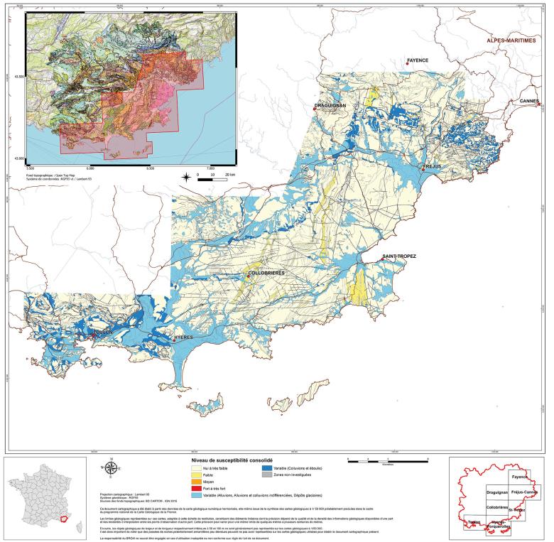
Map of consolidated asbestos susceptibility levels attributed to the geological formations of the Maures and Tanneron Massifs (2022)
© BRGM
The need
Preventing or mitigating health risks from environment-related pathologies is a major focus of the 3rd and 4th National Environmental Health Plans. In collaboration with the DGPR, which is attached to the Ministry for Ecological Transition and Territorial Cohesion, BRGM has been mapping potentially asbestos-rich areas since 2009 to help reduce exposure to natural asbestos outcrops. Initially launched in mainland France, this work has also been extended to the French overseas departments, territories and municipalities since 2022. The presence of natural asbestos is an emerging problem that at the very least requires the acquisition of new knowledge, public awareness raising and the implementation of appropriate and proportionate measures. In this context, the aim of projects to map the possible occurrence of asbestos in the natural environment is to acquire initial level of knowledge about the distribution of rocks that are likely to contain natural asbestos and make this knowledge available.
The results
The main asbestos-bearing occurrences are found in certain basic to ultrabasic metamorphic and magmatic rocks, mainly located in ancient or recent mountain ranges. These particular geological areas have already been assessed by experts (e.g. Massif Central, Armorican Massif, Alps, Pyrenees, Vosges, Corsica, etc.) and the Maures-Tanneron Massif is the latest example.
The work carried out by BRGM in the Maures-Tanneron region to map the possible occurrence of asbestos in the natural environment took place in three distinct phases. Firstly, a preliminary bibliographical study was carried out to determine the areas potentially affected by the problem. A field survey (geological mapping and sampling) was then carried out, followed by laboratory studies combining several analytical methods. The results of the study in the Maures-Tanneron region showed the presence of asbestos-bearing species in serpentinised peridotites and, more sporadically, in calcium silicate gneisses. Fibrous minerals that can break down into fine fibres (cleavage fragments) of amphibole (grunerite and/or actinolite) occur in several types of rock, including tonalites, amphibolites, gabbros and collobrierite (a rock named after the Collobrières region).

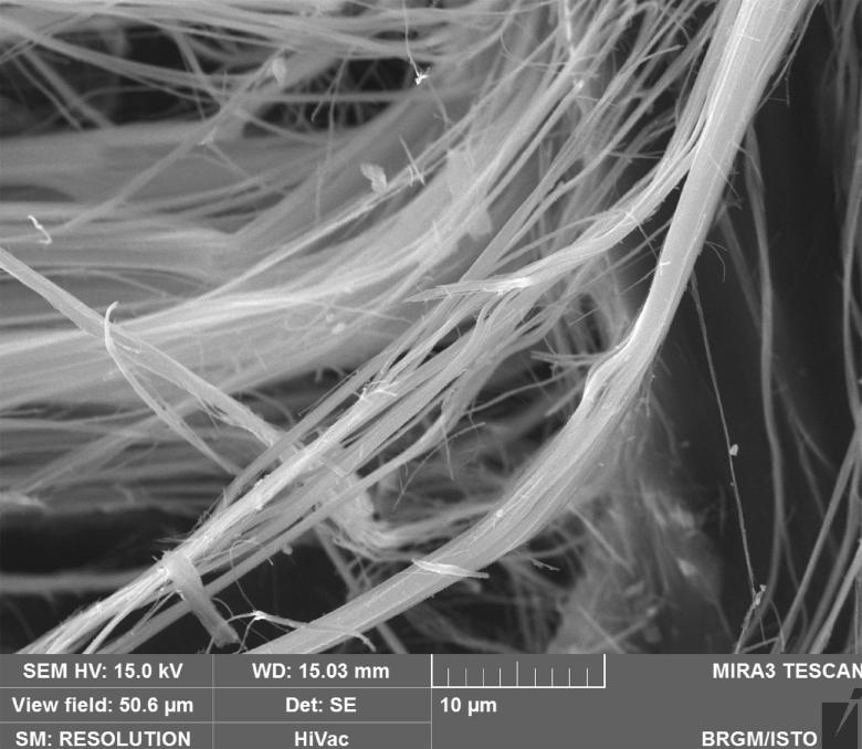
Secondary-electron microscopy image of asbestiform chrysotile fibres taken from the former Gorbière quarry (BRGM, 2021)
© BRGM
Using the results
All the documents produced by BRGM (maps of the possible occurrence of asbestos in the natural environment and associated reports) as part of this collaboration with the DGPR are disseminated and accessible on InfoTerre (link below). For each geological formation in the targeted study area (on a scale of 1:50,000), the maps show four levels of susceptibility to the presence of natural asbestos ("None to very low", "Low", "Medium" and "High to very high"). These documents contribute to and consolidate the knowledge base and should be consulted prior to any type of works/development in potentially asbestos-rich areas, particularly in the course of pre-works asbestos surveys in the soils and rocks on location, in accordance with NF P94-001.
The partners
- Ministry for Ecological Transition and Territorial Cohesion/DGPR/BSE (Health and Environment Office)


