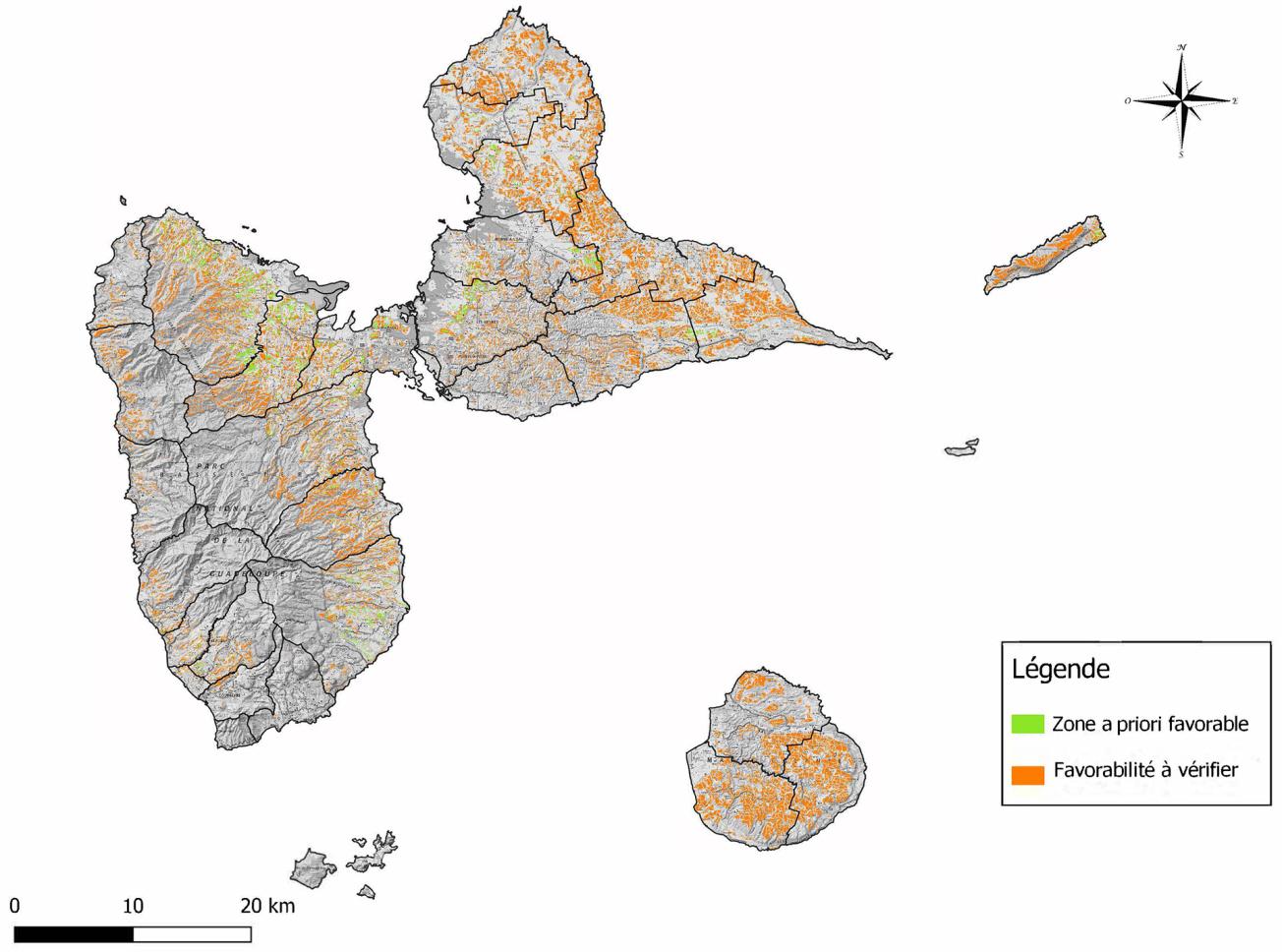
Map of potentially favourable areas for burying animal carcasses in Guadeloupe (2019).
© BRGM Guadeloupe
The need
The "EU Richter Caribbean 2017" exercise, conducted in Guadeloupe in March 2017, highlighted shortcomings in the emergency disposal of animal carcasses following high mortality. The preferred disposal route for this type of waste is still rendering, but suitable facilities could easily be overwhelmed in the event of a major crisis. The alternatives of incineration and burial should then be considered. The Guadeloupe Food, Agriculture and Forestry Department (DAAF) therefore asked BRGM to identify areas throughout Guadeloupe that are potentially suitable for burying animal carcasses.
The results
A cartographic decision-support tool in the form of a Geographic Information System (GIS) was thus developed to identify, throughout the Guadeloupe département, potentially favourable area (e.g. at a certain distance from urban areas) or unfavourable areas because of local constraints (e.g. proximity to a drinking water catchment, too steep a slope, etc.) . It should be noted that all landfill sites must be validated by a certified hydrogeologist.
The criteria were chosen after analysing the regulations, the administrative procedures, feedback from similar work carried out by BRGM in other départements and on the advice of experts. These criteria were then integrated into a multi-criteria analysis procedure.
In the end, the favourable zones, located in Grande-Terre, Basse-Terre and La Désirade, account for 1% of the Guadeloupe territory, whereas potential zones that still remain to be verified account for approximately 17% of the territory.
Using the results
The steering committee made up of the DAAF, the Interministerial Service for Defence and Civil Protection (SIDPC) and the Regional Health Agency (ARS) has helped guide BRGM's work towards the creation of an operational tool for all stakeholders. To date, the tool has not yet been used for a real crisis, but it should be used as part of a Health Emergency Response Plan (HERP or PISU in French) exercise scheduled for the coming months.
The work carried out by BRGM now enables the competent authorities and the certified hydrogeologist to determine the most suitable landfill site as quickly as possible.
The partners
- DAAF 971

During a natural disaster or an epizootic event, how do you deal with an influx of animal carcasses? Burying carcasses is the most effective solution if processing capacities are exceeded, but the areas selected must meet multi-criteria analyses and be approved by a certified hydrogeologist. Following a large-scale earthquake exercise, the government departments wanted to have a decision-support tool to identify the areas likely to be most suitable for burial of carcasses. The partnership between the DAAF and BRGM made it possible to achieve this goal.


