Project description and challenges
Active volcanoes in densely populated areas represent a major natural hazard that influences and guides the territory management policy and requires a strong and effective interplay of the societal components (science, engineering, policy makers). This has led to the implementation of in-situ volcano monitoring systems worldwide, as well as an increasing interest of Earth Observation (EO) missions to acquire geophysical and geochemical parameters linked to the volcanic activity.
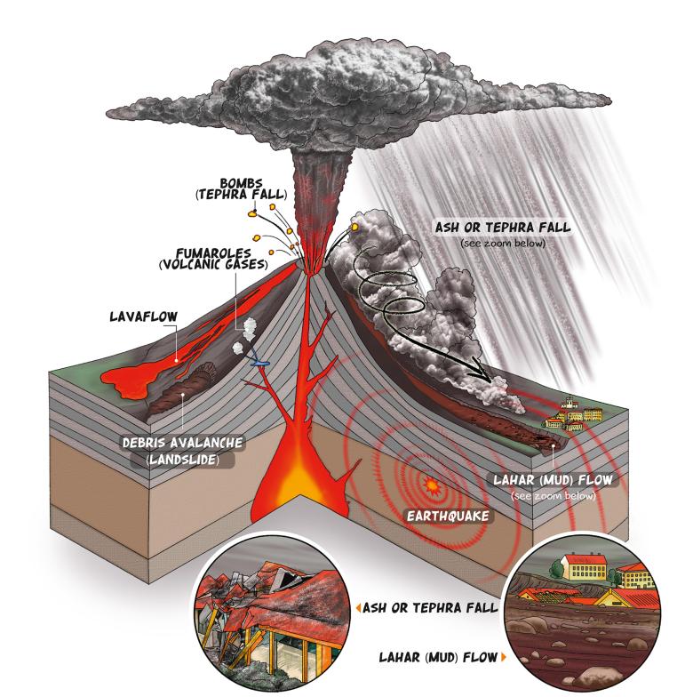
In Europe, the south of Italy is a clear example of such a situation, where various areas are threatened by virtually all types of volcanic hazards (from lava flows to tephra falls, pyroclastic flows, lahars, and widespread ash clouds affecting international air traffic). The metropolitan area of Naples (more than 2 million of inhabitants with a density > 2.600 inhabitants/km2) has grown within the Campi Flegrei caldera and around Vesuvius volcano ; both volcanoes have shown highly explosive volcanism throughout their geological histories and into historical time. A new eruption is expected to produce 10-30 km-high volcanic columns, ash cloud dispersal over substantial portions of Europe and beyond (depending on wind directions), and devastating pyroclastic flows. The area of Naples is one with the highest levels of volcanic risk worldwide also considering that, since the 1950s, a phase of unrest is under way in the Campi Flegrei caldera, whose macroscopic effects resemble those of phenomena that preceded its most recent eruption in 1538. Therefore, a volcanic eruption would have the potential to cause a crisis of European proportions.
The challenge from future eruptions in this densely populated area requires the most avant-garde monitoring methods and techniques to be applied, in order to capture and correctly interpret premonitory signs of unrest in time to permit an adequate response. This Task is rather delicate also because of the risk of a false alarm that could cause partial to total disruption of social, cultural, and economic life and bring hardship to an exceptionally large number of people. Conversely, late warning of an unusually rapid eruption onset can result in a rather chaotic response, with a high risk of economic and human losses.
Results and uses
During the three-year project, MED-SUV yielded several breakthroughs in monitoring, studying and modelling the volcanic processes and the related phenomena, as well as in assessing the potential hazards in the Italian volcanic areas. n particular, the main achievements were:
- Appointing of Mt. Etna and Campi Flegrei / Vesuvius as permanent Supersites: this implies the matching of GEO-GSLN guidelines on data accessibility and continuity of both in-situ and EO data provision;
- Integration: multidisciplinary data sets, from in-situ and EO system, have been merged to obtain new information;
- New knowledge on volcanic structures and processes: investigations into the volcano plumbing system and its dynamics, on the characterization of the surface phenomena (e.g. lava and pyroclastic flows, explosive activity) and their interaction with the environment (e.g. volcanic plumes);
- New tools for monitoring and hazard assessment, awareness and preparedness: technological innovations involving European industrial partnership; exploitation of new knowledge for making steps forward in hazard assessment and implementation of new tools; engagement of local decision-makers in charge of risk management; implementation of dissemination tools (e.g. leaflets); and carrying out appropriate educational activities in schools;
- Applicability of the new volcanology findings and of the novel technological products: the project outcomes were tested and validated at other European volcanic areas (Azores and Piton de la Fournaise) and it was also argued whether they might have been suitable for the monitoring and study of further basaltic volcanoes (i.e.Kilauea volcano, Hawai'i);
- Data and product accessibility: the project set up a website and an e-infrastructure for accessing to data and products; this is the result of a complex tuning of several activities, e.g. data base standardization and interoperability, data policy implementation.
The role of BRGM
Raising awareness among young people about volcanic risks
As part of the European MED-SUV project concerning the management of volcanic risks in southern Italy, BRGM has produced educational brochures to make young people more aware of these issues.
With the support of the INGV, the DLR (the German National Aeronautics and Space Research Centre) and the DPC (the Italian Civil Protection Department), BRGM has produced a range of educational materials for schools to raise awareness about volcanic risks. These tools notably present the volcano monitoring systems in place and provide advice on how to be properly prepared for an eruption.
The aim of the brochures and posters is also to stimulate school pupils' curiosity about the different types and shapes of volcanoes. The content of the tools was designed in response to preliminary results from in-school activities organised by the University of Granada (Spain), which showed that over 90% of the pupils interviewed imaged volcanoes as having a conical shape.
The educational materials are available in six languages (English, French, German, Italian, Portuguese and Spanish).
A three-dimensional map of the volcanic ash plume derived from Landsat 8 satellite
In parallel, Dr. Marcello de Michele and Dr. Daniel Raucoules (BRGM) and their team used the Landsat 8 satellite to extract a three-dimensional map of the volcanic ash plume.
Consortium
The MED-SUV consortium brough together institutions and companies having the needed experiences and expertise for the achievement of the project objectives, organized in a synergetic way. Together, these scientific and industrial partners as well as public agencies with long and well-assessed experiences formed a consortium able to cover the whole volcanic risk management cycle, from observations to public communication. In addition to the remarkable human resources that make up the consortium, the partners also brough critical infrastructure into play, with world class monitoring networks, laboratories, computer facilities, etc.
- ISTITUTO NAZIONALE DI GEOFISICA E VULCANOLOGIA (Coordinator) – INGV – Italy
- CONSIGLIO NAZIONALE DELLE RICERCHE – CNR – Italy
- AMRA - ANALISI E MONITORAGGIO DEL R ISCHIO AMBIENTALE SCARL – AMRA – Italy
- PRESIDENZA DEL CONSIGLIO DEI MINISTRI - DIPARTIMENTO DELLA PROTEZIONE CIVILE – DPC – Italy
- DEUTSCHES ZENTRUM FUER LUFT - UND RAUMFAHRT EV – DLR – Germany
- LUDWIG-MAXIMILIANS-UNIVERSITAET MUENCHEN – LMU – Germany
- Helmholtz-Zentrum Potsdam Deutsches GeoForschungsZentrum – GFZ – Germany
- UNIVERSITY OF DURHAM – UDUR – United Kingdom
- UNIVERSITY OF BRISTOL – UNIVBRIS – United Kingdom
- CENTRE NATIONAL DE LA RECHERCHE SCIENTIFIQUE – CNRS – France
- BUREAU DE RECHERCHES GEOLOGIQUES ET MINIERES – BRGM – France
- EUROPEAN SPACE AGENCY – ESA – Italy
- AGENCIA ESTATAL CONSEJO SUPERIOR DE INVESTIGACIONES CIENTIFICAS – CSIC – Spain
- UNIVERSIDAD DE GRANADA – UGR – Spain
- Universidade dos Açores – UAC – Portugal
- UNIVERSITA TA MALTA – UoM – Malta
- SURVEY LAB – Surveylab – Italy
- MARWAN TECHNOLOGY – MATEC – Italy
- TERRADUE UK LTD – T2 – United Kingdom
- THE UNIVERSITY OF WESTERN ONTARIO – Western – Canada
- UNITED STATES GEOLOGICAL SURVEY – USGS - HVO – United States
- UNIVERSITA DEGLI STUDI DI MILANO – UMIL – Italy
- DELTAG SRL – DELTAG – Italy
- UNIVERSITE BLAISE PASCAL CLERMONT-FERRAND II – UBP-LMV – France
Educational material
The leaflet and poster are available in 6 languages :
- English:
- French:
- German:
- Italian:
- Portuguese:
- Spanish:
Publications
2016
- Barberi,G., Giampiccolo, E., Musumeci, C., Scarfi, L., Bruno, V., Cocina, O., Díaz-Moreno, A., Sicali, S., Tusa, G., Tuvè, T., Zuccarello, L., Ibáñez J.M., and Patanè, D. (2016) Seismic and Volcanic activity during 2014 in the región involved by TOMO-ETNA seismic active experiment. Annals of geophysics, 59, 4, 2016, S0429 ; doi:10.4401/ag-7082
- Brancato A., Buscema P.M., Massini G., Gresta S. (2016) Pattern Recognition for Flank Eruption Forecasting : An Application at Mount Etna Volcano (Sicily, Italy). Open Journal of Geology, 2016, 6, 583-597, doi : 10.4236/ojg.2016.67046
- Cavallaro, D., Cocchi, L., Coltelli, M., Muccini, F., Carmisciano, C., Firetto-Carlino, M., Ibáñez, J.M., Patanè, D., Filippone, M. and Buttaro, E. (2016) Acquisition procedures, processing methodologies and preliminary results of magnetic and ROV data collected during the TOMO-ETNA experiment. Annals of geophysics, 59, 4, 2016, S0431 ; doi:10.4401/ag-7084
- Coltelli, M., Cavallaro, D., Firetto Carlino, M., Cocchi, L., Muccini, F., D’alessandro, A., Claude, M.E, Monaco, C., Ibànez, J.M. and Rapisarda, S (2016) The marine activities performed within the TOMO-ETNA experiment. Annals of geophysics, 59, 4, 2016, S0428 ; doi:10.4401/ag-7081
- Costa A., Pioli L., Bonadonna C. (2016) Assessing tephra total grain-size distribution : Insights from field data analysis. Volume 443, 1 June 2016, Pages 90–107 ; doi:10.1016/j.epsl.2016.02.040
- Costa A. , Suzuki Y. J., Cerminara M., Devenish B., Esposti Ongaro T., Herzog M., Van Eaton A., Denby L.C., Bursik M., de Michieli Vitturi M., Engwell S., Neri A., Barsotti S., Folch A., Macedonio G., Girault F., Carazzo G., Tait S., Kaminski E., Mastin L., Woodhouse M., (2016) Results of the eruption column model inter-comparison study. Journal of Volcanology and Geothermal Research, in Press ; doi:10.1016/j.jvolgeores.2016.01.017
- De Michele M., Raucoules D. and Arason Þ. (2016) Volcanic Plume Elevation Model and its velocity derived from Landsat 8. Remote Sensing of Environment 176 (2016) 219–224 ; doi:10.1016/j.rse.2016.01.024
- Díaz-Moreno A., Koulakov I., García-Yeguas A., Jakovlev A., Barberi, G., Cocina O., Zuccarello L., Scarfì, L., Patanè. D. , Álvarez I., García L., Benítez C., Prudencio J. , Ibáñez J.M. (2016) PARTOS - Passive and Active Ray TOmography Software : Description and preliminary analysis using TOMO-ETNA experiment’s dataset. Annals of geophysics, 59, 4, 2016, S0435 ; doi:10.4401/ag-7088
- Firetto-Carlino, M., Zgur, F., Bruno, P.P., Coltelli, M., Sormani, L., Cavallaro, D., Ibáñez, J.M. and Patanè, D. (2016) Acquisition and preliminary analysis of multi-channel seismic reflection data, acquired during the oceanographic cruises of the Tomo-Etna experiment. Annals of geophysics, 59, 4, 2016, S0430 ; doi:10.4401/ag-7083
- Folch A., Costa A., Macedonio G. (2016) FPLUME-1.0 : An integral volcanic plume model accounting for ash aggregation. Geosci. Model Dev., 9, 431-450, 2016 ; doi:10.5194/gmd-9-431-2016
- García, L., Álvarez I., Benítez, C., Titos, M., Bueno, M., Mota, S., De la Torre, A., Alguacil, G., Díaz-Moreno, A., Prudencio, J., García-Yeguas, A., Ibáñez, J.M., Zuccarello, L., Cocina, O., and Patané, D. (2016) Advances on the automatic estimation of the P-wave onset time. Annals of geophysics, 59, 4, 2016, S0434 ; doi:10.4401/ag-7087
- Ibáñez J.M., Prudencio J., Díaz-Moreno A., Patané D., Puglisi G., Luehr B.G., Carrión F., Dañobeitia J.J., Coltelli M., Bianco F., Del Pezzo E., Dahm T., Willmott V., Mazauric V. (2016) The TOMO-ETNA experiment : an imaging active campaign at Mt. Etna volcano. Context, main objectives, working-plans and involved research projects. Annals of geophysics, 59, 4, 2016, S0426 ; doi:10.4401/ag-7079
- Ibáñez J.M. et al. (2016) TOMO-ETNA experiment at Etna volcano : activities on land. Annals of geophysics, 59, 4, 2016, S0427 ; doi:10.4401/ag-7080
- Macedonio G., Costa A., Folch A. (2016) Uncertainties in volcanic plume modeling : A parametric study using FPLUME Journal of Volcanology and Geothermal Research, in Press, doi:10.1016/j.jvolgeores.2016.03.016
- Macedonio G., Costa A., , Scollo S., Neri A. (2016) Effects of eruption source parameter variation and meteorological dataset on tephra fallout hazard assessment : an example from Vesuvius (Italy). Journal of Applied Volcanology (2016) 5:5 ; doi : 10.1186/s13617-016-0045-2
- Marti A., Folch A., Costa A., Engwell A. (2016) Reconstructing the plinian and co-ignimbrite sources of large volcanic eruptions : a novel approach for the Campanian Ignimbrite. Scientific Reports 6, Article number : 21220 ; doi:10.1038/srep21220
- Monaco, C., Ibáñez, J.M., Carrión, F. and Tringali, L. M. (2016) Cetacean behavioural responses to noise exposure generated by seismic surveys : how to mitigate better ? Annals of geophysics, 59, 4, 2016, S0436 ; doi:10.4401/ag-7089
- Polcari M., Palano M., Fernández J., Samsonov S., Stramondo S., and Zerbini S. (2016) 3D displacement field retrieved by integrating Sentinel-1 InSAR and GPS data : the 2014 South Napa earthquake European Journal of Remote Sensing - 2016, 49 : 1-13 ; doi : 10.5721/EuJRS20164901
- Sandri L., Costa A. , Selva J., Tonini R., Macedonio G., Folch A., Sulpizio R. (2016) Beyond eruptive scenarios : assessing tephra fallout hazard from Neapolitan volcanoes. Scientific Reports 6, Article number : 24271 ; doi : 10.1038/srep24271
- Tierz P., Sandri L., Costa A., Sulpizio R., Zaccarelli L., Di Vito M.A., Marzocchi W. (2016) Uncertainty assessment of Pyroclastic Density Currents at Mt Vesuvius (Italy) simulated through the Energy Cone Model. AGU Books, in Press
- Zieger T., Sens-Schönfelder C., Ritter J.R.R., Lühr B.G., Dahm T. (2016) P-wave scattering and the distribution of heterogeneity around Etna Volcano. Annals of geophysics, 59, 4, 2016, S0432 ; doi:10.4401/ag-7085
- Zuccarello, L., Paratore, M., La Rocca, M., Ferrari, F., Messina, A., Branca, S., Contrafatto, D., Galluzzo, D., Rapisarda, S., García, L. (2016)
- Shallow velocity model in the area of Pozzo Pitarrone, Mt. Etna, from single station, array methods and borehole data. Annals of geophysics, 59, 4, 2016, S0433 ; doi:10.4401/ag-7086
2015
- Bonadonna C., Biass S., Costa A. (2015) Physical characterization of explosive volcanic eruptions based on tephra deposits : propagation of uncertainties and sensitivity analysis. Journal of Volcanology and Geothermal Research, Volume 296, 15 April 2015, Pages 80–100 ; doi:10.1016/j.jvolgeores.2015.03.009
- Bonforte, A. & Guglielmino, F. 52015) Very shallow dyke intrusion and potential slope failure imaged by ground deformation : The 28 December 2014 eruption on Mount Etna. Geophys. Res. Lett., 42,2727–2733, doi:10.1002/2015GL063462
- Cannavò, F., Camacho, A. G., González, P. J., Mattia, M., Puglisi, G., & Fernández, J. (2015). Real Time Tracking of Magmatic Intrusions by means of Ground Deformation Modeling during Volcanic Crises. Scientific reports, 5. doi:10.1038/srep10970
- Chiodini, G., Vandemeulebrouck, J., Caliro, S., D’Auria, L., De Martino, P., Mangiacapra, A., Petrillo, Z. (2015). Evidence of thermal-driven processes triggering the 2005-2014 unrest at Campi Flegrei caldera. EPSL, 414, , 58, 67, doi : 10.1016/j.epsl.2015.01.012
- Chiodini G., Pappalardo L., Aiuppa A., and S. Caliro (2015). The geological CO2 degassing history of a long-lived caldera. Geology published online on 17 July 2015, doi:10.1130/G36905.1
- D’Auria, L., Pepe, S., Castaldo, R., Giudicepietro, F., Macedonio, G., Ricciolino, P., Tizzani, P., Casu, F., Lanari, R., Manzo, M., Martini, M., Sansosti, E., & Zinno, I. (2015) Magma injection beneath the urban area of Naples : a new mechanism for the 2012–2013 volcanic unrest at Campi Flegrei caldera. Scientific Reports 5, Article number : 13100 ; doi:10.1038/srep13100
- Di Muro A., Métrich N., Allard P., Staudacher T., Aiuppa A., Burton M., Galle B. (2015) Magma degassing at Piton de la Fournaise volcano. In : Active Volcanoes of the Southwest Indian Ocean. Active Volcanoes of the World, 203-222 ; Doi : 10.1007/978-3-642-31395-0-12
- Falsaperla, S. and Neri, M (2015). Seismic footprints of shallow dyke propagation at Etna, Italy.. Sci. Rep. 5, 11908 ; doi : 10.1038/srep11908
- Imperatore, P., Pepe, A., & Lanari, R., (2015) Multichannel Phase Unwrapping : Problem Topology. IEEE transactions on geoscience and remote sensing, Volume:53 Issue:10, 5774 - 5793 ; Doi : 10.1109/TGRS.2015.2430619
- Silva C., Viveiros F., Ferreira T., Gaspar J.L., Allard P. (2015) Diffuse soil emanations of radon and hazard implications at Furnas Volcano, São Miguel Island (Azores). Geological Society London Memoirs, 09/2015 ; 44:197-211. Doi : 10.1144/M44.15
- Tonini C., Sandri L., Costa A., Selva J. (2015). Brief Communication : The effect of submerged vents on probabilistic hazard assessment for tephra fallout. Nat. Hazards Earth Syst. Sci., 15, 409-415, 2015 ; doi:10.5194/nhess-15-409-2015
- Viveiros, F., Ferreira, T., Silva, C., Vieira, J.C., Gaspar, J.L., Virgili, G., Amaral, P. (2015) Permanent monitoring of soil CO2 degassing at Furnas and Fogo volcanoes (São Miguel Island, Azores) Geological Society London Memoirs 44(1):271-288 ; doi : 10.1144/M44.20
2014
- Byrdina, S., Vandemeulebrouck, J., Cardellini, C., Legaz, A., Camerlynck, C., Chiodini, G., Lebourg, T., Gresse, M., Bascou, P., Motos, G., Carrier, A. and Caliro S. (2014). Relations between electrical resistivity, carbon dioxide flux, and self-potential in the shallow hydrothermal system of Solfatara (Phlegrean Fields, Italy). J. Volcanol. Geotherm. Res., 283,DOI:10.1016/j.jvolgeores.2014.07.010.
- Carbone, D., Aloisi, M., Vinciguerra, S. and Puglisi, G. (2014). Stress, strain and mass changes at Mt. Etna during the period between the 1991–93 and 2001 flank eruptions. Earth-Science Reviews, Volume 138, November 2014, Pages 454–468 ; doi:10.1016/j.earscirev.2014.07.004.
- Cortés, G., García, L., Alvarez, I., Benítez, C., De la Torre, A. and Ibáñez, J.M. (2014). Parallel System Architecture (PSA) : An efficient approach for automatic recognition of volcano-seismic events. Journal of Volcanology and Geothermal Research, Volume 271, 1 February 2014, Pages 1-10, ISSN 0377-0273
- D’Auria, L., Massa, B., Cristiano, E., Del Gaudio, C., Giudicepietro, F., Ricciardi, G. and Ricco C. (2014). Retrieving the Stress Field Within the Campi Flegrei Caldera (Southern Italy) Through an Integrated Geodetical and Seismological Approach. Pure and Applied Geophysics, December 2014 ; doi : 10.1007/s00024-014-1004-7
- Del Pezzo, E., Bianco, F., Giampiccolo, E., Tusa, G. and Tuvé, T. (2014). A reappraisal of seismic Q evaluated at Mt. Etna volcano. Receipt for the application to risk analysis. Journal of Seismology,
- Volume 19, Issue 1, pp 105-119 January 2015 ; doi : 10.1007/s10950-014-9453-0
- García-Yeguas, A., Ibáñez, J.M., Koulakov, I., Jakovlev, A., Romero-Ruiz, M.C. and Prudencio, J. (2014). Seismic tomography model reveals mantle magma sources of recent volcanic activity at El Hierro Island (Canary Islands, Spain). Geophysical Journal, Volume 199, Issue 3, p.1739-1750 ; doi : 10.1093/gji/ggu339
- Gottsmann, J. and Odbert, H.M. (2014). The effects of thermo-mechanical heterogeneities in island-arc crust on time-dependent pre-eruptive stresses and the failure of an andesitic reservoir. Journal of Geophysical Research : Solid Earth, Volume 119, Issue 6, pages 4626–4639, June 2014 ; doi : 10.1002/2014JB011079
- Hickey, J. and Gottsmann, J. (2014). Benchmarking and developing numerical Finite Element models of volcanic deformation. Journal of Volcanology and Geothermal Research , Volume 280, 1 June 2014, Pages 126–130 ; doi:10.1016/j.jvolgeores.2014.05.011
- Macedonio G., Giudicepietro F., D’Auria L. and Martini M. (2014). Sill intrusion as a source mechanism of unrest at volcanic calderas.Journal of Geophysical Research : Solid Earth, Volume 119, Issue 5, pages 3986–4000, May 2014 ; doi : 10.1002/2013JB010868
- Marsella, M., Nardinocchi, C., Proietti, C., Daga, L. and Coltelli, M. (2014). Monitoring Active Volcanos Using Aerial Images and the orthoview Tool. Remote Sens. 2014, 6, 12166-12186 ; doi:10.3390/rs61212166
- Pichavant, M., Scaillet, B., Pommier, A., Iacono-Marziano, A., and Cioni, R. (2014). Nature and crustal evolution of primitive Vesuvius magmas : an experimental study. J. Petrology (2014) 55 (11) : 2281-2310. doi : 10.1093/petrology/egu057
- Samsonov, S. V., K. F. Tiampo, A. G. Camacho, J. Fernández, and P. J. González (2014), Spatiotemporal analysis and interpretation of 1993–
- 2013 ground deformation at Campi Flegrei, Italy, observed by advanced DInSAR, Geophys. Res. Lett., 41, 6101–6108, doi:10.1002/2014GL060595.
- Samsonov, S.V., Trishchenko, A.P., Tiampo, K., González, P.J., Zhang, Y. and Fernández, J. (2014).Removal of systematic seasonal atmospheric signal from interferometric synthetic aperture radar ground deformation time series. Geophysical Research Letters, Volume 41, Issue 17, pages 6123–6130, 16 September 2014 ; doi : 10.1002/2014GL061307
- Scollo, S., Prestifilippo, M., Pecora, E., Corradini, S., Merucci, L., Spata, G., Coltelli, M. (2014). Eruption column height estimation of the 2011-2013 Etna lava fountains. Annals of Geophysics , 57, 2, 2014, S0214 ; doi:10.4401/ag-6396
- Selva J., Costa A., Sandri L., Macedonio G., Marzocchi W. (2014). Probabilistic short-term volcanic hazard in phases of unrest : A case study for tephra fallout. Journal of Geophysical Research, Volume 119, Issue 12, December 2014, Pages 8805–8826 ; doi : 10.1002/2014JB011252
- Viveiros, F., Vandemeulebrouck, J. , Rinaldi, A. P., Ferreira, T., Silva, C. and Cruz, J. V. (2014). Periodic behavior of soil CO2 emissions in diffuse degassing areas of the Azores archipelago. Application to seismo-volcanic monitoring. Journal of Geophysical Research : Solid Earth, Volume 119, Issue 10, pages 7578–7597, October 2014 ; doi : 10.1002/2014JB011118
2013
- Del Pezzo, E., & Bianco, F. (2013). Inside Mt. Vesuvius : a new method to look at the seismic (velocity and attenuation) tomographic imaging. Annals Of Geophysics, 56(4), S0443. doi:10.4401/ag-6449
- Del Pezzo, E., Chiodini, G., Caliro, S., Bianco, F., & Avino, R. (2013). New insights into Mt. Vesuvius hydrothermal system and its dynamic based on a critical review of seismic tomography and geochemical features. Annals Of Geophysics, 56(4), S0444. doi:10.4401/ag-6450
- Prudencio, J., Del Pezzo, E., García-Yeguas, A., Ibáñez, J.M. (2013). Spatial distribution of intrinsic and scattering seismic attenuation in active volcanic islands – I : model and the case of Tenerife Island. Geophys. J. Int. (December, 2013) 195 (3) : 1942-1956. doi : 10.1093/gji/ggt361
- Prudencio, J., Ibáñez, J.M., García-Yeguas, A., Del Pezzo, E. and A. Posadas (2013). Spatial distribution of intrinsic and scattering seismic attenuation in active volcanic islands – II : Deception Island image. Geophys. J. Int. (December, 2013) 195 (3) : 1957-1969. doi : 10.1093/gji/ggt360


