Dem'Eaux: understanding water issues in the Roussillon plain, around Perpignan
Located between the sea and the mountains in an area where water needs are growing and affecting the available resources, this groundwater resource was studied through to the end of 2021 in order to better understand its properties and constraints in the context of climate change.
The ultimate objective of this project, entitled Dem'Eaux Roussillon, was to gain a better understanding of the volumes of water that can be sustainably abstracted from the different layers of the aquifer. The project produced a large amount of knowledge on various topics, presented in the project outputs.
Strategic framework
Groundwater provides 90% of the drinking water supply in the former Languedoc-Roussillon region. It represents a major challenge, particularly with regard to climate change.
The karst and multi-layered sedimentary systems from which this resource is pumped are representative of the main aquifers exploited around the Mediterranean and in other regions of the world. Accordingly, the development of tools to optimise the use of these aquifers has the potential to generate international activities for the region's laboratories and companies.
The Dem'Eaux Roussillon project demonstrates solutions for the characterisation and concerted management of the water resources of the Roussillon multi-layer Pliocene-Quaternary sedimentary system.
The development of tools and methods for characterising and managing the Roussillon aquifer on the basis of the skills and know-how of the region's public research establishments and companies has contributed to their mutual technological and scientific development and has improved their visibility.

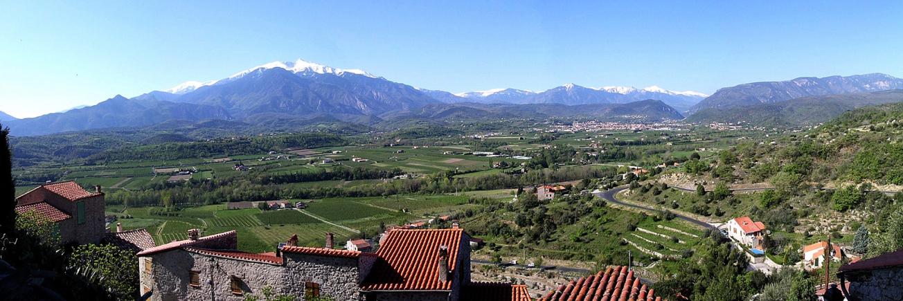
The Roussillon plain is bordered by the Pyrenees to the west, the Corbières massif to the north and the Mediterranean to the east.
© Laura Baillet
Background and objectives
Located on the coastal margin of the Pyrénées-Orientales département, the Roussillon plain is one of the driest regions in France with annual rainfall of 570 mm (average over the 1980-2010 period). Nevertheless, this area has a high level of urban development (the Perpignan agglomeration and coastal resorts) and agricultural development (approximately 15,000 ha of fruit and vegetable crops). Much of this development was made possible by the underground water resources contained in the Pliocene-Quaternary formations of the Roussillon plain.

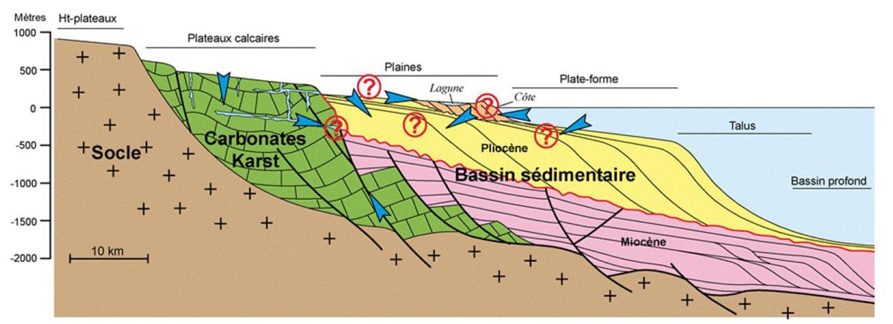
Situation of sedimentary aquifers and interactions with their environment. The question marks illustrate the main issues and interactions involved in the Pliocene-Quaternary aquifer.
© Duvail & Aunay, 2005
Abstraction from the water resource contained in the Pliocene-Quaternary aquifers currently amounts to 80 million m3/year (SAGE Roussillon, 2012). This abstraction has steadily depleted the aquifer over the entire plain. In order to deal with this, the local water management stakeholders created a Water Development and Management Scheme (SAGE "Nappes Plio-Quaternaires de la plaine du Roussillon") in 2008 to achieve a satisfactory groundwater status (this objective was set by the Water Framework Directive (WFD) for 2015) and rational water resource management.
Despite the technical and scientific work carried out to date (including a research project financed by the ANR – VULCAIN – and a study carried out in 2012 to determine the volumes that can be abstracted), the complexity of this aquifer (in terms of the geometry of the deposits, the organisation of water flows and the relationship with the interfaces) and the multiple issues at stake (numerous uncontrolled abstraction points, intense summer abstraction and problems with localised and diffuse pollution) mean that the conditions for the protection and the optimum, rational use of this aquifer are not well known at present.
Although the deep water in this aquifer (located largely under an impermeable cover) is not considered particularly vulnerable to human and agricultural activities, several catchments are affected by nitrate and pesticide pollution. This contamination is often attributed mainly to defective boreholes which connect shallow aquifers with the deep Pliocene aquifers, but this has not been documented with certainty.
In addition to this anthropogenic pollution, there is also the risk of seawater intrusion into the horizons exploited along the coast. Coupled with a chronic drop in piezometric levels throughout the plain, the scale of abstraction during the summer periods creates a risk of saline intrusion which could affect the entire water resource. Finally, existing climate projections (decreased recharge and rise in sea level) and the demand for water due to sustained population growth will probably exacerbate the existing pressure on this resource in the future.
The Dem'Eaux Roussillon project has combined expert regional knowledge in geology, geophysics, geochemistry, hydraulics, economics, electronics, spatial imagery and computer science to overcome the barriers to understanding the behaviour of the Roussillon Pliocene-Quaternary aquifer by taking into account all of the natural and anthropic issues associated with it and their future trends.
Work programme
The Dem'Eaux Roussillon project has proposed a multidisciplinary approach involving numerous areas of expert scientific knowledge needed to study the selected reservoirs, available in the Occitania region. It has substantially improved our understanding of the way the Pliocene-Quaternary aquifers work and of their hydraulic relationships with the natural systems (surrounding mountain ranges, rivers, sea) or anthropic systems (irrigation channels, water uses) with which they interact. This project has thus made an important contribution to optimising the protection and use of the groundwater resource of the Roussillon plain.
The work was subdivided into several approaches:
Geological approach
Establishing a 3D geological model, using existing data acquired in particular by oil companies and academic teams (maps, seismic profiles, drilling databases, etc.) and acquiring additional data (two core drillings, field surveys, geophysics, exploratory boreholes, etc.). Land-sea geological correlations will be one of the strengths of this approach. This will follow on from the PhD work of C. Labaune, J. Lofi, E. Husson, C. Duvail, M. Rabineau and G. Jouet.
Prospective socio-economic approach
Using high-resolution spatial and temporal characterisation of water use and its future trends and through socio-economic forecasting scenarios based on the existing situation (ANR VULCAIN, ANR EAU&3E and ERA-NET AQUIMED projects).
Coastal approach
Interactions of water resources and use with the sea, including coastal erosion and sea level rise. The coastal sedimentary compartment cannot be properly understood without an overview of the water sources (river inflows) and offshore losses. This approach will follow on from the PhD work of P. Durand, C. Brunel, P. Ferrer and M. Gervais and from the Life Response, ANR Miseeva and Med Coastance projects.
Geochemical and hydrogeological approach
Combined with a study to understand the fluid circulation, in response to the issues of deep karst contributions and saline intrusions for Roussillon. The knowledge acquired will then be used to test and/or improve the conceptual model by interpreting the data acquired over many years and by carrying out new acquisitions (pumping tests, multi-sensor acquisition, conductivity, thermal and flow profiles, etc.). The project will focus on issues of quantifying the resource and its vulnerability to saline intrusions. High-resolution spatial and temporal characterisation of the quantitative and qualitative state (with respect to saline intrusions, but also diffuse pollution) of the groundwater resource in the aquifer and hydrodynamic modelling of its future development will be carried out. In particular, two hydro-geophysical observatories will be set up for acquiring water pressure, conductivity and temperature data with high spatial and temporal resolution over a complete profile of the aquifer. These observatories will observe the vertical and lateral flow dynamics (recharge processes and saline intrusions respectively). This work follows on from the PhD work by B. Aunay and the ANR VULCAIN and GRAIND'SEL projects.
Calculation and modelling approach
To establish a conceptual model for the functioning of the hydrosystem by integrating it with the 3D geological model. All the results will then be made available on an interactive online platform for managers and the public.
Collaborative R&D project
Attempts were made in the Dem'Eaux Roussillon project to develop tools and methods for aquifer characterisation and management by pooling the skills and know-how of public research establishments and companies in the Occitania region. The outputs of the project are public and available on this website. The data acquired or produced are accessible on the Follow Roussillon platform set up under the project.
Project outputs
The results of the various tasks carried out by the project partners are summarised in the form of reports or publications, which can be accessed below (links are activated as and when they are published).
- P1 - Final Project Summary Report
- P2 - Geology field booklet
- P3 - Geological outcrop observation assignment report
- P4 - Core drilling monitoring report and interpretation
- P5 - Geological Land-Sea Correlation Report
- P6 - 3D geological modelling
- P8/16 - Integration of scientific and technical knowledge in territorial water management planning processes
- P9 - Detailed analysis of irrigation use
- P10 - Assessment of services related to the use of gravity-fed irrigation
- P11a - Flow measurement campaign on the Têt and conclusions on surface and underground flows
- P11b - Exchanges and water flows between irrigation canals, rivers and groundwater in the Têt watershed upstream of Perpignan
- P12 - Computer consumption analysis tool
- P13 - Prototype drinking water demand forecasting tool incorporating uncertainties
- P15 - Abstraction optimisation tool
- P18/19 - Interactions of fluvio-marine forcings at the land-sea interface
- P20 - Current/future marine flood modelling
- P22a - Boreholes of Saint-Cyprien and Pollestres (66) - File of the executed works
- P22b - Synthesis and valorisation of the data from pumping tests carried out on the Dem'Mer and Dem'Ter sites
- P23 - Conceptual model of the pliocene-quaternary aquifer
- P24 - Hydrodynamic model of the pliocene-quaternary aquifer
- P26 - Digital platform architecture
- P27 - Dem'Eaux Roussillon observation and management tools - Follow Roussillon
Internship reports
- 2017 - Vanina Gentet - Évolution de l'aquifère dans la plaine du Roussillon : de 1960 à nos jours
- 2018 - Camille Bosio - Caractérisation des usages agricoles en vue d’appréhender l’influence des flux liés à l’irrigation sur la dynamique des nappes phréatiques de la plaine du Roussillon
- 2018 - Clément Combe - Caractérisation des sédiments pliocènes dans le bassin sédimentaire du Roussillon : Étude des réservoirs hydrogéologiques
- 2018 - Valentin Dall'Alba - 3D Multiple-point Statistics Simulations of the Roussillon Continental Pliocene Aquifer using DeeSse
- 2018 - Solange Delahaie - Étude structurale du bassin du Roussillon : Caractérisation de la paléo-marge Messinienne
- 2018 - Daouda Meite - Caractérisation et modélisation du fonctionnement hydrogéologique de l'aquifère plio-quaternaire de la plaine du Roussillon
- 2018 - Maxime Trébuchon - Etude des intrusions salines dans les aquifères côtiers poreux du bassin du Roussillon
- 2019 - Thibault Poinas - Etude des intrusions salines dans les aquifères côtiers clastiques le long du Golfe du Lion
- 2019 - Vincent de Paul Adombi - Etude des échanges et flux d’eau entre les canaux d’irrigation, les cours d’eau et les niveaux aquifères de la nappe Plio-Quaternaire du Roussillon
- 2019 - Sonia Laouénan - Corrélation terre-mer des faciès plio-quaternaires dans le bassin du Roussillon
- 2019 - Lancelot Leclercq - Interactions terre - mer et estimation du transport sédimentaire à l’embouchure du fleuve Têt
- 2020 - Coline Herveux - Enregistrement climatique au Zancléen (Pliocène inférieur) dans le Languedoc-Roussillon
- 2021 - Mirna Ivonne Badillo Interiano - Contrôle des forçages météo-marins sur l’hydrodynamique de l’aquifère côtier de la plaine du Roussillon (France)
- 2021 - Lucie Guittat - Étude du fonctionnement hydrologique de la têt en aval du barrage de Vinça
- 2021 - Colin Hamel - Etudes de mesures en forage pour caractériser le fonctionnement hydrogéologique de l’aquifère Plio-Quaternaire de la Plaine du Roussillon
- 2021 - Coline Herveux - Stratigraphie sismique et corrélation terre-mer du remplissage pliocène-quaternaire du Golfe du Lion occidental
Funding
With a budget of 5.8 million euros, 20% of the project is financed by the French Ministry of Higher Education and Research and the Occitanie/Pyrénées-Méditerranée Region (under the 2015-2020 State-Regional Plan Contract), 15% by the European ERDF fund and the Rhône-Méditerranée-Corse Water Agency, 5% by Perpignan Méditerranée Métropole and 3% by the Pyrénées Orientales Departmental Council. The remaining 57% of the project funding is provided through the financial participation of most of the partners.

Funders of the Dem'Eaux Roussillon project. Project co-financed under the ERDF-ESF 2014-2020 Languedoc Roussillon Operational Programme.
© Dem'Eaux Roussillon
Partners
4 research institutions
- BRGM (coordinator)
- University of Perpignan Via Domitia (UMR CEFREM)
- INRAE (UMR GEAU)
- University of Montpellier (Montpellier Geosciences combined research unit)
4 companies
- BRL Ingénierie
- Fugro GEOTER
- Yellow Scan
- Synapse Informatique
2 management bodies
- Syndicat Mixte des Nappes de la Plaine du Roussillon (SMNPR)
- Syndicat Mixte de la Têt Bassin Versant (SMTBV)

Partners of the Dem'Eaux Roussillon project.
© Dem'Eaux Roussillon


